Less than 24 hours away from portions of the region experiencing a heavy rain event, we still have a wide range of rainfall numbers. This morning’s water vapor image clearly…
You must be logged in to view this content. Click Here to become a member of IndyWX.com for full access. Already a member of IndyWx.com All-Access? Log-in here.
The video uncovers some of our latest thinking in terms of rainfall placement Friday. Additionally, we show you at least one forecast model that thinks rather gloomy conditions continue into…
You must be logged in to view this content. Click Here to become a member of IndyWX.com for full access. Already a member of IndyWx.com All-Access? Log-in here.
Watching Storms To Our Northwest…Fog is locally dense in many communities across central Indiana this morning and it’ll take a couple hours to burn off. Plan for extra drive time on your way to work and school. Once the fog burns off we’ll look at mostly cloudy skies today along with the chance of showers this afternoon. A complex of thunderstorms is off to our northwest this morning and the general track will take this complex of showers and storms into our general area later this afternoon in a weakened form. Not everyone will get wet, but rain chances will be around this afternoon and evening.
Friday Battle…Forecast models continue to struggle with exact heavy rain placement Thursday night into Friday, mainly due to how they handle an area of high pressure to our north. Thinking here continues to suggest we’re under the gun for a rather rainy Friday, but must maintain this is a lower than normal confidence forecast. Central and southern Indiana appears most at risk for locally heavy rainfall, including some 2″ totals somewhere in the aforementioned region. Widespread 0.75″-1.25″ amounts remain a good bet.
Increasing Sunshine This Weekend…Sunshine will be welcome after a rather gloomy work week. We forecast high pressure to build in and supply partly cloudy and pleasant conditions this weekend before rain chances return early next week.
7-Day Precipitation Outlook:
7-Day Rainfall Forecast: 2.00″
7-Day Snowfall Forecast: 0.00″
We’ll keep an eye on showers and thunderstorms to our northwest this morning. Forecast high resolution data points to this arriving into central Indiana in a weakened form this afternoon.
This afternoon’s video update takes a closer look at what continues to appear to be a rather cool, rainy close to the work week. Widespread soaking rains and temperatures that remain in the 60s Friday are very possible for some portions of our area.
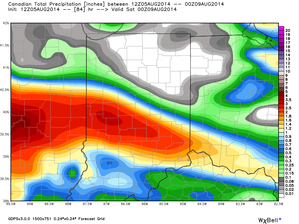
The Canadian forecast model has remained most consistent on Friday’s forecast and holds firm on an axis of heavy rain through central Indiana.
Cold Front Just North…A cold front will slowly sag south into central Indiana over the next 24 hours before stalling nearby. Some added energy will rotate along the boundary Wednesday and lead to somewhat more widespread coverage of thunderstorms across the region (scattered to numerous coverage). As far as today- look for more of those splash and dash afternoon and evening showers and thunderstorms, including some locally heavy downpours.
Best Rain Chances Friday? Model data continues to trend towards better chances of widespread moderate to heavy rainfall Friday in response to an area of low pressure moving along the frontal boundary. It’s important to note that there’s still some disagreement among forecast model solutions, but we feel increasingly confident on Friday offering up more in the way of widespread rains in response to this area of low pressure.
Drying Out This Weekend…High pressure will build into the region over the weekend supply drier air and increased sunshine. Perfect timing, heh?!
7-Day Precipitation Outlook:
7-Day Rainfall Forecast: 0.75″-1.25″
7-Day Snowfall Forecast: 0.00″
Before we enjoy a dry weekend, most model data is focusing on Friday for the best chances of widespread rainfall. This is in response to an area of low pressure moving along the tail end of a cold front.