VIDEO: Stormy Afternoon Ahead For Some; Active Pattern Remains…
You must be logged in to view this content. Click Here to become a member of IndyWX.com for full access. Already a member of IndyWx.com All-Access? Log-in here.
You must be logged in to view this content. Click Here to become a member of IndyWX.com for full access. Already a member of IndyWx.com All-Access? Log-in here.
 Highlights:
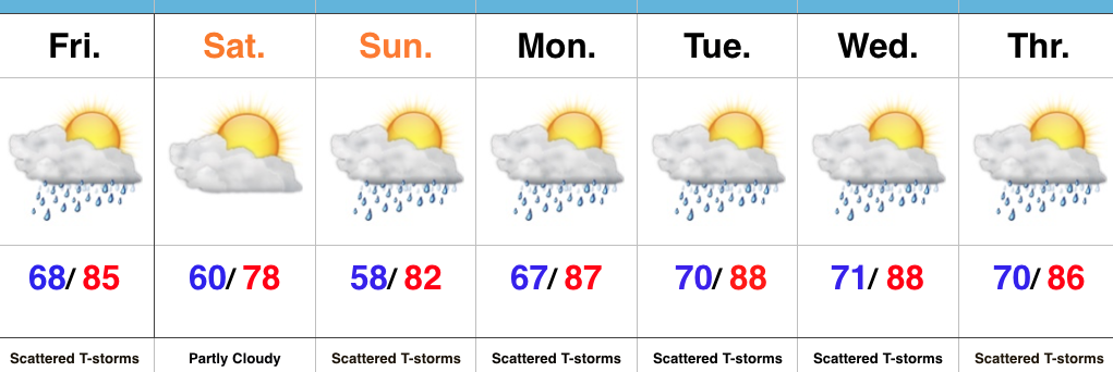
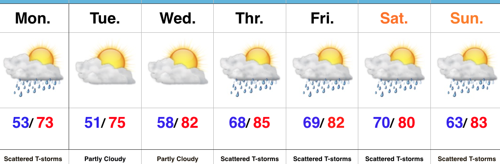
Active Friday For Some…Before we can discuss the pleasant and absolutely gorgeous weather conditions that will welcome in the weekend, we have to deal with a potentially “bumpy” few hours Friday afternoon into the early evening across portions of the state.
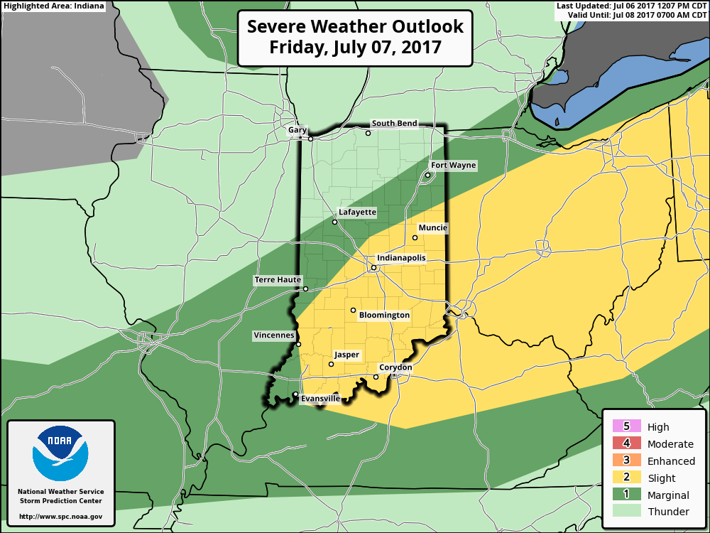
The Storm Prediction Center (SPC) outlines central and southern portions of the state for the threat of severe weather Friday. Damaging straight line winds are the greatest concern with a line of storms that develop Friday afternoon and push southeast. Drier weather will quickly build in behind a cold front Friday evening and help usher in a very pleasant open to the weekend. We’ll certainly notice the lower dew points Saturday and cooler feel with plentiful sunshine. Enjoy it!
Unfortunately the pleasant and dry conditions won’t last very long, and shower chances return as quickly as Sunday afternoon. Humidity and a true tropical feel will also engulf the region next week. This, combined with upper air disturbances moving through the Mid West and Ohio Valley, will aid in daily “splash and dash” thunderstorm coverage. With a moisture-rich air mass in place, stronger storms will produce torrential downpours. Overall, the active and unsettled summer that central Indiana has grown accustomed to shows no signs of let-up in the week ahead…
Upcoming 7-Day Precipitation Forecast:
An early look at the radar this morning shows a couple of lone storms near Decatur and Blufton. These are moving off to the east.
 While we’ll maintain mention of a widely scattered thunderstorm today and Independence Day, the majority of both days will remain rain-free.
A wave of low pressure will track through the Ohio Valley Wednesday night into Thursday and this will result in an uptick in storm coverage. Locally heavy rainfall will be possible. While some localized totals could be higher, we think widespread rains of 1″-1.5″ is a good bet Wednesday night into Thursday.

 High pressure will build in over the weekend and aid in a drier and cooler theme.
 Lows will return to the 50s across central Indiana Sunday morning and refreshing (upper 50s at night and upper 70s to lower 80s during the day) air will remain with us into early next week.
You must be logged in to view this content. Click Here to become a member of IndyWX.com for full access. Already a member of IndyWx.com All-Access? Log-in here.
 Highlights:
Pleasant Start Ends With Storms For Some…We couldn’t ask for more beautiful weather conditions for the last week of June. Hopefully you were able to get outside and enjoy these pleasant conditions over the weekend. If not, you still have a couple days to do so. Despite the sunny start to the day, enough upper level energy will move overhead this evening to help spark scattered showers and thunderstorms. Initially these storms will fire over northern Indiana before settling south through the evening. We think greatest coverage across central parts of the state will arrive between 6p-10p before these storms push south and diminish. Localized brief heavy downpours are possible, but, overall, this won’t be a significant, widespread heavy rain event.
We’re back to dry and pleasant conditions through Wednesday, but humidity will be on the rise by Thursday and so will shower and thunderstorm chances. We’ll have to monitor the potential of a couple rounds of gusty storms and heavy rain late week and we’ll have to fine tune timing as we get closer. Unsettled weather conditions will continue into the holiday weekend ahead.
Upcoming 7-Day Precipitation Forecast: