Heavy Snow For A While Saturday Morning…

We continue to closely monitor the goings on around a late March storm system that promises to provide quite the snow show for some tomorrow morning!  Details can be found…

You must be logged in to view this content. Click Here to become a member of IndyWX.com for full access.  Already a member of IndyWx.com All-Access?  Log-in here.

Slushy Saturday Snow For Some…

Fri.

Sat.

Sun.

Mon.

Tue.

Wed.

Thr.

 Status-weather-showers-day-icon

 Status-weather-snow-scattered-icon

 Status-weather-clear-icon

 Status-weather-showers-day-icon

 Status-weather-clouds-icon

 Status-weather-showers-scattered-icon

 Status-weather-storm-night-icon

39/ 54

31/ 39

26/ 54

34/ 64

42/ 54

38/ 55

50/ 68

Light

Light

– – –

Light

– – –

Heavy

Heavy

Forecast Updated 03.28.14 @ 7:57a

Early Rain. . .Some lingering showers will be possible early this morning, but the majority of the heavier rain and thunderstorms are exiting stage right as we kick off the last day of the work week.  We may even note some afternoon clearing, but otherwise think the day will be a mostly cloudy one, along with steady or slowly falling temperatures and a gusty northwest wind.

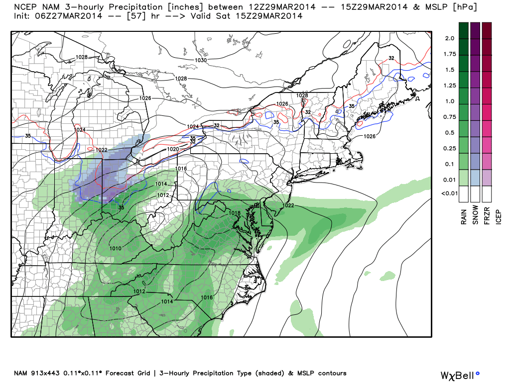
Tricky Saturday Situation; Better Sunday. . .As fast as one storm system departs, our attention has to turn to the next event.  Rain will overspread the area late tonight into early Saturday morning.  As low pressure moves from the southern TN Valley into the central and eastern parts of KY, colder air will be drawn into the storm along the northern periphery of the precipitation shield.  Additionally, precipitation rates will likely be heavy enough to assist in cooling the column of air just enough to allow for a transition to wet snow across portions of the region during the morning Saturday.

While we’re not expecting major snowfall accumulations, it’s likely some communities (especially north and northeast of IND) see a slushy 1-3″ of snow Saturday morning.  It’ll be a wet snow and will likely fall “fast and furious” for a short time period Saturday morning.  Stay tuned as we continue to fine tune.  Otherwise, look for a rather cloudy, cold, and raw day with precipitation ending from southwest to northeast during the late morning into the early afternoon.

After a very cold start to Sunday, that March sun will get to work and help salvage a pleasant second half of the weekend. In fact, Sunday is looking mostly sunny and much milder at this point.

Weak Front. . .A weak front will swing through here late Monday into early Tuesday morning, but moisture will be lacking with this front and a scattered shower or thundershower is possible Monday night.  That said, most will likely remain dry.

Big, Wet Storm System. . .A significant storm system will organize over the Plains by the middle of next week.  Unlike our early week storm, the Gulf of Mexico will be wide open and help supply copious amounts of moisture.  We target Wednesday and Thursday for heavy rain and thunderstorms (some of which may be strong Thursday).  While it won’t rain the entire time, early ideas place 1-2″ of rain down in the Wednesday-Thursday time period alone.

Upcoming 7-Day Precipitation Forecast:

  • 7-Day Rainfall Forecast: 1.5″ – 2.5″
  • 7-Day Snowfall Forecast: 1-3″ 

twicFor weather updates and more “behind the scenes” data on the go, be sure to Follow Us on Twitter @indywx or become a Friend of IndyWx.com on Facebook!

images

Busy Pattern…

A busy weather pattern will keep us on our toes with two storm systems of note between now and Saturday.

Periods of showers will keep most of today wet.  While it won’t rain the entire time, periods of moderate to heavy showers are possible today.  A quick punch of milder air will arrive this afternoon after a chilly start to the day, combined with a strengthening south wind.  Total rainfall today and tonight should average half an inch, or less.

Highs today will reach the lower 50s, despite the showers.

hires_t2m_max_indy_9

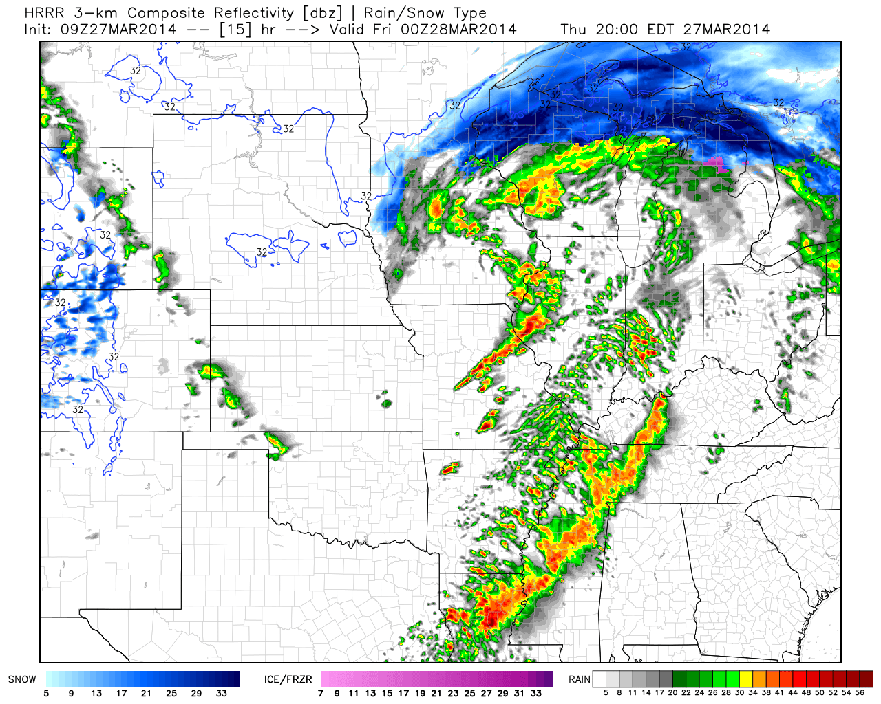
Latest simulated radar data shows the potential of a line of thunderstorms moving through here late tonight, directly associated with the cold front.  A strong storm is possible along with gusty winds as the front slides through early Friday morning.

hires_ref_mw_24hrrr_ref_mc_16

As if all of this wasn’t enough, another storm system will arrive Saturday.  This system will have a wintry component to it, with the chance of a stripe of wet snow along the northern shield of precipitation.  It’ll require our attention as we move forward.  March storms have been known to have a surprise or two and it’s our job to try and help eliminate any of these surprises.

nam_ptype_slp_ma_20


Catching Up After A Day Outside Enjoying This Weather…

1.) We don’t really have any changes to the going snowfall accumulation forecast we have out concerning Wednesday.  We think Indianapolis accumulates 2″, with heavier amounts north of the city…

You must be logged in to view this content. Click Here to become a member of IndyWX.com for full access.  Already a member of IndyWx.com All-Access?  Log-in here.

Active Thursday Ahead…

* Your complete 7-Day forecast can be found below this post.

We continue to monitor things closely Thursday as a busy day is on tap.  Thunderstorms will initially blow into the region Thursday morning as a warm front lifts north through central Indiana.  These storms will be capable of producing heavy rain and vivid lightning.

T-stormsRound1

We’ll then get into a much warmer south wind (gusting up to 30 MPH) and watch radar trends closely to our west.  We’re still very concerned for a squall line plowing east through the region Thursday evening.  Time of greatest concern lies between 5PM and 8PM for this line, but we caution timing may have to be adjusted after looking over evening data.  Damaging straight line winds are of the greatest concern Thursday evening, along with torrential rainfall.

ThrSeverThreatSIMRadarFollowing the squall line, we’re also concerned for strong and potentially damaging northwest winds Thursday night, gusting up to 50 MPH, as low pressure rapidly deepens moving into the Great Lakes.

Bullet Point Thoughts You Need To Know For Thursday

  • Morning round of heavy rain and thunderstorms
  • Severe squall line capable of wind gusts over 60 MPH Thursday evening- targeting 5pm to 11pm
  • Heavy rain totals around 1″
  • Strong northwest winds Thursday night that could gust up to 50 MPH