Heavy Rain And Storms Thursday; Phenomenal Weekend Ahead…
 Highlights:
- Turning more humid this afternoon
- Heavy rain Thursday
- Cooler and drier weekend ahead
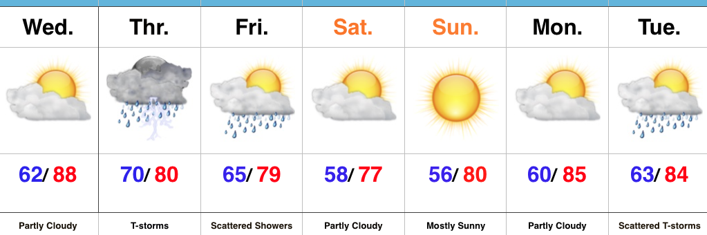
Heavy Rain Tomorrow…Wednesday is getting off to a pleasant and beautiful start across the Hoosier state. Sunshine will be with us throughout the day, but our pleasant air mass that we’re awaking to will grow increasingly moist this afternoon and evening. Our next storm system approaches late tonight and will help push widespread rain and thunderstorms across the state early Thursday morning. With such high water content in our air mass, expect periods of heavy rain across the region. Localized flooding will result.
The trade off to the wet and stormy Thursday will be an incredible weekend. Despite a few lingering showers Friday, we’ll notice a dramatic drop in humidity Friday night and this will set the stage for a refreshing last weekend of July. In fact, temperatures will grow cool enough both Saturday and Sunday mornings to perhaps trigger a feel of early autumn for some. Plentiful sunshine can be expected along with unseasonably low dew points with a northeasterly flow in place.
Temperatures and moisture levels will slowly increase as we get into early next week. With the increasing humidity, expect increasing chances of showers and thunderstorms towards the middle of next week.
Upcoming 7-Day Precipitation Forecast:
- Snowfall: 0.00″
- Rainfall: 2.00″ – 3.00″
 Highlights:
 Highlights: