Category: Hail
 Highlights:
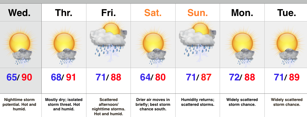
- Big time heat and humidity through late week
- Watching storm chances Wednesday night
- Briefly drier air Saturday
- Summer-like pattern continues next week
The big weather story over the second half of the week will be the heat and humidity. Many will reach, or exceed, the 90 degree mark Wednesday and/ or Thursday. We’ll keep a close eye on the northern portions of the state for storms to initialize Wednesday afternoon/ evening. Those at greatest risk for strong to severe storm potential will be from areas along and north of the I-70 corridor Wednesday evening. Damaging winds and hail are of biggest concern.
A cold front will slide into the area Friday and provide better coverage of showers and thunderstorms Friday afternoon and night. Latest model runs then deliver a briefly drier surge of air Saturday and we’ll lean in that direction with our Saturday forecast for now. Don’t get used to the drier air as heat and humidity will be plentiful early next week, along with renewed shower and storm chances.
Upcoming 7-Day Rainfall Potential: 1″ – 1.5″
Permanent link to this article: https://indywx.com/hello-summer/
 Highlights:
- Stormy tonight for some
- Heat builds this week
- Better storm chances return for the weekend
A cold front remains off to our northwest as we type this and big storms are firing across northern portions of the state. We’ll keep a close eye on those as they move southeast tonight and begin to pick up more forward momentum in the coming hours. They’ve had a history of producing damaging hail. Remain weather-aware this evening.
Thankfully we’ll begin to inject a drier air mass (briefly) into the region Tuesday. A nice day is coming with lower humidity. Most of the second half of the work week will also remain dry, but as humidity increases we have to mention the threat of an isolated to widely scattered storm. The big story will be the heat as highs push into the 90 degree territory. Prepare to sweat!
Better chances of showers and thunderstorms will push back into the region over the upcoming weekend. We’re not forecast a complete washout either Saturday or Sunday, but with a very humid air mass in place, any shower or storm that develops will have the capability of producing torrential downpours.
Upcoming 7-Day Rainfall Potential: 1.5″ – 2.5″
Permanent link to this article: https://indywx.com/storms-tonight-heat-builds-this-week/
 Highlights:
- Strong to severe storms possible Tuesday afternoon/ evening
- Drier skies Thursday-Friday
- Weekend cold front
 Forecast radar above (courtesy of Weatherbell.com) shows our next weather concern and that has to do with an upper air disturbance moving northeast tonight into Tuesday. This will likely ignite scattered strong to severe thunderstorms across the area Tuesday afternoon and evening. Remain weather-aware tomorrow for the possibility of these severe storms. Large hail is the big concern. Should we see morning sunshine of significance then that would “up the ante” for afternoon severe potential. We remain in a rather unsettled, warm, and humid pattern this week, but there will be plenty of dry time. Coverage of thunderstorms Thursday and Friday will be diminished from what we can expect tomorrow and Wednesday. A cold front will arrive over the weekend, helping to increase shower and thunderstorm coverage.
A blend of short and mid range computer guidance prints out an average of 1.5″-2″ of rain over the upcoming ten days. This is needed after what’s been several weeks in a row of a lack of widespread rains.
Permanent link to this article: https://indywx.com/strong-to-severe-storms-possible-tuesday-pm/
We continue to closely monitor the threat of severe weather today. Best chances of severe thunderstorms likely will come this afternoon into the early evening hours from west to east,…
You must be logged in to view this content. Click Here to become a member of IndyWX.com for full access. Already a member of IndyWx.com All-Access? Log-in here.
Permanent link to this article: https://indywx.com/severe-weather-potential-today/
-
Filed under 7-Day Outlook, Forecast, Hail, Heavy Rain, HRRR, Rain, Severe Weather, Spring, Summer, T-storms, Unseasonably Cool Weather, Unseasonably Warm
-
May 9, 2015
 Highlights:
- More dry time than not this weekend
- Strong storm potential Monday
- Cooler and much drier air moves in Monday night
The region remains in a very warm and moist air mass this weekend and this could help promote a scattered shower or thunderstorm really at any point over the next couple of days. That said, best concentration of rain and storms will come during the afternoon and evening hours. All-in-all, the weekend will feature many more dry hours than not. A final push of showers and thunderstorms will blow through Monday and some of these could reach strong to severe levels. We’ll keep a close eye out. A much cooler and drier air mass arrives Monday night and that will carry us through Thursday.
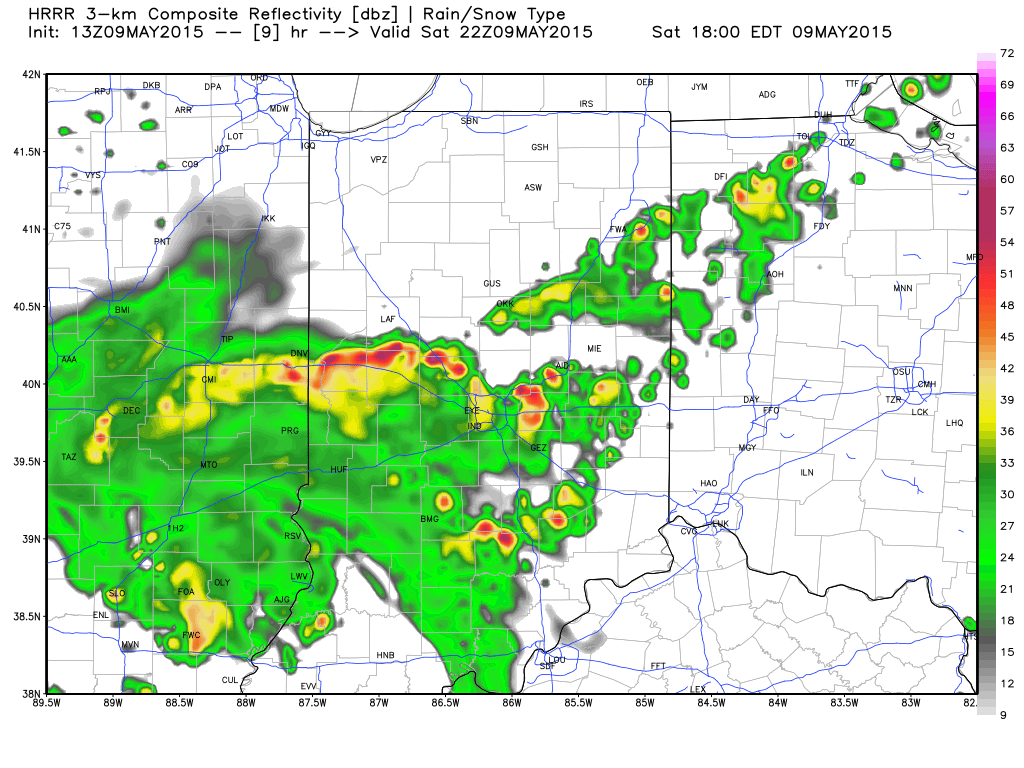
 Most of today will be dry, but forecast radar (courtesy of Weatherbell.com) suggests showers and thunderstorms build into central IN this afternoon and evening. Plan on taking rain gear with you if you have outdoor plans and have a means of getting inside should a storm be nearby.
 The SPC has highlighted a large portion of the Ohio Valley for the threat of severe weather Monday. Large hail and damaging winds appear to be of greatest concern at this time. While this doesn’t look like a significant widespread severe weather outbreak for our immediate region, let’s remember it only takes one severe storm impacting a community to be significant in that particular neighborhood.
Permanent link to this article: https://indywx.com/lots-of-dry-time-this-weekend-but-scattered-storms-will-be-around/


