Category: GFS

Here We Go Again…

What a weather year this has been for central Indiana.  Snow and cold translated to wet and stormy as winter turned to spring.  Now as summer rumbles into the supposed “dog days” we’re really left with the exact opposite.  Our weather pattern will be dominated by a fast moving northwest flow over the upcoming (7) days and this spells an active and stormy open to the work week and next weekend, with an “island” of cool, pleasant weather thrown in the mix Wednesday through Friday.

The GFS operational run shows that we’ll remain locked into the rather active northwest flow pattern through the upcoming week.  Note that while the trough axis moves east with time, the northwest flow remains intact.

1


2


There’s excellent ensemble support from the GEFS and EC, as well.

a

b

The end result is a (7) day stretch that remains cooler than normal when all added up, highlighted by the cooler punch of air (worthy of open windows yet again) Wed-Fri.

4

This also remains quite the active pattern in regards to thunderstorm complexes and rounds of locally heavy rainfall.  We bracket late tonight into Monday morning and again Monday night into Tuesday, followed by next weekend for possible storm complexes that will make for a rather noisy time of things here.  As for the severe threat, we’ll have to keep a close eye on each complex.  It’s possible one or two of these could pose a damaging wind threat as they race southeast and that’s our biggest concern as of now.

When you total it all up, the upcoming (7) day period, July 7th-14th, is likely to lead to more significant rainfall over the region.  The Canadian isn’t holding back, suggesting widespread 2-3″ totals.  That may be a bit “bullish,” but we’ll forecast 1.5″-2″ with ease during the upcoming week, including locally heavier totals.

5

Quick summary:

Monday through Tuesday will be highlighted by rainy and stormy periods before we introduce a much cooler and drier regime Wednesday through Friday.  Humidity builds over the upcoming weekend with additional rain and thunderstorm chances returning.

Permanent link to this article: https://indywx.com/here-we-go-again-2/

Quick Friday Evening Video Update

Seems like a broken record, but more showers and thunderstorms dot the central Indiana landscape this evening and will continue over the weekend, though no all day rains are anticipated.  Additionally, we’re still tracking well below normal air for the all-important holiday weekend next week.  Details in a quick Friday evening video update below!

A cooler than average pattern continues to look likely for the all-important July 4th weekend.

A cooler than average pattern continues to look likely for the all-important July 4th weekend.

Permanent link to this article: https://indywx.com/quick-friday-evening-video-update/

Hot Weekend Coming, But We’re Set To Cool Going Into The Holiday…

The pattern continues to look as if it’ll evolve in a way that will assist in delivering the hottest air so far this year during the course of the upcoming weekend into early next week.  That said, the seeds are once again being planted that should promote a trough and associated cooler than normal pattern returning as we head closer to the Independence Day holiday.

In short, an active and progressive pattern is set to continue across our immediate neck of the woods.  This promises a continuation of above average precipitation and while shots of hot air will invade from time to time, it’s going to be mighty tough to get any sort of hot pattern to stick around for any sort of staying power over the course of the upcoming couple weeks.

In the short-term, we’ll enjoy a couple of cooler, drier days for the mid week stretch, but ridging will build this weekend into the middle part of next week and we should have no problem reaching the hottest levels of the year so far.  Note, however, how the upper pattern reverses and allows a trough to develop over the Lakes and Ohio Valley by Day 10, or the Independence Day holiday.

z500_anom_f144_ussm

z500_anom_f240_ussm


There’s relatively good agreement between the GFS and European during the 8-10 day period with the trough and associated cooler pattern returning.

test8

The NAEFS and CFSv2 highlight the warmer than normal pattern giving way to cooling week 2.

2014062412_054@007_E1_north@america_I_NAEFS@TEMPERATURE_anomaly@probability@combined@week2_186


wk1.wk2_20140623.NAsfcT


The GFS ensembles show the transient regime ahead.  Note the warming giving way to cooling and then warming again towards week 3.  Again, this is a good indication of wetter than normal conditions as well across a good portion of the Mid West and Ohio Valley.

gefs_t2anom_16_conus_1

To sum things up, the hottest air so far this year will likely move into the Hoosier state early next week and feature a day or two of 90 degrees +.  The heat won’t have staying power as a trough and associated cooler air mass will return heading into the Independence Day holiday, and could potentially be highlighted by a round of gusty storms as the heat gives way to cooling.  We’ll have to keep an eye on this as we draw closer.

Permanent link to this article: https://indywx.com/hot-weekend-coming-but-were-set-to-cool-going-into-the-holiday/

Boone County, Central Indiana Flooding 6/19/14

A rather rare flood event took place across localized areas of central Indiana between Wednesday, June 18th, 2014 and Thursday, June 19th, 2014.  (27) hour rainfall totals 4pm Wednesday, June 18th through 7pm Thursday, June 19th reached 5.5″ (5) miles northwest of Zionsville, IN in southeastern Boone County, IN.  2.9″ of that rain fell in less than a (3) hour period between 4pm and 7pm Thursday, June 19th.

Local Agriculture impact:

Numerous central and southern Boone County crops experienced some sort of damage from rapid run off of the torrential rainfall.  Communities and farmland impacted included Lebanon, Whitestown, and Zionsville.

photo 5-2photo 4-3photo 3-3photo 2.PNGphoto 1-3


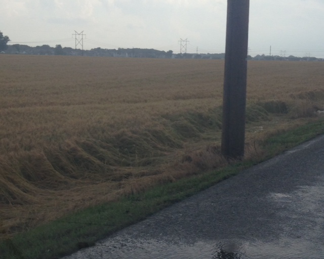
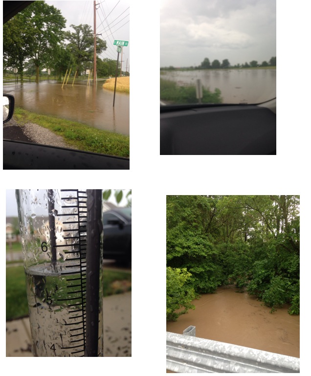
Ground-truth reports taken at our IndyWx.com headquarters (5 miles northwest of Zionsville, just outside Whitestown, IN) recorded 5.5″ of rain within the (27) hour period mentioned above.

Radar estimated data also shows the widespread 4-5″+ rainfall totals across Boone County over the past 24 hours- Wednesday, June 18th through Thursday, June 19th.

photo-10

Forecast model data from as early as Thursday morning suggested that particular afternoon and evening could feature training of heavy rain producing thunderstorms through central Indiana, including some embedded strong to severe thunderstorms, despite the Storm Prediction Center including central Indiana in any sort of severe weather categorical outlook (Slight Risk, or above).  That said, it should also be noted that this wasn’t a major severe weather outbreak across central Indiana, though isolated severe weather reports did come in, including a brief tornado touchdown near Anderson Thursday afternoon, along with a couple of additional severe thunderstorm warnings.  That said, the purpose of this post will focus on the set-up for heavy, and in some cases excessive, rainfall “training” (moving repeatedly over the same locale) over central Indiana communities Thursday afternoon/ evening.

First, let’s take a look at the broad scale pattern set-up.  Needless to say, it’s certainly easy to see why localized flash flooding developed.

Thursday morning’s 06z model runs suggested CAPE values, or Convective Available Potential Energy, would reach 4800-5000 across central Indiana.  You can look at CAPE as the “umph,” or fuel, that basically will feed a thunderstorms it’s energy.  Anything over 2000 is considered plenty enough for strong thunderstorm potential.

hires_cape_ky_13The overall upper air pattern and steering currents suggested portions of the Ohio Valley would be under the gun, so to speak, for potential training of heavy rain and associated thunderstorms.

gfs_z500_uv_vort_east_5

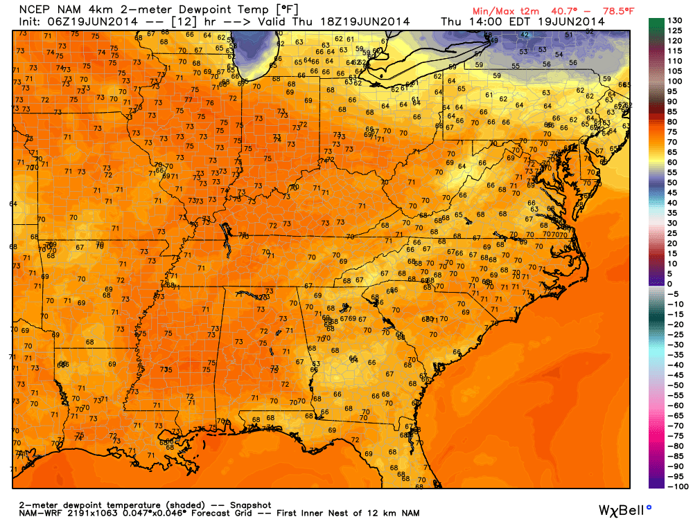
Rich tropical moisture was readily available across the area, indicative of 06z forecast dew points in the upper 60s and lower 70s across the Ohio Valley region.

hires_dew2m_ky_13

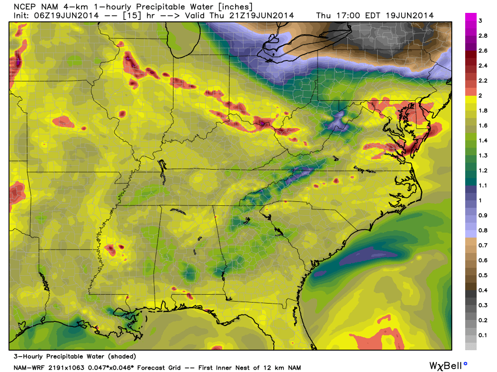
Perhaps the more telling story had to do with the forecast PWAT, or Precipitable Water, values that exceeded 2″ to 2.4″ across portions of central Indiana from the 06z model run Thursday morning.  PWAT values are a good indication of heavy rainfall potential should there be something to trigger (lifting mechanism) showers and storms.  PWAT values of 2″ and above are considered extreme and rather rare, even for this time of year.

We tip our hat to the 06z 4km NAM picking up on this early Thursday morning as it very closely matched where training thunderstorms and heavy rain initiated Thursday afternoon.  Take a look at the forecast PWAT levels and the afternoon radar on Thursday, June 19th, as storms began to develop:  Note rainfall rates exceeded 2″/ hr. across portions of central Indiana, including Boone County on the afternoon of June 19th.

hires_pwat_ky_16

photo-11

Compare that to the forecast radar from another one of our short-term, high resolution, forecast models, the HRRR, valid 6pm:

hrrr_ref_indy_2

(We want to thank the fine folks at Weatherbell Analytics for some of the forecast model images.  Additionally, thanks to Radarscope for the radar storm rainfall totals).

In closing, a combination of ingredients came together to present a localized, yet very significant flood event, for central Indiana.  The upper air pattern promoted movement of abnormally moist air to stream north into the Ohio Valley region.  At the same time, the same pattern resulted in a steering current that was relatively weak across our immediate region- adding to the potential of training.  The storms actually initiated (formed) along an old outflow boundary from the previous night, Wednesday, June 18th/ early morning Thursday, June 19th.

The days ahead will continue the unsettled theme across the region and we’ll have to remain on our toes for potential additional significant weather impacts as we move forward Friday, and even into the weekend.  Much more later.

Permanent link to this article: https://indywx.com/boone-county-central-indiana-flooding-61914/

Remaining Active…

Thr.

Fri.

Sat.

Sun.

Mon.

Tue.

Wed.

 Status-weather-showers-day-icon

 Status-weather-showers-day-icon

 Status-weather-showers-day-icon

 Status-weather-clouds-icon

 Status-weather-showers-day-icon

 Status-weather-showers-day-icon

 Status-weather-showers-day-icon

70/ 87

69/ 84

66/ 85

64/ 86

66/ 89

66/ 80

66/ 78 

Light

Light

Light

– – –

Light

Light

Light

It was a rather noisy evening across north-central Indiana with numerous strong to severe thunderstorms that dumped torrential downpours and provided damaging wind for some.  While rainfall totals certainly weren’t “uniform,” many communities received anywhere from 1.5″ – 2.5″ of rain between the two rounds of storms.  Today and Friday are liable to be another couple of active days as the heat, humidity, and instability builds during the afternoon.  Heavy showers and embedded stronger thunderstorms will likely fire across central Indiana this afternoon.  Locally heavy rain can be expected with any storm that develops.  As we move forward, we still think we can introduce slightly drier air into your weekend forecast with rain coverage greatly reduced Saturday and almost non-existent Sunday.  Next week poses a whole set of problems as forecast models aren’t in agreement in the least.  For now we’ll go with a blend, leaning slightly more in the direction of the cooler/ drier GFS by the middle of next week as it’s been performing nicely with the cooler, drier air masses so far this spring and summer.  Stay tuned.

Permanent link to this article: https://indywx.com/remaining-active/