Category: Forecast

Dry, Warm Week…

screen-shot-2016-09-18-at-8-36-26-pmHighlights:

  • Dry week for the most part
  • Unseasonably warm
  • Significant cold front looms

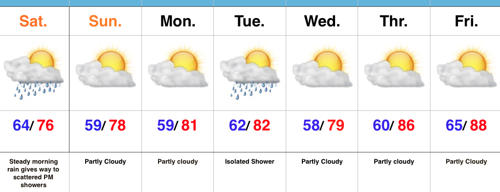
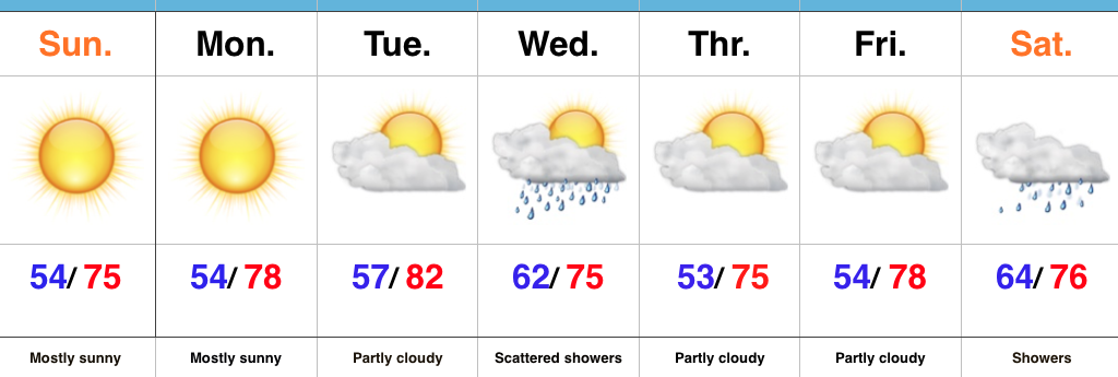
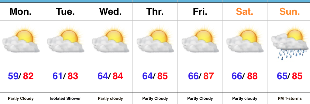
Extended Stretch Of Dry Weather…Despite a weak frontal boundary getting close enough to create an isolated shower Tuesday, we’re looking at dry conditions this week, complete with plentiful amounts of sunshine.  Average temperatures for mid September include lower 50s for lows and highs in the lower 70s.  With highs this week surging into the middle to upper 80s with lows in the middle 60s, it’s safe we’ll enjoy some bonus “summer time!”

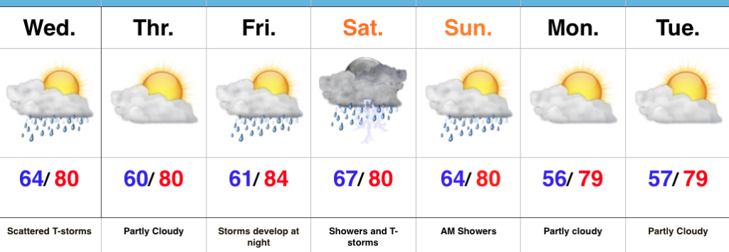
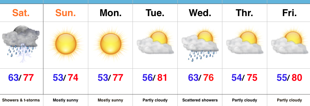
For those longing for the chilly, crisp conditions of the fall season, hang in there.  A strong cold front will approach the region late in the weekend and will be accompanied by showers and thunderstorms late Sunday into Monday. MUCH cooler air awaits behind the boundary…

Upcoming 7-Day Precipitation Forecast:

  • Snowfall: 0.00″
  • Rainfall: 0.50″ – 1.00″

Permanent link to this article: https://indywx.com/dry-warm-week/

Drying Out; Late Season Push Of Summer Air…

screen-shot-2016-09-17-at-10-22-44-amHighlights:

  • Showers become more scattered this afternoon
  • Nice Sunday on deck
  • Late season push of summer heat before cooler times

Drying Out Sunday…It was a wet and stormy night across central IN, including locally hefty rainfall totals (some neighborhoods picked up more than 2″).  We’ve been dealing with widespread soaking rain across central IN through the morning, but as we progress into the afternoon, most concentrated rain will remain east of the city and on into Ohio.  Scattered showers will remain possible until the cold front presses through the region tonight.

High pressure will build overhead Sunday and supply increasing sunshine and a pleasant second half of the weekend.  Lower humidity will promote overnight lows into the upper 50s to open the week.

A secondary (weak) front may yield an isolated to widely scattered shower Tuesday, but the bigger story will be late season heat building to close the week.  Highs will approach the 90 degree mark by Friday as a big ole ridge expands across the region.

Longer term, a significant cold front looms just beyond the current forecast period that will offer up thunderstorms and a big blast of fall-like air to close the month…

Upcoming 7-Day Precipitation Forecast:

  • Snowfall: 0.00″
  • Rainfall: 1.50″ – 2.00″

Permanent link to this article: https://indywx.com/drying-out-late-season-push-of-summer-air/

Scattered Storms Today; More Widespread Rain Saturday…

screen-shot-2016-09-14-at-7-41-26-amHighlights:

  • Scattered storms
  • More concentrated; heavier rain this weekend
  • Drier to open the work week

Scattered Storms Around…A weak frontal boundary will kick up a couple of scattered storms today.  While rainfall totals won’t be uniform (some may not even see any rain at all), a couple of heavier downpours are a good bet.  We’ll notice a drier and slightly cooler air mass overnight into Thursday.

The dry time won’t last long as a more significant storm system approaches this weekend. Most of the daytime Friday should be dry, but rain and storm chances will increase Friday night and Saturday continues to look wet with periods of showers and thunderstorms.  Morning showers will impact portions of the region Sunday before we dry things out Sunday PM.  Dry times continue to open the new work week.

Upcoming 7-Day Precipitation Forecast:

  • Snowfall: 0.00″
  • Rainfall: 1.00″-1.50″

Permanent link to this article: https://indywx.com/scattered-storms-today-more-widespread-rain-saturday/

Gorgeous Open To The Week…

screen-shot-2016-09-11-at-10-24-00-amHighlights:

  • Sun-filled days
  • Crisp air
  • Midweek showers
  • Saturday rain

Fall Feel…Sprawling high pressure will supply a dry open to the week, complete with plentiful sunshine and dry air.  Conditions will be beautiful to spend time outdoors- very much like early fall.

Our next weather maker will scoot through the region Wednesday with scattered showers. Once  the front blows through, reinforcing cool air will press into the state Wednesday evening.  A few reports of upper 40s will be likely away from the city Thursday and Friday morning.

While timing is still a bit up in the air at this distance, Saturday is looking unsettled as another cold front blows through.  (Get the idea we’re in an active period)?

Upcoming 7-Day Precipitation Forecast:

  • Snowfall: 0.00″
  • Rainfall: 0.50″-1.00″

Permanent link to this article: https://indywx.com/gorgeous-open-to-the-week/

Drier, Cooler Air On Our Doorstep…

screen-shot-2016-09-10-at-9-20-41-amHighlights:

  • Greatest storm coverage and intensity this morning
  • Turning much drier and cooler
  • Reinforcing mid week cool air

Turning Much Drier This Evening…It’s been a wet and stormy time of things as of late.  Locally heavy rain will continue to accompany stronger storms this morning, but we note greatest storm coverage should begin to shift ENE as the morning progresses into afternoon.  Renewed showers will likely develop this afternoon as the cold front moves through the state.  We’ll then enjoy a marked NW wind shift this evening and that will help push much drier and cooler air in to help create a true fall feel tonight.  The second half of the weekend look beautiful- sunny and crisp!

Much needed dry time will be with us for the balance of the upcoming work week.  We note a reinforcing push of cool air mid week that could spark a shower, but rainfall amounts don’t look impressive (the air will be much drier than the “soupy” feel we’ve been dealing with for the past week).  A more significant rain-maker should arrive next weekend…

Upcoming 7-Day Precipitation Forecast:

  • Snowfall: 0.00″
  • Rainfall: 1″-2″

Permanent link to this article: https://indywx.com/drier-cooler-air-on-our-doorstep/