You must be logged in to view this content. Click Here to become a member of IndyWX.com for full access. Already a member of IndyWx.com All-Access? Log-in here.
Category: Forecast
Permanent link to this article: https://indywx.com/2015/02/24/tuesday-evening-video-update-lots-of-winter-on-the-table/
Feb 23
Busy Winter Weather…
February has been a brutally cold month and there’s no let-up in sight during the upcoming 7-10 days.
 The snowpack has expanded over the past few days.
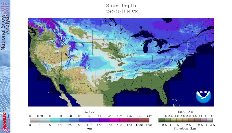 The arctic air is very hard to move and forecast models can struggle mightily in the mid range when arctic air is involved. Add in a vast snowpack over the TN Valley and Ohio Valley and I wouldn’t buy full force into the warm, mostly liquid precipitation solutions as depicted by some European and GFS runs as of late. More on that later.
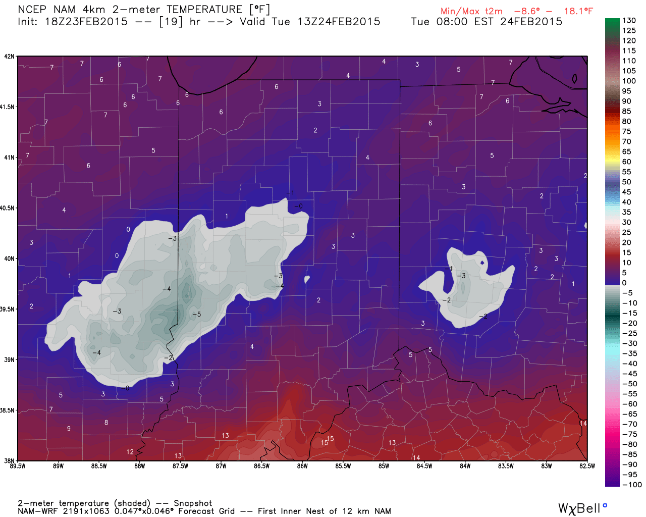
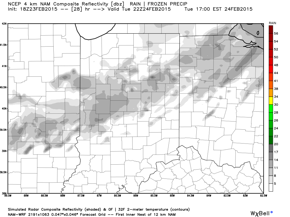
Arctic air is the story in the short-term along with a gusty wind that will precede very light snow Tuesday afternoon/ evening.
 More bitterly cold, arctic air will be with us as we wrap up the work week and head into the weekend. Additional records will fall.
Snow may also be with us. We’re keeping a close eye on a clipper system that could deliver accumulating snow prospects around these parts Wednesday night/ Thursday. The latest RGEM solution (below) depicts a more easterly track. We also note the latest GFS delivers light snow in here Wednesday night and Thursday, as well. We’ll keep a close eye on things.
 Late weekend into early next week features another complicated and very complex event. We believe it’s far too early to buy into any one particular solution provided by the various forecast models, but certainly have to “raise an eyebrow” to the mostly wet, warmer solutions. There’s an awful lot of dense arctic air around and with a widespread snowpack we have to wonder if modeling may be overdoing the warming (where have we seen this before ;-)).
A wavy front may lead to more wintry “mischief” Sunday into early next week. Again- far too early for specifics, but additional wintry weather is certainly possible.
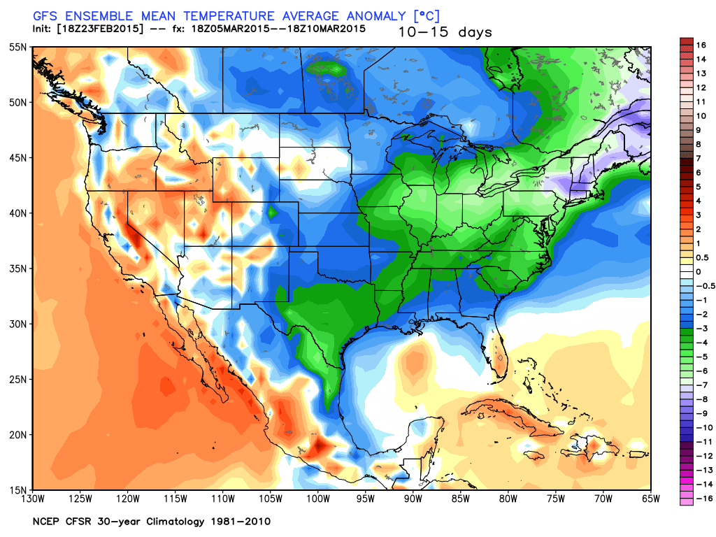
 In the longer term, there’s just no let up in sight from the colder than normal conditions. Sure we may see a couple of days of milder air (we are heading into March, after all), but, as a whole, the majority of the upcoming couple weeks look MUCH colder than normal.
Permanent link to this article: https://indywx.com/2015/02/23/busy-winter-weather/
Feb 23
Brutally Cold Week…
 Bundle Up…A series of arctic highs will build south and result in an absolutely frigid week across a large portion of the country, including here on the home front. Several cold records will fall this week.
For the most part, we’re looking at a dry week, but a skinny band of light snow may blow through the area Tuesday afternoon/ evening- not a big deal.
Models are struggling on the details with our next storm system. It’s possible we’ll have to add a wintry mix of rain and snow into your Sunday forecast, but prefer to wait another set of runs before doing so. Timing and track remain big questions at this point- common from a Day 6+ event. The GFS and European lean towards a milder, wetter event while the Canadian is colder and more suppressed. Much more on this later.
Upcoming 7-Day Precipitation Forecast:
- 7-Day Snowfall Forecast: Dusting
- 7-Day Rainfall Forecast: 0.00″
Permanent link to this article: https://indywx.com/2015/02/23/brutally-cold-week/
Feb 22
Bitterly Cold Week…
 Frigid Times…If you haven’t done so already, we highly recommend cleaning up from yesterday’s snow storm as the bitterly cold conditions moving in this evening will turn any left over slush into concrete.
Most of today will feature dry conditions, but we’ll note scattered flurries and light snow this afternoon as arctic air pours into the region. Winds will also increase and gust upwards of 20 MPH by evening. The combination of wind and cold will lead to dangerous wind chill values of 15 to 25 degrees below zero tonight into Monday morning.
Reinforcing arctic air will build into the region with a burst of light snow Tuesday afternoon. This will only help to drive home the point of our title above- a bitterly cold week is upcoming. Needless to say, we won’t just beat record lows this week, but absolutely smash them.
The next opportunity for a substantial winter event appears to be eyeing us during the upcoming weekend. We’ll have more on this as time draws closer.
Upcoming 7-Day Precipitation Forecast
- 7-Day Rainfall Forecast: 0.00″
- 7-Day Snowfall Forecast: Dusting to 1″
Permanent link to this article: https://indywx.com/2015/02/22/bitterly-cold-week/
Feb 21
Saturday Morning Update
Good snowy Saturday morning, friends! We’re getting reports of 3″-5″ of snow so far across central Indiana from “round 1” of our winter storm. While heavy snow bursts remain on radar this morning (case in point from Whitestown down to the west side of Indianapolis), the widespread snow has come to a brief end. Brief is the key word here as widespread snow will overspread most of the region late morning into early afternoon. An additional 1″-2″ of snow will be a good bet from “round 2.”
Here’s a snap shot of what the radar may look like later this morning- centered on 11a.
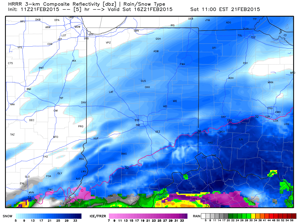 As we push deeper into the afternoon, snow should slowly press south and east of our region. It’ll be important to go ahead and begin the big dig as cold reloads tonight into Sunday and another record cold shot eyes the region early next week.
We’ll have more on your 7-day forecast later today, including another potential winter storm late in the period. For now, enjoy the snow!
Permanent link to this article: https://indywx.com/2015/02/21/saturday-morning-update/
Feb 20
Winter Storm Video Brief
You must be logged in to view this content. Click Here to become a member of IndyWX.com for full access. Already a member of IndyWx.com All-Access? Log-in here.
Permanent link to this article: https://indywx.com/2015/02/20/winter-storm-video-brief/
Feb 20
Winter Storm Tonight-Saturday
Good morning and happy Friday, friends! Boy, Old Man Winter is really beginning to turn some minds around from thinking this was an easy winter to one that’s quite impressive, especially from a cold standpoint. By the way, there’s MUCH more from where this came from! Essentially we remain on “lock down” for more brutally cold and wintry conditions for the upcoming 7-10 day period. More on that later.
Here’s a look at our initial snowfall forecast map for tonight and Saturday:
 Forecast radar shows heavy wet snow encompassing central Indiana Saturday morning:
 Bullet point highlights you need to know:
- Snow will overspread central Indiana from the southwest between 10p-1a
- Snow will become heavy at times between 3a-7a
- Sleet and freezing rain will accumulate significantly downstate
- Most of the snow will be east of the area by 3p Saturday
- You’ll want to plow and clean snow up Saturday night as cold air quickly returns Sunday
- Arctic outbreak next week likely will feature record cold, and colder than this week has been
- No let-up in sight from this unrelenting winter pattern
Permanent link to this article: https://indywx.com/2015/02/20/winter-storm-tonight-saturday/
Feb 19
Arctic Express Rolling Down The Tracks…
 Heavy Cold Weather Gear Needed…It’s a frigid morning across central Indiana with all reporting sites well below zero. Despite the sunshine today, we’ll only “warm” into the middle single digits- smashing the former record cold maximum of 12 degrees. Amazing stuff! Wind chills will remain below zero and downright dangerous.
Eyes shift to a wintry weather maker this weekend and overnight computer guidance has begun to catch onto a much more realistic suppressed, colder solution, as opposed to the warmer and more aggressive storm into the Ohio Valley. We still have time to watch for additional changes, but for now we think light snow overspreads central Indiana Friday evening, before a bit heavier precipitation moves in late Friday night and Saturday morning. The “2nd round” of precipitation will likely consist of most of the ice/snow accumulation, including mostly snow across north-central Indiana, a messy mix of sleet and freezing rain across the heart of central Indiana, and a cold rain downstate. Caution though that this is still preliminary thinking and certainly subject to change. An early guesstimate on central Indiana snowfall potential with this system would be for a light to borderline moderate event- 2″ to 4″ type deal.
The Arctic Express quickly gains momentum yet again Sunday night and will lead to another frigid week next week. This pattern is getting to be unbelievable from both the sustained cold, but the extreme nature of the cold, as well. Put this into perspective, only three days of the above forecast period feature high temperatures close to, or slightly warmer, than our average low.
Upcoming 7-Day Precipitation Forecast:
- 7-Day Snowfall Forecast: 2″ – 4″
- 7-Day Rainfall Forecast: 0.10″
Permanent link to this article: https://indywx.com/2015/02/19/arctic-express-rolling-down-the-tracks/
Feb 17
Record Cold Air Ready To Blow In…
 Heavy Duty Cold Weather Gear Needed…If you didn’t think it was cold enough, Mother Nature will try and do better by the middle of the week as downright bitter, and dangerously, cold air blows into town. Scattered snow showers will accompany the arctic blast as a couple of upper level disturbances rotate across the state between today and Wednesday. Wind chills of 20 to 25 below zero can be expected Wednesday night into Thursday morning. Additionally, we’ll run the chance of breaking our coldest high temperature on record for Feb. 19th- Thursday (currently 12 degrees).
After a bitter, but dry couple of days to close the work week, we eye the upcoming weekend for our next storm system. For now we’ll forecast increasing cloudiness late Friday and a wintry mix overspreading the region Saturday. We’ll become more detailed in regards to precipitation type, amounts, and timing over the next day, or two. Fresh arctic air will flow in here to close the weekend.
Upcoming 7-Day Precipitation Forecast:
- 7-Day Snowfall Forecast: 1″ – 2″
- 7-Day Rainfall Forecast: Trace
Permanent link to this article: https://indywx.com/2015/02/17/record-cold-air-ready-to-blow-in/
Feb 15
Incredible Pattern…
 Hope You Like Winter…Many central Indiana neighborhoods are awaking to temperatures this morning between zero and 4 degrees above. It’s a frigid start to the day and sunshine won’t do anything to help us out as highs only manage to climb into the middle teens.
Clouds will increase this evening and tonight and snow will overspread the southern half of the state late tonight and Monday morning. This is from the storm system we said that it was too early to write off last week and that a northern shift was certainly possible as we got closer. Sure enough, the northward jog took place yesterday and puts places from Indianapolis and points south in play for accumulating snow Monday. We’ll continue to look over the data today and tonight and have more specific numbers later tonight.
Yet ANOTHER surge of arctic air will slam in here by the middle of the week and snow showers/ gusty winds will precede the bitter blast. In fact, this 3rd arctic surge looks to be the coldest yet. Amazing stuff!
As we rumble towards next weekend, there’s yet another winter storm we’ll have to keep a watch on…
Upcoming 7-Day Precipitation Forecast:
- 7-Day Rainfall Forecast: 0.00″
- 7-Day Snowfall Forecast: 2″ – 5″
Permanent link to this article: https://indywx.com/2015/02/15/incredible-pattern/

