Category: Forecast

All-Access Client Brief: Latest Thoughts Around This Weekend’s Snow…

Brief: Accumulating snow

Forecaster: McMillan

What: Accumulating snow

When: Late Saturday night into Sunday

Temperatures: Upper 20s to lower 30s

Wind: North 5-15 MPH

Blowing/ Drifting: Minimal

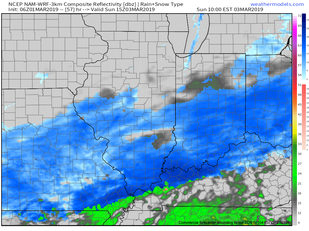
Overnight model trends are in overall better agreement, but still present notable differences- not only with the track, but overall strength and forward motion with the system. Saturday will be dry before clouds increase, lower, and thicken Saturday evening with snow overspreading the southern half of the state overnight. Mainly light to occasionally moderate snow (downstate) can be expected into the daytime on Sunday. The overall quick movement of this storm system will ultimately be a limiting factor in accumulation totals. Behind the system, much colder air will pour into the area Sunday night and Monday (single digit low and highs in the upper 10s to lower 20s).

Confidence: Low-medium

Next Update: This evening in video format

Permanent link to this article: https://indywx.com/all-access-client-brief-latest-thoughts-around-this-weekends-snow/

Heavy Rain Arrives Tonight; Accumulating Snow Band May Setup Shop For Portions Of The Area Tuesday…

A busy pattern continues with heavy rain tonight. Attention then shifts to the potential of a band of accumulating snow, associated with a vigorous piece of upper level energy Tuesday…

You must be logged in to view this content. Click Here to become a member of IndyWX.com for full access.  Already a member of IndyWx.com All-Access?  Log-in here.

Permanent link to this article: https://indywx.com/heavy-rain-arrives-tonight-accumulating-snow-band-may-setup-shop-for-portions-of-the-area-tuesday/

Sunday Morning Video Update: Walking Through The Active Week Ahead; Looking Towards Mid-Feb…

A new week has dawned and with it will come a very busy weather pattern. Thankfully, today we’ll enjoy a “hint of spring,” including temperatures approaching the 60 deg. mark…

You must be logged in to view this content. Click Here to become a member of IndyWX.com for full access.  Already a member of IndyWx.com All-Access?  Log-in here.

Permanent link to this article: https://indywx.com/sunday-morning-video-update-walking-through-the-active-week-ahead-looking-towards-mid-feb/

Bitter Now; Accumulating Snow Inbound Tomorrow Evening…

You must be logged in to view this content. Click Here to become a member of IndyWX.com for full access.  Already a member of IndyWx.com All-Access?  Log-in here.

Permanent link to this article: https://indywx.com/bitter-now-accumulating-snow-inbound-tomorrow-evening/

Snowy Thursday Evening-Friday Morning…

Brief: Accumulating Snow

Forecaster: McMillan

What: Accumulating snow

When: Thursday evening into the predawn hours Friday

Temperatures: 15 to 20 F

Wind: ESE 5-15 MPH

Blowing/ drifting: Minimal

Dangerous cold is the story now, but we still expect an accumulating snow to pile up to the tune of a few to several inches across n-central and parts of central Indiana Thursday evening into the predawn hours Friday. Heaviest snow should fall during a period between 8p and 1a. Snowfall intensity will likely reach 1″/ hr at times as banding develops. We expect all accumulating snow to be over before sunrise Friday morning.

Confidence: Medium to high

Next Update: 6:30p Thursday


Permanent link to this article: https://indywx.com/snowy-thursday-evening-friday-morning/