Category: Forecast

“Not Fit For Man Nor Beast;” Winter Issues This Weekend…

screen-shot-2016-12-14-at-9-20-36-pmHighlights:

  • Bitter feel
  • Weekend storm
  • Reinforcing arctic air to open Christmas week

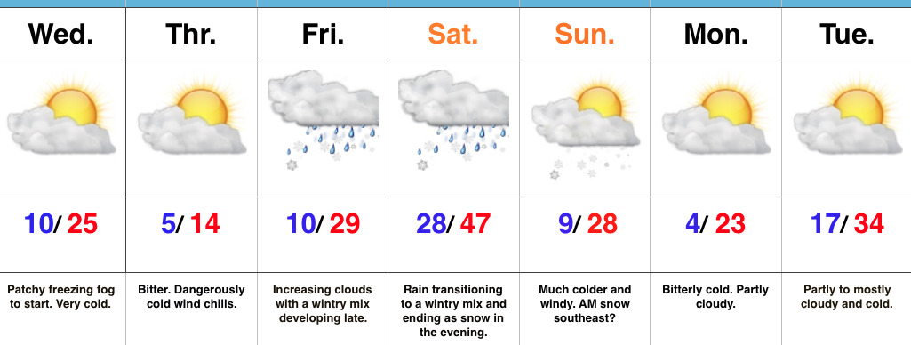
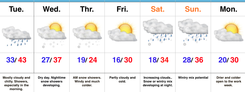
Heavy Winter Gear Required…An arctic cold front slammed into central IN Wednesday evening with plummeting temperatures, strong and gusty (40 MPH) winds, blowing snow, and just a downright “rude” feel.  Those bitter conditions will remain through the close of the work week, including dangerous wind chills Thursday.  In fact, we still expect wind chills to fall into the 10-20 degree below zero range through the morning, and remain below zero most of the day.

We’ll flip the page and turn our attention to our next storm system as we rumble into the weekend.  Clouds will increase Friday and moisture will begin to override the cold air locked in place at the surface by the evening and nighttime.  With sub-freezing air still present, this moisture will likely fall as a combination of sleet and freezing rain across central Indiana Friday night.  Eventually, temperatures will warm (briefly) above freezing Saturday morning and allow precipitation to transition to light rain.  Before that takes place, slick road conditions could develop Friday night from the sleet/ freezing rain mixture.  Needless to say, we’ll keep a close eye on the latest data as it comes in.

Almost as fast as we go above freezing Saturday, temperatures will begin to fall once again during the afternoon and evening as heavy, dense, arctic air “oozes” southeast.  As this is happening, a second wave of moisture will ride northeast along the pressing arctic cold front.  We expect precipitation to break out yet again Saturday evening and night, and fall as a wintry mix before ending as snow.  (Additional light ice and snow accumulation potential).

Temperatures will fall through the day Sunday along with strong and gusty NW winds.  Wind chills will once again fall below zero Sunday evening into Monday morning…

While the frigid conditions will “relax” as we go into the middle of Christmas week, we have an eyebrow raised for the potential of “fun and games” just beyond the current 7-day period.  Far too early for specifics, but the potential of wintry prospects around Christmas are alive and kicking…

Upcoming 7-Day Precipitation Forecast:

  • Rainfall:  0.25″ – 0.50″
  • Snowfall:  1″ – 2″


Permanent link to this article: https://indywx.com/2016/12/14/not-fit-for-man-nor-beast-winter-issues-this-weekend/

Bitter Times Ahead; Weekend Storm…

screen-shot-2016-12-13-at-6-20-11-pmHighlights:

  • Bitterly cold
  • Weekend storm delivers a little bit of everything
  • Cold reloads over the weekend

Cold That Hurts…Tuesday was a snowy day across central IN. Most snow reports checked in around 3″, but there were a few “lucky” folks who accumulated north of 4″.  Not bad at all!

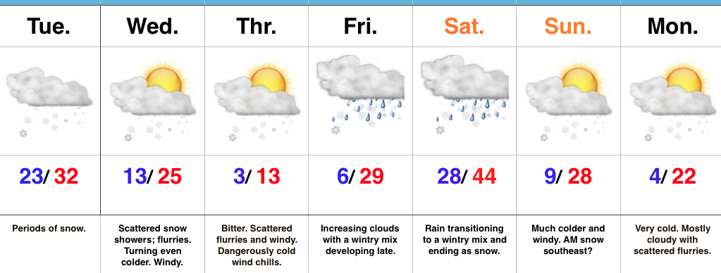
Two pieces of arctic air will invade mid week.  The first piece is arriving on the scenes as we type this forecast Tuesday evening.  It’ll send lows into the single digits to lower teens by Wednesday morning.  Patchy freezing fog will also be noted in spots.  Needless to say, don’t get too confident on area roadways.  Despite the phenomenal work central IN road crews do (seriously, thank you), there will be icy spots tonight and Wednesday morning.  Slow down!  🙂

A second surge of arctic air will arrive Wednesday afternoon and evening.  Everyone gets in on the single digit party Wednesday night and Thursday morning.  In fact, don’t be surprised by a few folks checking in with a below zero report here and there.  Winds will be strong and gusty and lead to wind chill values of 10-20 below zero into Thursday morning.  Heavy winter attire will be required.

Our attention then shifts to a developing weekend storm that will deliver a wintry mix late Friday followed by a transition to rain as temperatures zoom (briefly) into the 40s Saturday.  The milder surge won’t last long as arctic air oozes back into central parts of the state Saturday afternoon and evening.  As this is happening, a second wave of moisture will ride up along the arctic front.  We expect rain to mix with and change to a wintry mix of sleet and freezing rain before ending as snow Saturday night/ early Sunday morning.  This may be another accumulating wintry event and we’ll keep a close eye on things.

Cold, dry weather will be with us as we kick off Christmas week.  Speaking of Christmas week, the bitterly cold air will “relax,” but the pattern remains active.  Despite the relaxation in the frigid times, conditions will remain cold enough for wintry potential leading up to, or around, Christmas…

Upcoming 7-Day Precipitation Forecast:

  • Snowfall: 1″ – 3″
  • Rainfall:  0.25″ – 0.50″

Permanent link to this article: https://indywx.com/2016/12/13/bitter-times-ahead-weekend-storm/

VIDEO: Snowy Tuesday…

Quickly touching base on what’s going to be a snowy Tuesday.  It’s a busy pattern, as mentioned, folks, so hunker down.  Bitterly cold air sets up shop for mid week…

You must be logged in to view this content. Click Here to become a member of IndyWX.com for full access.  Already a member of IndyWx.com All-Access?  Log-in here.

Permanent link to this article: https://indywx.com/2016/12/13/video-snowy-tuesday/

Snowy Tuesday; Bitter Mid Week Ahead…

screen-shot-2016-12-12-at-5-55-48-pmHighlights:

  • Snowy Tuesday
  • Bitter Mid Week
  • Weekend Storm

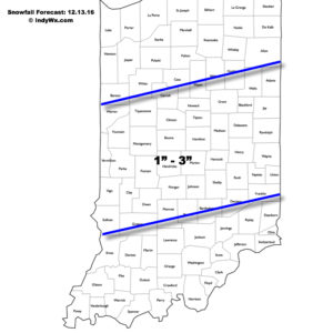
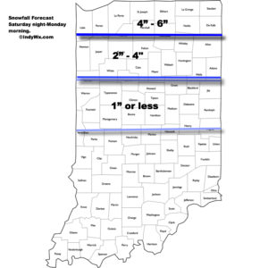
Accumulating Snow Event…Upper energy will combine with an approaching arctic front to lead to an accumulating snowfall event for many across central Indiana Tuesday.  We expect snow to increase in coverage and intensity just prior to sunrise before turning moderate to briefly heavy from mid to late morning on into the early afternoon hours.  In general, we paint a band of 1″-3″ through the heart of central Indiana, but do have some concerns localized banding features could result in a 4″ pop here and there (impossible to pinpoint the precise locations these bands may set-up across central IN as of this update).  Expect a messy morning commute.

121316snowfallforecastFresh arctic air will pour into the region tomorrow evening, along with a gusty NW wind.  Tuesday’s snow should be rather wet in nature so we don’t anticipate blowing/ drifting issues to result as the arctic hounds roar into town.  However, there will likely be periods of flurries and scattered snow showers as the bitterly cold air arrives in the Wednesday-Thursday time frame and this could lead to light additional coatings in spots.  The big weather story through mid and late week will be the bitter air.  “Air that hurts” is what we’re calling it and wind chill values will approach 20 degrees below zero Wednesday night/ Thursday morning.
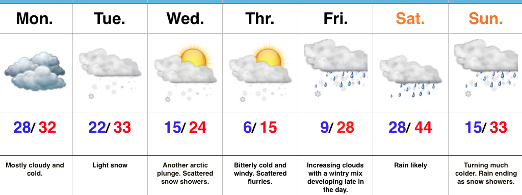
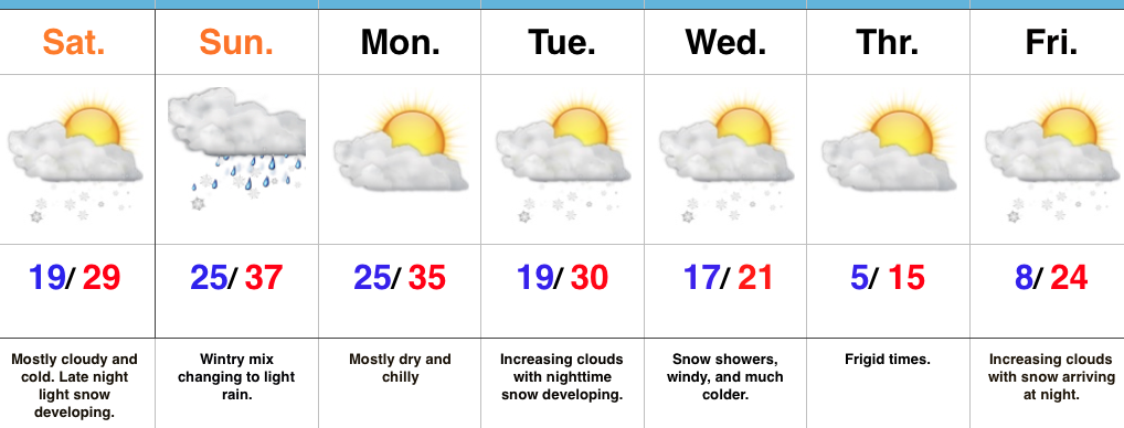
Our next storm system is still slated to arrive for the weekend.  As of now we forecast snow and a wintry mix Friday evening.  This will then change to rain Saturday before arctic air quickly oozes back in here and leads to a potentially messy Saturday night-Sunday morning.  Rain will transition to freezing rain and sleet Saturday evening before ending as a period of snow.  It’s back to the ice box we’ve come to know all too well Sunday into Monday.

Upcoming 7-Day Precipitation Forecast:

  • Snowfall: 2″ – 5″
  • Rainfall: 0.50″

Permanent link to this article: https://indywx.com/2016/12/12/snowy-tuesday-bitter-mid-week-ahead/

VIDEO: Accumulating Snow Tuesday…

You must be logged in to view this content. Click Here to become a member of IndyWX.com for full access.  Already a member of IndyWx.com All-Access?  Log-in here.

Permanent link to this article: https://indywx.com/2016/12/12/video-accumulating-snow-tuesday/

Another Arctic Shot Inbound…

screen-shot-2016-12-11-at-2-49-00-pmHighlights:

  • Even colder this week than last
  • Light snow chances
  • Bigger storm next weekend

Bitterly Cold Week Ahead…We’ll kick off the work week with mostly dry, but mostly cloudy and continued cold conditions.  Be careful if traveling early in the morning as some refreezing may take place across central IN during the overnight.

Reinforcing arctic air will begin to blow into town mid week and an area of light snow may precede this next arctic punch to the gut Tuesday.  Scattered snow showers and flurries will fly in the bitterly cold, arctic, air mass Wednesday and Thursday.  Along with highs only in the teens Thursday, expect below zero wind chills.

Eyes will then shift to the end of the week as our next storm of significance approaches.  This storm appears to be stronger than this past weekend’s system, but similar to this weekend’s overall pattern, we expect a “mild up” and mostly a liquid event across central parts of the state.  The primary reason?  Lack of high latitude blocking to keep the storm track south (more on that in another post later tonight or Monday).  Add in a “feisty” southeast ridge that keeps flexing it’s muscle and you have the makings for what’s likely another cutter to the Lakes.  Unlike this current event, we will have to keep an eye on a potential second wave of moisture moving along the front Sunday as the arctic air returns.

Upcoming 7-Day Precipitation Forecast:

  • Snowfall: 1″ – 2″
  • Rainfall: 0.75″ – 1.00″

Permanent link to this article: https://indywx.com/2016/12/11/another-arctic-shot-inbound/

Busy Winter Pattern Continues…

screen-shot-2016-12-10-at-8-24-08-amHighlights:

  • Snow arrives tonight for central; northern parts of the state
  • Even colder air coming
  • Pattern of storms and rumors of storms

Snow Develops Tonight…Today is mostly dry and cold, including a mostly cloudy sky.  Clouds will lower and thicken this afternoon and give way to light snow late tonight across north-central Indiana and points north.  As milder air is pulled north Sunday, snow will transition to a wintry mix and eventually a cold light rain across central Indiana.  Further north, this will remain mostly snow before transitioning to a wintry mix.  Precipitation will end for everyone Sunday night.

Here’s the current thinking on storm total snowfall with this event. (Click to enlarge).

snowfallmap121116We’ll open the work week with dry and cold conditions, but all eyes will be on the next arctic front by this time.  It’ll blast through here the middle of the week with even colder air than what we’re currently “enjoying.” 🙂  Expect sub-zero wind chills mid week.  Snow showers and gusty winds remain in the mid week forecast and will require fine tuning as we draw closer.  A quick note, medium range modeling and beyond will really struggle in run-to-run consistency with such a pattern.  The slightest difference in handling respected upper air energy will lead to dramatic changes in the sensible weather the modeling paints.  There’s no sense in changing the forecast daily (or, in some cases, multiple times per day, only to change it back to where we began as time draws closer).
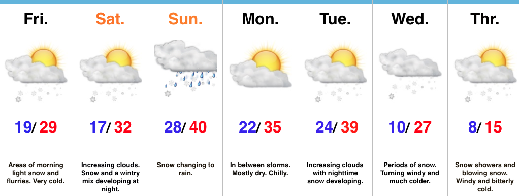
Finally, yet another winter weather maker awaits for the end of the week.  Clouds will be on the increase Friday with snow (or a wintry mix) developing at night.  It’s a busy, cold pattern…

Upcoming 7-Day Precipitation Forecast:

  • Snowfall: 1″ – 3″
  • Rainfall: 0.10″ – 0.25″

Permanent link to this article: https://indywx.com/2016/12/10/busy-winter-pattern-continues/

Buckle Up; Active Winter Pattern Is Only Beginning…

screen-shot-2016-12-09-at-7-32-12-amHighlights:

  • Very cold with snow showers diminishing
  • Messy second half of the weekend
  • Awaiting our next storm mid week
  • Frigid air awaits

Wintry Hits Are Lining Up…Fresh arctic air combined with even the slightest bit of upper energy can produce an overachieving snow shower event. As was the case overnight with many neighborhoods through central IN accumulating a coating to around 1″ of snow.  Take it slow this morning and leave extra time to reach your destination.  Bitterly cold air continues to wrap up the work week and head into the weekend (keep in mind our average high and low are in the lower 40s and middle 20s, respectfully).  As we look through the upcoming 7-day period, temperatures will run significantly below average throughout.

Our next storm system is dialed up this weekend.  Clouds will increase as we progress through the second half of the day Saturday and light snow will develop late Saturday night into Sunday morning.  As the area of low pressure tracks from northern MO into the Great Lakes, we’ll get into a milder southerly flow Sunday.  This will help bring in enough warm air to transition snow to rain during the day Sunday.  Beforehand, a light accumulation of snow is possible in and around Indianapolis (more on potential amounts this time tomorrow).  Heavier snow will pile up across northern Indiana.  Precipitation should shut off rather quickly Sunday night and we’ll be in between systems Monday.

By Tuesday, our attention will turn northwest as we await the arrival of another arctic cold front.  As the front moves in, modeling suggests multiple waves of energy move along the boundary, throwing moisture into the cold air and creating a rather snowy scenario as we progress through mid week.  We need to get through the weekend first, but this could also be an impactful event.  Very windy and frigid conditions move in Wednesday into Thursday, including sub-zero wind chills.  Additional snow chances await next weekend…

Upcoming 7-Day Precipitation Forecast:

  • Snowfall: 2″- 5″
  • Rainfall: 0.25″ – 0.50″

Permanent link to this article: https://indywx.com/2016/12/09/buckle-up-active-winter-pattern-is-only-beginning/

Busy Winter Pattern…

screen-shot-2016-12-07-at-7-59-56-amHighlights:

  • Arctic air blows in tonight
  • Winter storm potential this weekend
  • Another blast of arctic air next week

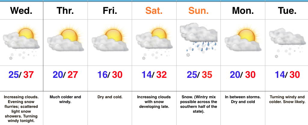
Busy Times Ahead…The fun and active winter pattern has arrived and will keep us forecasters on our toes as we go through the next couple weeks.  Early sunshine will give way to an increasingly cloudy sky this afternoon and a couple snow flurries or scattered light snow showers may precede the arctic plunge this evening.  Snow lovers, unfortunately the arctic wave didn’t materialize as we once thought.  (Hang in there, you have many more snow opportunities ahead).  We’ll turn windy tonight and wind chills will fall into the single digits by Thursday morning.  We’ll stay dry, but cold to wrap up the work week.

Eyes will then shift to the weekend as a developing storm system pushes snow into the region Saturday night.  Snow and/ or a wintry mix will continue Sunday.  Where this remains all snow, it’s likely to be a “plowable” event.  We still need to fine tune the details over the next couple of days to hone in on just where the mixing line will set up.  Thinking now is that from Indianapolis and points north, this is mostly a snow event, but stay tuned.

Another round of snow and wind will blow into town early next week.  This will likely be ahead of an even colder push of air by the middle part of next week.

Upcoming 7-Day Precipitation Forecast:

  • Snowfall: 3″ – 5″
  • Rainfall:  0.10″ – 0.25″

Permanent link to this article: https://indywx.com/2016/12/07/busy-winter-pattern/

Arctic Air Inbound…

screen-shot-2016-12-05-at-11-19-01-pmHighlights:

  • Morning showers
  • Snow showers late tomorrow night
  • Arctic air arrives
  • Weekend storm system

Find That Heavier Winter Gear…Our next area of low pressure will push northeast between now (north-central Gulf Coast) and Tuesday night (central Appalachians).  Most of the widespread rain will fall across southeast IN this go around, but enough moisture will spread west to result in scattered to numerous showers Tuesday morning.  With temperatures in the lower to middle 30s, don’t be surprised if a sleet pellet or snow flake mix in at times.  All in all, expect another “raw” day.  Drier times will await for the evening rush home.

Wednesday will feature mostly dry conditions, but the arctic hounds will be howling to our northwest.  Snow showers will precede this arctic blast Wednesday night and Thursday morning and may be enough to accumulate for some.  While models remain drier than we’d expect (given the overall set-up), we may “eek” out just enough moisture to coat the ground up for some. Thursday will be a frigid day, including wind chills in the single digits.  Heavier winter gear will be required to wrap up the work week.

The weekend features more “fun and games” as an area of low pressure attacks stale cold air left over from the late week arctic push.  Is the cold air deep enough to create wintry problems or does the southerly flow help scour out the chill and lead to more of a liquid event.  Stay tuned.

Upcoming 7-Day Precipitation Forecast:

  • Snowfall: 1″ – 3″
  • Rainfall: 0.50″

Permanent link to this article: https://indywx.com/2016/12/05/arctic-air-inbound/

IndyWx.com