Category: Forecast

Changeable Weather This Week…

Mon.

Tue.

Wed.

Thr.

Fri.

Sat.

Sun.

 Status-weather-clouds-icon

 Status-weather-showers-day-icon

 Status-weather-clouds-icon

 Status-weather-clouds-icon

 Status-weather-showers-day-icon

 Status-weather-clouds-icon

 Status-weather-clouds-icon

19/ 43

30/ 56

35/ 50

30/ 51

42/ 65

30/ 45

22/ 37

– – –

Light

– – –

– – –

Light

– – –

– – –

Forecast Updated 03.17.14 @ 12:00p

Quiet, Brighter Start To The Work Week. . .After a “ridiculously” cold, windy, and gloomy Sunday, it’ll be nice to see the sunshine return as we kick off another work week.  Temperatures will remain much colder than average, but with that late March sun working through later this afternoon (once these pesky clouds move east), it’ll feel somewhat better.

Fast Moving Storm System. . .Most of Tuesday will be sunny and dry, but a frontal boundary will race towards central Indiana Tuesday evening and we note some of our high resolution model data trying to bring a thin line of showers and thunderstorms through in association with this frontal passage.  After a mainly dry day, clouds will increase and we’ll forecast quick-moving showers and embedded thunder Tuesday night into Wednesday morning.  Rainfall amounts will remain light.

Dry, blustery weather will return Wednesday afternoon with temperatures just a few degrees below normal.

Late Week Storm. . .After a dry and pleasant Thursday, southwest breezes will kick into high gear and allow temperatures to jump into the middle to perhaps upper 60s Friday (dependent upon how much sunshine we see).  That said, another cold front will have it’s eyes set on our area and clouds will increase during the afternoon and evening hours with showers and thunderstorms developing Friday night as the front pushes southeast.

This will then set the stage for another cold weekend ahead.  While we’re trending next weekend (especially Sunday) MUCH colder, it’s possible we’ll have to lower temperatures even further in the days ahead.

Upcoming 7-Day Precipitation Forecast:

  • 7-Day Snowfall Forecast: 0.00″
  • 7-Day Rainfall Forecast:  0.25″

twic

For weather updates and more “behind the scenes” data on the go, be sure to Follow Us on Twitter @indywx or become a Friend of IndyWx.com on Facebook!

images

After a long winter, sunshine and pleasant temperatures provided a great day to get outside and enjoy the conditions last Saturday in Zionsville!  Thanks to John Salewicz for this shot!

photo-2

Permanent link to this article: https://indywx.com/2014/03/16/changeable-weather-this-week/

Much Colder And Very Windy Sunday

The storm system that looked like it may provide central Indiana accumulating snow earlier this week is, indeed, remaining south. Portions of southern parts of the state will see light…

You must be logged in to view this content. Click Here to become a member of IndyWX.com for full access.  Already a member of IndyWx.com All-Access?  Log-in here.

Permanent link to this article: https://indywx.com/2014/03/16/much-colder-and-very-windy-sunday/

Dry Today; Windy And MUCH Colder Sunday…

Sat.

Sun.

Mon.

Tue.

Wed.

Thr.

Fri.

 Status-weather-clouds-icon

 images

 Status-weather-clouds-icon

 Status-weather-showers-day-icon

 Status-weather-clouds-icon

 Status-weather-clouds-icon

 Status-weather-clouds-icon

32/ 52

24/ 30

17/ 42

27/ 54

39/ 50

32/ 53

33/ 62

– – –

– – –

– – –

Light

– – –

– – –

– – –

Forecast Updated: 03.15.14 @ 8:53a

Nice Today; MUCH Colder Sunday. . .Today will easily be the pick of the weekend as mostly sunny skies dominate along with seasonable temperatures.  Get outside and enjoy!

We continue to watch a southern storm system for the second half of the weekend and while model data trended north Thursday, the common theme most of Friday into this morning has been back south.  As such, we’ll lean towards a less snowy forecast Sunday for central Indiana, but note if you have travel plans to the southern third of the state that accumulating snow and ice will greet you Sunday.  Here across central Indiana look for a rather cloudy and MUCH colder day.  In fact, temperatures won’t even make it to the freezing mark with a very strong east to northeast wind in play.  Winds may gust as high as 35 MPH Sunday afternoon, making it feel like the single digits and teens.

Relatively Quiet Week. . .Modeling continues to struggle with the timing and strength of storm systems in the week ahead, but current thinking takes the storm track primarily north of our area next week, meaning less impact (from rain or snow chances) here.  We caution that this can change and we’ll keep a close eye on things, but we’re trending our forecast towards a quieter one for now.  The next system of note will be a fast moving low pressure area and associated cold front that will pass here Tuesday into Wednesday.  A scattered shower and wind shift will occur with this system, but, as stated above, the majority of the more significant “weather” will lie to our north.

A brief warming trend to well above normal temperatures may carry us to close out the work week before the next systems eyes our area later next weekend.

Upcoming 7-Day Precipitation Forecast

  • 7-Day Snowfall Forecast: 0.00″
  • 7-Day Rainfall Forecast: 0.25″

twic

For weather updates and more “behind the scenes” data on the go, be sure to Follow Us on Twitter @indywx or become a Friend of IndyWx.com on Facebook!

images

I know many are saying thankfully we aren’t dealing with this kind of weather today.  After a harsh winter, it’s always nice to see the sunshine and milder temperatures return.  Today we take you back to a snowy Zionsville from February 17th.  This shot was taken by Janet Baker.  Thanks, Janet!

SnowFeb17Zionsville

Permanent link to this article: https://indywx.com/2014/03/15/dry-today-windy-and-much-colder-sunday/

Spring Like Today, But Keeping A Close Eye On Sunday…

Fri.

Sat.

Sun.

Mon.

Tue.

Wed.

Thr.

 Status-weather-showers-day-icon

 Status-weather-clouds-icon

 Status-weather-snow-scattered-icon

 Status-weather-clouds-icon

 Status-weather-showers-scattered-icon

 Status-weather-snow-scattered-day-icon

 Status-weather-clouds-icon

32/ 60

32/ 52

24/ 34

19/ 36

32/ 48

30/ 40

28/ 45

Light

– – –

Moderate

– – –

Light

Light

– – – 

Forecast Update 03.14.14 @ 7:45a

Nice Close To The Work Week. . .A weak frontal system will blow through the region later this afternoon and this may spark a light shower south and east of the city.  All in all, it won’t be a big deal and won’t put a damper on an otherwise beauty of a close to the work week.  Gusty southwest winds will help temperatures zoom into the upper 50s to near 60 for afternoon highs.

Sunday Snow Storm Brewing?  That’s the big question this morning.  Model data continues to trend north and west with this storm system and we’re keeping a close eye on things.  The set up is one that features a late season arctic high over the Great Lakes region Sunday with developing low pressure moving out of Texas and into the TN Valley.  Yes, we’ll have the cold and the moisture…

We know Sunday will be a MUCH colder and windy day, but we’re trending our forecast snowier, as well.  Best chances of snow arrive Sunday afternoon into Sunday night.  While there’s still some question in regards to the northern extent of the snow shield, the northwest trend may not be done just yet.  As a result, we feel central Indiana is very much in play for accumulating snow Sunday afternoon through Sunday night.  Stay tuned.

Another Storm. . .Another storm system will arrive Tuesday into Wednesday and modeling continues to struggle on this event, as well.  We’ll leave the forecast relatively unchanged for Tuesday and Wednesday now.  After we deal with Sunday we’ll be able to get a better handle on the Tuesday/ Wednesday storm system.

Upcoming 7-Day Precipitation Forecast

  • 7-Day Snowfall Forecast: 2-4″
  • 7-Day Rainfall Forecast:  0.25″

twicFor weather updates and more “behind the scenes” data on the go, be sure to Follow Us on Twitter @indywx or become a Friend of IndyWx.com on Facebook!

images

John Salewicz sent in this beautiful panoramic cloud shot from Zionsville Thursday evening.  Thanks, John!

Photo

Permanent link to this article: https://indywx.com/2014/03/14/spring-like-today-but-keeping-a-close-eye-on-sunday/

More Active Changes In Store…

Thr.

Fri.

Sat.

Sun.

Mon.

Tue.

Wed.

 Status-weather-clouds-icon

 Status-weather-clouds-icon

 Status-weather-showers-day-icon

 Status-weather-snow-scattered-day-icon

 Status-weather-clouds-icon

 Status-weather-showers-scattered-icon

 Status-weather-snow-scattered-day-icon

13/ 39

32/ 60

33/ 51

27/ 38

21/ 38

30/ 40

19/ 35

– – –

– – –

Light

Light

– – –

Light

Light

Forecast Updated 03.13.14 @ 7:39a

Thankful For That March Sun…It’ll be a frigid start to your Thursday with many reports of lower teens across the region, including wind chill values around zero.  That said, that strong March sun angle will help temperatures zoom to near 40 with a mostly sunny sky Thursday afternoon.

We’ll do even better than that on Friday, once again with a mostly sunny sky.  We’ll introduce a strong southwest wind into the mix Friday, but this will be a warmer breeze so we’ll take the trade off, right?!  Needless to say, we’ll wrap up the work week with beautiful conditions!

Colder Weekend; Watching A Southern Storm…After another mostly pleasant Saturday, a cold front will blow through here Saturday afternoon.  At the same time, we’ll keep our eyes on a developing wet southern storm system.  Latest guidance keeps this storm south of our region, but we’ll keep an eye on things.  A light shower is possible Saturday morning.  Colder air will blow into town Saturday night and Sunday.

Headaches Next Week…Model solutions vary wildly for next week.  Case in point, the Wednesday afternoon run off the powerful European forecast model suggests a snow storm and cold conditions Tuesday into early Wednesday.  All the while, the GFS takes the storm along the Canadian border and results in a much warmer and drier solution here with highs near 60.  We’re leaning more towards the European in this situation, but not fully buying in just yet to the locked and loaded snow storm solution.

It’s important to note the GFS operational run doesn’t agree with it’s own ensembles so this is one of the main drivers with us at least “leaning” more towards the European solution at this juncture.  We’ll make sure that we keep a close eye on the Tuesday-Wednesday period and update accordingly.  For now we’re going with a rain-to-snow situation Tuesday with potentially accumulating snow falling Tuesday night into early Wednesday.

* This morning we note the European is onto a warmer solution, as well, but before we change our forecast all over the place, we prefer to look over afternoon data and will update things accordingly later this evening for next week.

Upcoming 7-Day Precipitation Forecast:

  • 7-Day Snowfall Forecast: 1-3″
  • 7-Day Rainfall Forecast: 0.25″

twic

For weather updates and more “behind the scenes” data on the go, be sure to Follow Us on Twitter @indywx or become a Friend of IndyWx.com on Facebook!

images

Permanent link to this article: https://indywx.com/2014/03/12/more-active-changes-in-store/

Downright Spring Like Today Gives Way To A Snowy Wednesday.

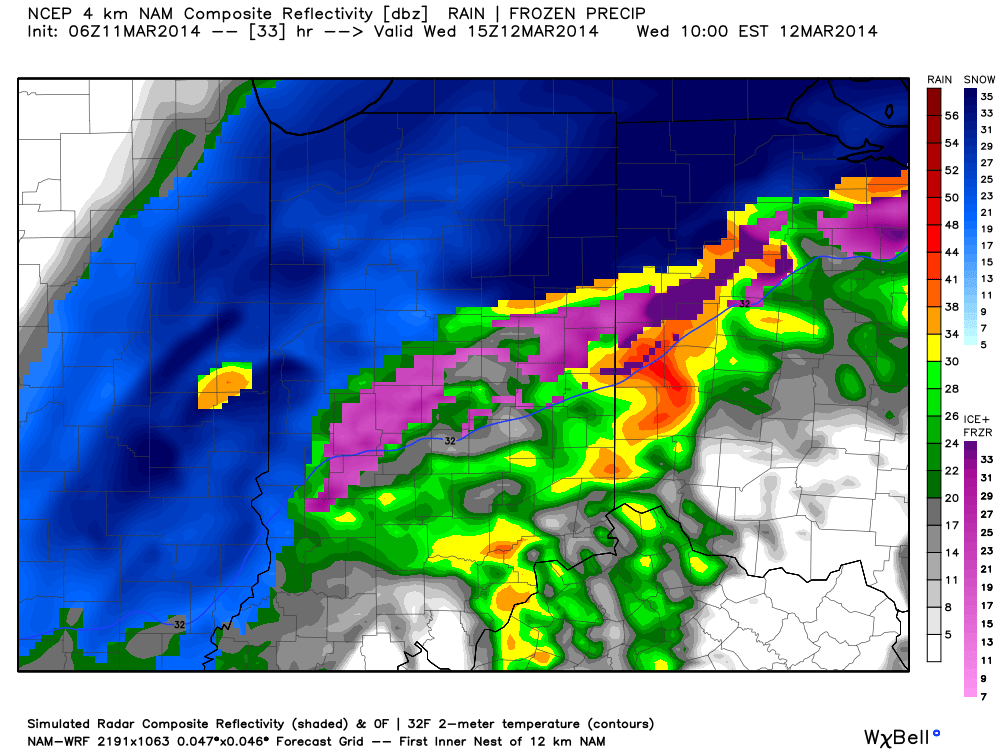
Good morning, Indy!  While we’ll reach the warmest temperatures of the year, so far, today (lower to middle 60s across central Indiana), we continue to monitor the goings on for accumulating snow on Wednesday.

The latest high resolution data shows rain changing to snow during the morning Wednesday across our area- between 7 and 9 o’clock from north to south:

hires_ref_indy_34

Here are some quick bullet point thoughts and we’ll have a more complete update posted this evening:

  • Rain changes to snow between 7-9a from north to south
  • Period of heavy snow falls from 10a to 1p
  • Gusty northeast winds will approach 40 MPH resulting in blowing and drifting where snow accumulates
  • Going accumulation idea remains unchanged for now- 2″ or less for the city and points south; 2-5″ north of the city. Heaviest snowfall will be laid down across northern Indiana where amounts over 8″ are likely.

Permanent link to this article: https://indywx.com/2014/03/11/downright-spring-like-today-gives-way-to-a-snowy-wednesday/

Spring Tease Through Tuesday; Back To Winter Wednesday.

Mon. Tue. Wed. Thr. Fri. Sat. Sun.               34/ 60 40/ 63 18/ 40 10/ 35 27/ 53 32/ 49 28/ 40 Light –…

You must be logged in to view this content. Click Here to become a member of IndyWX.com for full access.  Already a member of IndyWx.com All-Access?  Log-in here.

Permanent link to this article: https://indywx.com/2014/03/10/spring-tease-through-tuesday-back-to-winter-wednesday/

Beauty Of A Close To The Work Week…

Fri.

Sat.

Sun.

Mon.

Tue.

Wed.

Thr.

 Status-weather-clouds-icon

 Status-weather-showers-scattered-icon

 Status-weather-clouds-icon

 Status-weather-clouds-icon

 Status-weather-clouds-icon

 Status-weather-snow-scattered-icon

 Status-weather-clouds-icon

21/ 53

30/ 46

21/ 45

33/ 60

40/ 61

21/ 40

13/ 32

– – –

Light

– – –

– – –

– – –

Light

– – –

Forecast Updated 03.07.14 @ 7:30a

Get Outside & Enjoy…We’re going to wrap up the work week with beautiful conditions.  If you can get out of work or school early today, IndyWx.com highly recommends it :-)!  High pressure will support sunny skies (after a little morning fog in spots) and milder temperatures.  Highs will zoom into the lower to middle 50s this afternoon!

Weak Weekend System…A weak cold front will slip south through the region Saturday.  Early morning sunshine will quickly give way to increasing clouds and developing light rain.  Rain will end as a period of light snow Saturday evening, but won’t accumulate.  The key word in all of this is light, with rainfall totals under a tenth of an inch.

Sunday will be a dry, chilly day with highs in the middle 40s.

True Spring Feel…The spring crave will be in full effect early next week as highs both Monday and Tuesday shoot into the lower 60s with sunshine.  We’ll notice a gusty westerly breeze Monday, assisting with the milder surge of air into the Ohio Valley.

Late Season Winter Storm Brewing?  Many questions remain around the ultimate track of the storm system by the middle of next week.  As of now, a blend of forecast model suggests a rain-to-snow scenario Wednesday, but it’s far too early to talk accumulations.  We’ll be able to fine tune some things over the weekend and have a better idea soon in regards to precipitation type and amount.  Regardless, a much colder air mass will pour into the region by the middle of next week.

Upcoming 7-Day Precipitation Forecast:

  • 7-Day Snowfall Forecast: 1-3″
  • 7-Day Rainfall Forecast: 0.10″ – 0.25″

twic

For weather updates and more “behind the scenes” data on the go, be sure to Follow Us on Twitter @indywx or become a Friend of IndyWx.com on Facebook!

images

Permanent link to this article: https://indywx.com/2014/03/07/beauty-of-a-close-to-the-work-week/

Spring Tease In The Midst Of A Cold Pattern…

Wed.

Thr.

Fri.

Sat.

Sun.

Mon.

Tue.

 Status-weather-snow-scattered-day-icon

 Status-weather-clouds-icon

 Status-weather-clouds-icon

 Status-weather-snow-scattered-icon

 Status-weather-clouds-icon

 Status-weather-clouds-icon

 Status-weather-clouds-icon

17/ 32

19/ 40

25/ 55

30/ 43

25/ 44

32/ 56

39/ 56

Light

– – –

– – –

Light

– – –

– – –

– – –

Forecast Updated 03.05.14 @ 7:15a

Snow Weakens As It Pushes South…What will look like an impressive shield of snow across northern IL and IN this morning will weaken dramatically as it pushes south into central Indiana later this evening.  The primary reason?  A very dry air mass in place.  That said, we’ll continue to include scattered snow showers and light snow in our forecast, especially north of I-70 this evening.  Many won’t see any sort of accumulation, but a couple reports of a coating of snow will be possible north.  It’ll remain much colder than normal.

Moderating To Finish The Work Week…Dry conditions will return to wrap up the work week along with a warming trend.  By the time we reach Friday, we’ll actually be above normal!  Combine that with a sunny sky and we’re looking at an absolutely gorgeous close to the work week.  Plan to get out and enjoy!

Weak Weekend System…A cold front will move south through the region and be responsible for returning the area to a chillier regime over the weekend, along with a possible light snow Saturday.  Light is the key word and we’re not looking at any accumulation of significance.  Sunday returns the dry theme as we “jump ahead” an hour.

Spring Tease…Though we’re still locked in a predominately colder than normal weather pattern, that won’t stop us from enjoying a much deserved spring tease early next week.  Both Monday and Tuesday will feature highs in the middle to upper 50s with sunshine!  Definitely well deserved, indeed!

Upcoming 7-Day Precipitation Forecast

  • 7-Day Snowfall Forecast: Less than 1″
  • 7-Day Rainfall Forecast: Less than 0.10″

images

For weather updates and more “behind the scenes” data on the go, be sure to Follow Us on Twitter @indywx or become a Friend of IndyWx.com on Facebook!

twic

Permanent link to this article: https://indywx.com/2014/03/05/spring-tease-in-the-midst-of-a-cold-pattern/

Cold Pattern Continues…

Tue. Wed. Thr. Fri. Sat. Sun. Mon.               5/ 32 17/ 36 20/ 39 24/ 52 29/ 39 20/ 38 29/ 53 – –…

You must be logged in to view this content. Click Here to become a member of IndyWX.com for full access.  Already a member of IndyWx.com All-Access?  Log-in here.

Permanent link to this article: https://indywx.com/2014/03/03/a-record-cold-start-possible/

IndyWx.com