Quiet time will be short-lived as a new winter storm system begins to impact the region as early as tonight, continuing into Tuesday. The Set-Up: An arctic cold front and…
You must be logged in to view this content. Click Here to become a member of IndyWX.com for full access. Already a member of IndyWx.com All-Access? Log-in here.
Bitter Feel; Gearing Up For More Snow…Saturday night’s storm system “split” into two and took one swath of snow across far NW IN while a second (more widespread) area of snow was laid down across central IN. Reports into the forecast office this morning indicate 2″-3″ are common across central IN, with a couple 4″ reports. Thank you for all of the snow reports and photos!
While the snow has stopped, we’ll deal with bitterly cold air and blowing snow the rest of the day. Bundle up and take it slow as you venture out. Temperatures will continue to fall into the teens and wind chill values will fall into the single digits to around zero.
Dry and cold conditions will be with us as we open the new work week, but our next weather maker will blow into town late Monday night and Tuesday morning. We still think intense snow bursts will accompany arctic reinforcements that will send temperatures below zero for some Wednesday morning. It won’t take a lot of moisture to “fluff up” 1″-3″ Tuesday morning. Couple that with gusty winds and falling temperatures and things will likely be messy on area roadways.
Looking ahead, a weak weather system will skirt the area to our north Thursday and could offer up a scattered snow shower, but it’s as we look towards next weekend that things become “more interesting.” Model specifics disagree at this time, but the overall pattern is one that’s conducive to lead to a fairly widespread interior winter storm threat. We’ll have to sort through the details as we go through the week. Stay tuned.
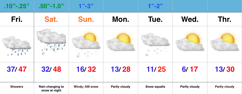
Rain To Snow Late Tonight…Most of today will be mild, but big changes will take place tonight as cold air whips around an area of low pressure that will deliver rain, especially the second half of the day. With the colder air moving in, rain will change to snow overnight and stick in spots. Timing the changeover is key in obviously determining snow amounts, but after looking over morning data, we feel as good as we can about our initial snowfall map issued last night. Additional fine tuning may be required later today, and bust potential remains high.
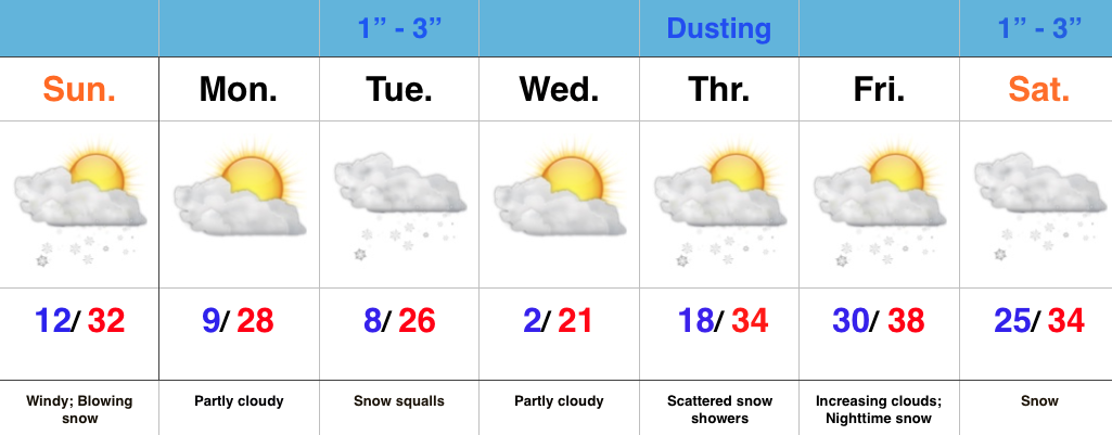
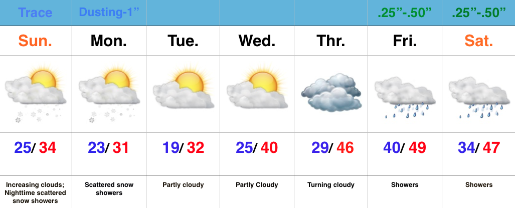
The second half of the weekend will feature morning snow along with strong and gusty north winds. It’ll be a harshly colder day (don’t let that high around freezing fool you, as that will take place around midnight).
Monday will dawn very cold, but dry, but the quiet times will be brief. Clouds will increase late day and snow will develop Monday night into Tuesday morning. Embedded heavy, quick-hitting, snow squalls will accompany arctic reinforcements Tuesday morning and set up a messy morning commute.
A third snow maker is possible Thursday and then our attention turns to next weekend for additional wintry “fun and games.” Get the idea now that we’re in a drastically different pattern when compared to December?
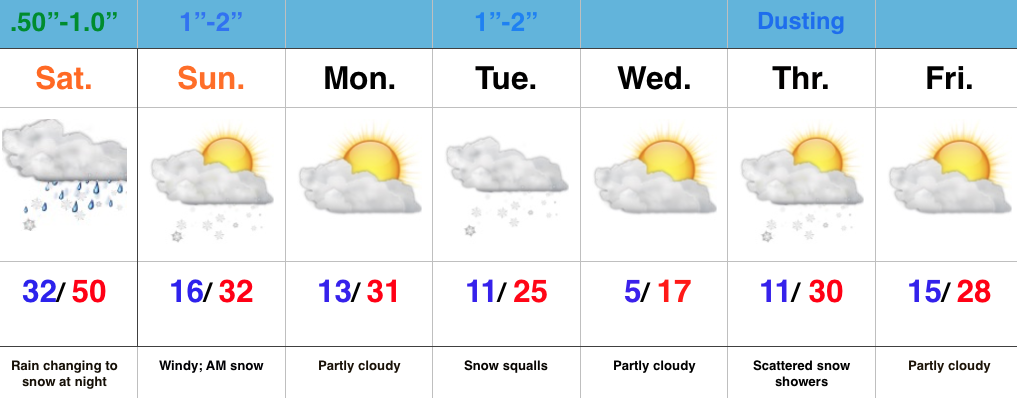
Wet Close To The Week; Winter Blows In To Town…The region will deal with two storm systems as we go through the next few days. Today’s area of low pressure will be responsible for pushing rain showers through the state and while it won’t rain the entire day, it’ll be wise to keep the rain gear nearby.
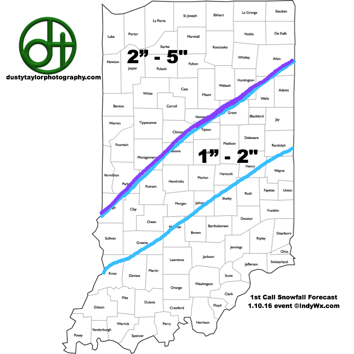
A secondary area of low pressure will lift northeast Saturday into Saturday night. Heavier rains will arrive into central IN Saturday afternoon and the precise track of this second area of low pressure is key in determining the transition from rain to snow as cold air arrives on the scene. As of now, we’ll focus on a changeover overnight Saturday night/ Sunday morning. Initial thinking paints a 1″-3″ swath across central IN, but before issuing our first snowfall map, we want to have an opportunity to see the complete 12z model suite.
Regardless of how much snow falls Sunday morning, expect a much colder feel and strong and gusty winds as we go through the second half of the weekend. Arctic reinforcements arrive Tuesday and we’ll know it. Expect snow squalls and bitterly cold air for mid week.
Looking ahead, busy times continue down the road. An early look at next weekend shows a pattern plenty capable for renewed wintry “fun and games…”
Cold Shot On Deck; Snow Showers To Develop…Our Sunday is dawning with sunshine across central IN, but we note a low cloud deck sinking south and this will engulf all of the region by afternoon. Snow showers will begin to fall across the area by tonight and continue into Monday, and this is showing up well on our high resolution forecast radar, courtesy of Weatherbell.com.
We note the best chances of snow showers will favor the eastern half of the state as lake moisture gets involved. Speaking of that, accumulations of a dusting to an inch will be possible across east-central IN with higher amounts north in the snow belt (3-6″ amounts with a Lake Effect Snow Advisory in effect). You may want to leave extra travel time for your Monday morning commute.
Our mid week stretch will be dominated by a quiet couple of days as high pressure shifts east and we get into a return (milder) SW flow.
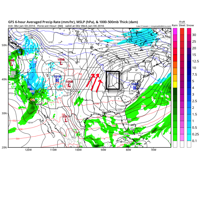
Source: Tropicaltidbits.com
Our next storm system approaches late week and will result in increasing cloudiness and showers developing by Friday, continuing into Saturday.
All eyes will then remain locked in on the 11th-13th time frame for potential wintry “mischief.” There remain many more questions than answers concerning winter storm potential, but confidence continues to increase on a very cold blast of air around, or just before, mid month. Stay tuned!