Category: Forecast

Record Warmth Coming; Rain And Storms As Well…

Screen Shot 2015-12-09 at 7.13.26 AMHighlights:

  • Warmth is the big story now
  • Showers and t-storms increase

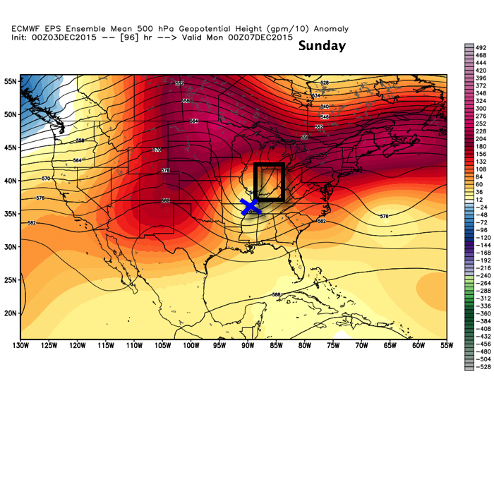
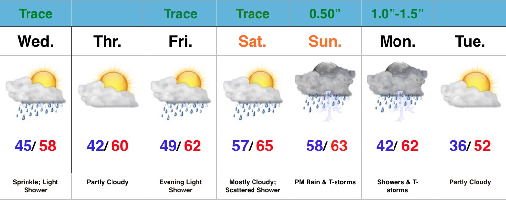
Relatively quiet weather remains in the near-term period.  A fast moving disturbance will cross the state this morning and could spark a light shower or sprinkle, but we’ll get back to increasingly sunny conditions this afternoon and evening.

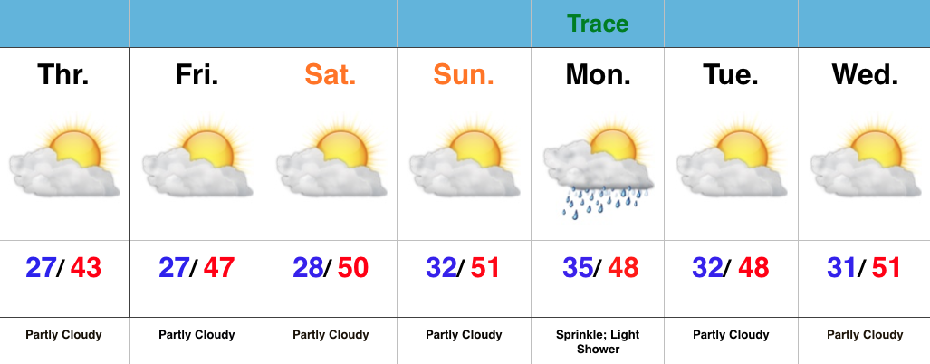
Moisture will begin to return as we close the week and head into the weekend, but it’s really not until the second half of the weekend that we begin looking at more widespread rain.

As a SW flow begins to transport Gulf of Mexico (GoM) moisture north, a light passing shower is possible Friday evening and Saturday.

Friday

Saturday

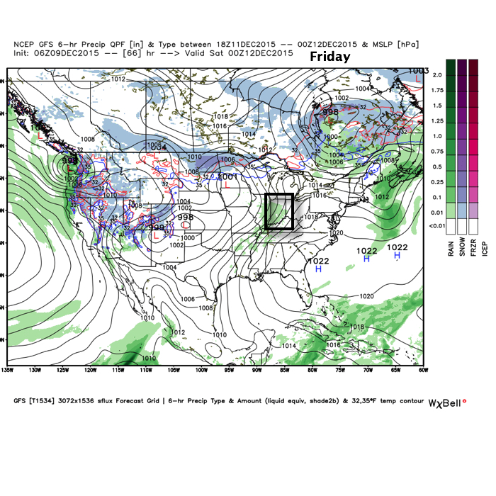
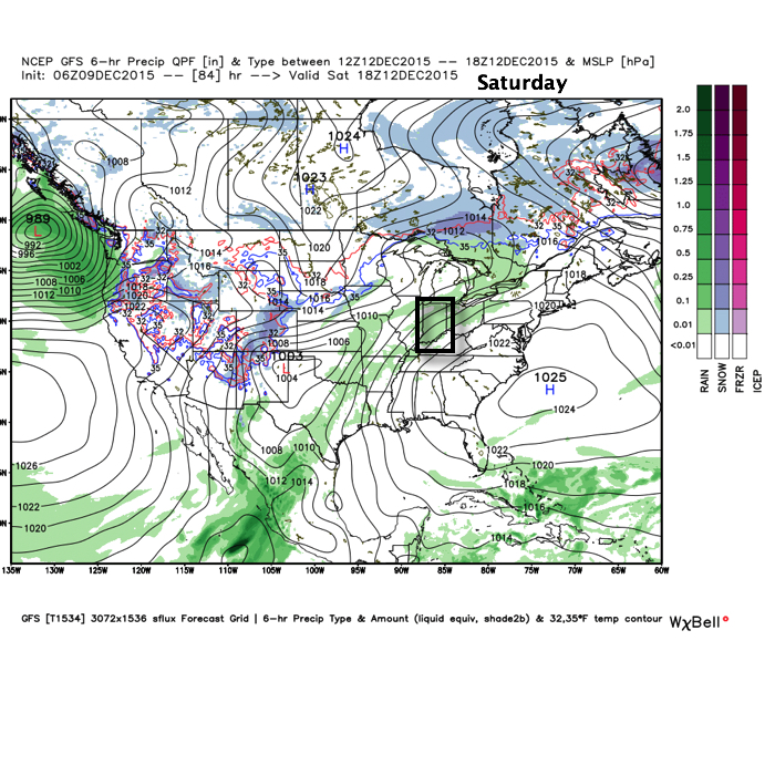
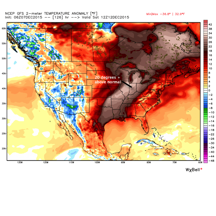
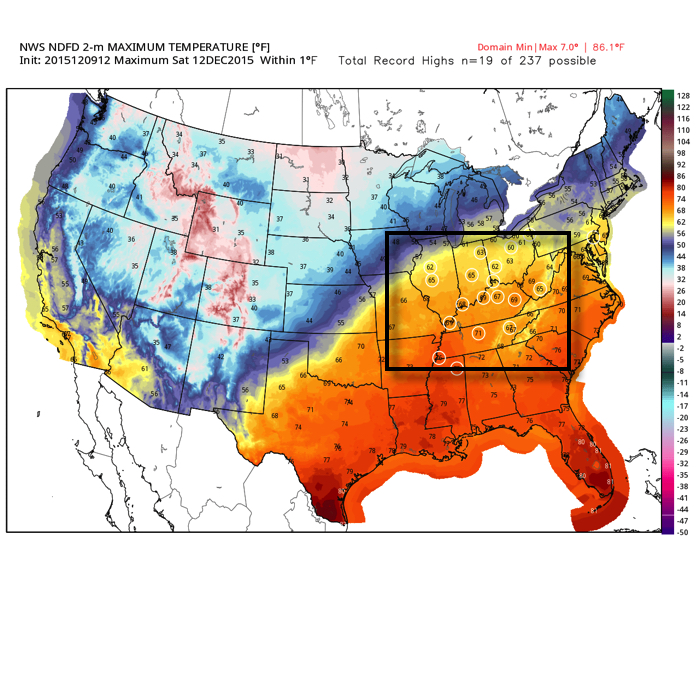
Despite the increase in cloudiness and threat of a passing shower, it won’t keep us away from flirting with records Saturday, and note the widespread portion of the Tennessee and Ohio Valley that will also be in jeopardy of setting new records.

Source: Weatherbell.com

Source: Weatherbell.com

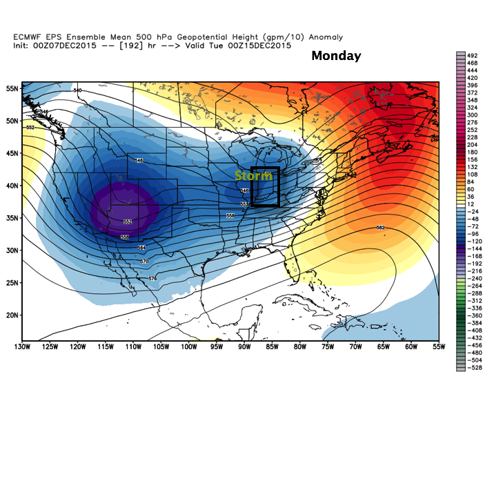
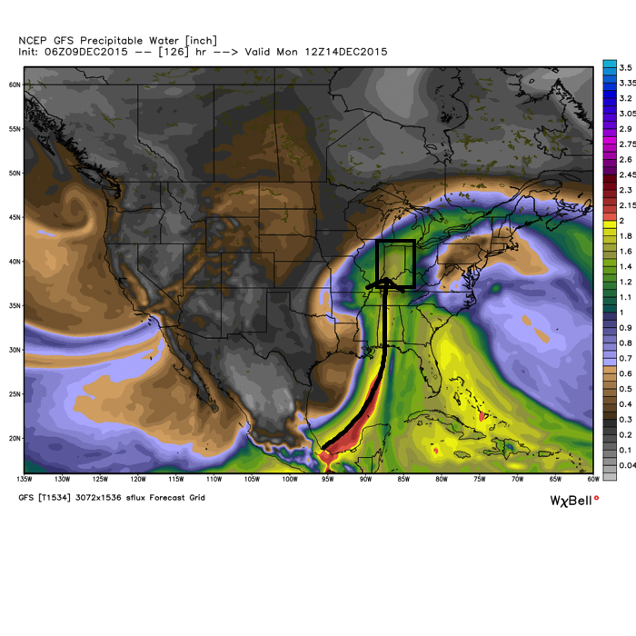
Much better rain and storm chances ramp up Sunday afternoon into Monday.

PWATs (precipitable water values) increase dramatically during the aforementioned time period and could help fuel locally heavy rains during that time period, particularly with embedded thunderstorms.

PWAT

Cooler air will arrive early next week, but remain significantly above normal.  We’ll discuss the longer range a bit later…

Permanent link to this article: https://indywx.com/record-warmth-coming-rain-and-storms-as-well/

What Season Is This? Active Pattern Develops…

Screen Shot 2015-12-07 at 7.31.39 AMHighlights:

  • AM fog gives way to sunshine
  • Another fast moving disturbance moves through Tuesday night-Wednesday
  • Major warmth
  • Stormy finish

A quick glance at the updated 7-day shows two things, a lack of cold air and a rather active time of things.  In the near term, it remains a relatively quiet period.  We’ll deal with morning fog in spots this morning (especially north-central IN) and another fast moving disturbance in the Tuesday night-Wednesday time frame.

The big story as we move into the back half of the week is the unseasonably warm regime that will have many asking “What season are we in?”  We’ll aim for the upper 50s Thursday, around 60 Friday, and upper 60s Saturday as a strong SW flow develops in advance of our next storm system

Warmth will reach it's peak Saturday. Source: Weatherbell

Warmth will reach it’s peak Saturday. Source: Weatherbell

While a scattered, fast moving, shower is possible Saturday, the big story will be the warmth and a gusty SW breeze.

Our storm system will grow closer Sunday and we’ll ramp up rain and storm chances accordingly during that period.  Our two most trusted global models handle things differently as we progress into the Sunday-Monday time frame (strength, track, and timing), and we’ll need to continue to fine tune that particular period as we move forward.  As it stands now we’ll forecast rain and thunderstorms to become widespread Sunday before colder air arrives on the backside of the storm. Stay tuned.

SundayMap

MondayMap

Permanent link to this article: https://indywx.com/what-season-is-this-active-pattern-develops/

Happy Weekend…

Screen Shot 2015-12-04 at 10.01.21 PMHighlights:

  • Freezing Fog
  • Tracking Two Upper Air Disturbances
  • Mild Finish To Next Week

In the short-term, “dirty” high pressure will remain in control of our weather as we welcome in the weekend.  We label this a “dirty” high as a local inversion has resulted in plenty of low clouds and fog over the past couple days, despite high pressure being overhead.  Unfortunately,  the weekend will get off to a similar gloomy, foggy start.  With temperatures below freezing overnight and Saturday morning, areas of freezing fog can once again be anticipated.  Take it slow if you must be out and about early Saturday.  We keep our fingers crossed that we’ll be able to mix things up just enough to allow for at least some sunshine come afternoon.

The upcoming week will feature two upper air disturbances tracking across the state.  One comes Monday and the second arrives Wednesday.  Both will offer up an increase in cloudiness and a light shower chance.

Monday's 500mb chart shows the first of two upper air disturbances set to cross the state. Source: NCEP

Monday’s 500mb chart shows the first of two upper air disturbances set to cross the state. Source: NCEP

Another upper air disturbance will offer up shower chances Wednesday. Source: NCEP

Another upper air disturbance will offer up shower chances Wednesday. Source: NCEP

Once we get to late next week, a southwesterly air flow will take control and pump unseasonably warm air into the Mid West and Ohio Valley.  The mild air will be out ahead of an approaching storm system next weekend and we still anticipate changes as we progress into mid month…

Permanent link to this article: https://indywx.com/happy-weekend/

Extended Stretch Of Quiet Weather Now…

Screen Shot 2015-12-03 at 7.13.36 AMHighlights:

  • Moderating temperatures into the weekend
  • Quiet weather
  • Weak system early next week

In the short-term there’s no reason to waste a lot of pixels (of your time :-)) with the forecast.  High pressure will build in for a very quiet time of things as we head into the first weekend of December.

A weak weather system (upper air disturbance), noted below on the European ensembles, will move through the area in the Sunday afternoon-Monday time frame.  Moisture will initially be limited with this system, but we’ll include mention of a light shower/ sprinkle in association with this.  Eventually, this upper air energy will help energize a storm system along the east coast early next week.

SundayWe still target mid and late month for a flip towards a much more active pattern around these parts…

Permanent link to this article: https://indywx.com/extended-stretch-of-quiet-weather-now/

Sunshine Returns (Finally); Wednesday Snow Showers…

Screen Shot 2015-12-01 at 7.09.18 AMHighlights:

  • Sunshine returns
  • Rain and snow showers Wednesday
  • Extended period of dry weather coming with a moderating trend

Showers raced through central IN during the overnight, but those are now long gone and clouds are beginning to decrease from west to east across the state.  All-in-all, a very nice Tuesday, and first day of December, is on the way!

Enjoy it, as Wednesday’s weather will be much more like you’d expect around this time of the year.  Clouds will increase late tonight and give way to mixed rain and snow showers, particularly Wednesday afternoon and evening.  This is in association with the area of low pressure, currently impacting MN with snow, that will slowly move east into the Great Lakes.

Wednesday

WedEveningOur cold and wintry “set back” will be short-lived as we get into an extended stretch of dry and milder weather heading into the weekend.  The culprit?  An expanding ridge across the northern tier.

FridayThis ridge looks to remain in control of our weather through early to middle next week before our next storm system may impact the region.

Permanent link to this article: https://indywx.com/sunshine-returns-finally-wednesday-snow-showers/