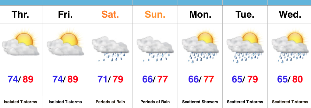
Central Indiana is enjoying some needed “down time” in the rainfall department this evening, but this won’t last as rain coverage and intensity returns overnight and Sunday morning. Like today, locally heavy downpours will be likely.

Forecast radar at 4a

Forecast radar at 6a.

Forecast radar at 11a.
In looking at early 00z data, it appears as if we deal with (2) waves of rain Sunday:
Sunday morning will feature widespread rain across central Indiana, including localized heavy rain. Another “lull” in the activity will likely arrive Sunday afternoon into the evening hours, but we caution rain and embedded thunder will really begin to ramp up and increase in coverage and intensity yet again late Sunday night into the day Monday.
The second surge of moisture is more in direct association with the tropical moisture and energy moving north. This area of rain will likely include embedded rates of 3″-4″/ hour for some very localized areas. It’s impossible to pin point where these areas are, but don’t be surprised to hear (or see) some very heavy rain Monday.

A true Gulf of Mexico connection will be present Monday and aid in flooding prospects.
When we factor in expected rain from tomorrow and Monday, it would appear as if central IN is in line to accumulate an additional 2″-4″ with locally heavier amounts. Flooding prospects will increase dramatically Monday as heavy rain falls on saturated soils. Please, take warnings seriously. Rapid water rises are likely.

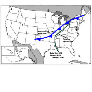 Despite lackluster model output from our American suite (latest NAM and SREF data, for instance, paints rainfall totals under 1″ across most central IN neighborhoods), the European remains consistent on the evolution of things from this weekend into the middle of next week. We’ll lean more towards it’s solution at this juncture. Simply put, when you have a stalled frontal boundary entraining tropical moisture, expect problems. Precipitable water values will approach and even exceed 2″ at times this weekend. Dew points will remain in the upper 60s to lower 70s along and south of the boundary. Where the boundary stalls will be key in determining the heaviest rain totals and resulting flood problems that will ensue. For now, here’s the best idea we have in regards to local 4″+ totals between this weekend and next Wednesday.
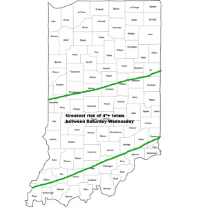 It should also be pointed out that we’re not looking at all day rains Saturday through Wednesday, but instead “waves” of moisture throughout the period. Areas of locally heavy rain will be with us, but we’ll also see dry periods in between. Thankfully, as we move into the latter portions of next week, drier times should return.