Category: Forecast Models

Another “Plowable” Snow Gives Way To Sub-Zero Cold…

With the exception of light lake effect snow showers today (noticing a couple of light bands just west of the city as we write this Saturday morning around 10a), most of today and Sunday will be dry and cold.  We’ll top out around 20° today and Sunday with low temperatures tonight dropping into the 0° to 5° range.

Our next snow maker will arrive late Sunday night into Monday morning in the form of a clipper system.

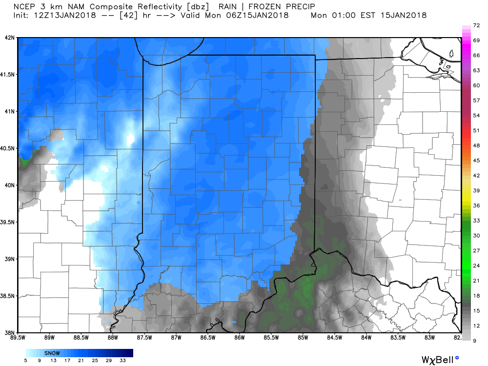
Forecast radar 1a Monday.

We expect light snow Monday morning to grow in overall coverage and intensity through the late morning and into the early afternoon hours.

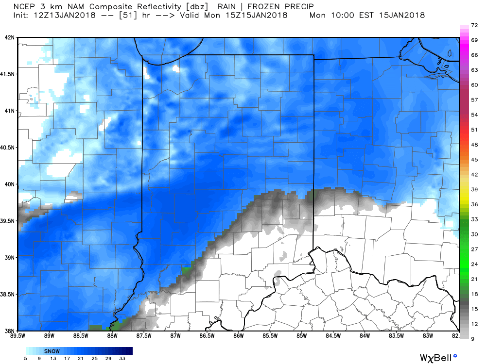
Forecast radar 10a Monday.

Accumulating snow will push off to the south Monday evening.

Forecast radar 7p Monday.

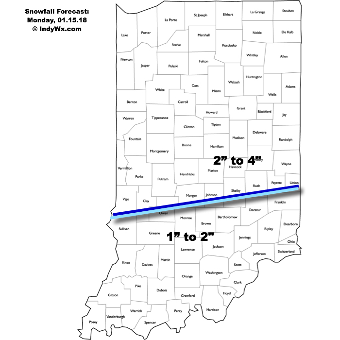
This will be a plowable event for central Indiana and we’ll also have to deal with blowing and drifting concerns Monday afternoon through Monday night as strong and gusty northwest winds arrive.  Needless to say, to our snow removal and DPW crews out there, find a way to get some rest this afternoon and Sunday before another busy stretch to open the work week.  We think additional snowfall of 2″ to 4″ is a good bet across the northern half of the state, with slightly lighter amounts of 1″ to 2″ across southern Indiana.

Arctic high pressure will settle over a growing snowpack to help setup a frigid stretch through early and mid week.  Multiple nights with below zero readings are expected beginning Tuesday morning where most will wake up to readings of 3° to 8° below zero (not counting the wind chill).

Permanent link to this article: https://indywx.com/another-plowable-snow-gives-way-to-sub-zero-cold/

VIDEO: Two Winter Events Impact Central Indiana Between Friday And Monday…

You must be logged in to view this content. Click Here to become a member of IndyWX.com for full access.  Already a member of IndyWx.com All-Access?  Log-in here.

Permanent link to this article: https://indywx.com/video-two-winter-events-impact-central-indiana-between-friday-and-monday/

VIDEO: Brief Thaw Gives Way To A Wintry Close To The Week…

You must be logged in to view this content. Click Here to become a member of IndyWX.com for full access.  Already a member of IndyWx.com All-Access?  Log-in here.

Permanent link to this article: https://indywx.com/video-brief-thaw-gives-way-to-a-wintry-close-to-the-week/

Confidence Growing In Potential Major Winter Storm…

Confidence continues to grow in the prospects of a major winter storm impacting the Mid West and Ohio Valley Friday into Saturday.  A cold front will slip through central Indiana Thursday night, allowing colder air to push back into the state.  At the same time, surface low pressure should begin to organize along the tail end of the frontal boundary across the Ark-la-tex region.  As we progress through the day Friday, cold air will continue to penetrate south into the Ohio Valley while the surface low lifts northeast into the region.  While we can argue about the specific track (this is still a few days out, after all), the pattern supports a central Ohio Valley track as we progress through the day Friday into Saturday.

EPS 500mb ensemble mean Friday

EPS 500mb ensemble mean Saturday

EPS 500mb ensemble mean Sunday

We caution not to get too worked up over individual operational output (including those “spectacular” runs) as run-to-run variance is likely over the next few days.  That said, when we have support from overall pattern techniques that have supported a significant interior event for late this week since last week, along with ensemble agreement, it does lead to greater than normal confidence.  If you have travel plans late this week/ weekend, we suggest keeping a very close eye on the forecast.  This will be a high impact event for portions of the Ohio Valley.

While it’s impossible to say precisely where the heaviest swath of snow is laid down in this situation from a few days out, this is a storm that should carry a swath of 6″ to 12″+ snow just to the northwest of the track.  Additionally, an initial period of an icy mixture of sleet and freezing rain is also possible.  Finally, as the storm wraps up over the Ohio Valley Saturday, a strengthening wind will lead to potential severe blowing and drifting issues.  Fresh arctic air will flow into the region Saturday night into Sunday that will return sub-zero wind chills to the area.

Bottom line, stay tuned…

Permanent link to this article: https://indywx.com/confidence-growing-in-potential-major-winter-storm/

VIDEO: Wintry Mess By Sunday Night; Don’t Put Us In The Winter’s Over Camp…

You must be logged in to view this content. Click Here to become a member of IndyWX.com for full access.  Already a member of IndyWx.com All-Access?  Log-in here.

Permanent link to this article: https://indywx.com/video-wintry-mess-by-sunday-night-dont-put-us-in-the-winters-over-camp/