Category: Forecast Models
-
Filed under 7-Day Outlook, Autumn, Forecast, Forecast Discussion, Forecast Models, GFS, Heavy Rain, HRRR, Rain, T-storms, Unseasonably Cool Weather
-
September 2, 2014
|
Tue.
|
Wed.
|
Thr.
|
Fri.
|
Sat.
|
Sun.
|
Mon.
|
|

|

|

|

|

|

|

|
|
67/ 80
|
60/ 83
|
64/ 87
|
69/ 89
|
55/ 73
|
49/ 73
|
51/ 76
|
Decreasing Rain Coverage; Increasing Sunshine…A shield of moderate to heavy rain encompassed the state during the overnight. This shield of rain is slowly moving east, southeast and we’ll be looking at improving weather through the day. There’s still the chance of a widely scattered thunderstorm late morning or early afternoon as a frontal boundary slides through the region.
Sunny Days…As we progress through the mid and late week stretch, we’ll enjoy dry skies and plentiful sunshine. Normal lows and highs are in the lower 60s and lower 80s this time of year, so we’ll be very close to that Wednesday before moderating temperatures take us warmer than average to wrap up the work week.
Late Week Cold Front; Autumn Feel This Weekend…A cold front will slice into the warm and humid air mass Friday evening and lead to the possibility of a broken line of strong to potentially severe thunderstorms. A MUCH cooler air mass will then invade the region behind the boundary, leading to a true fall-like feel this weekend!
7-Day Precipitation Forecast:
- 7-Day Rainfall Forecast: 0.50″ – 0.75″
- 7-Day Snowfall Forecast: 0.00″
John Salewicz sent us this beautiful sunrise photo Saturday morning before storms invaded portions of central Indiana. Thanks, John!


Are you craving cooler air to go along with that early season pumpkin spice latte? You’ll be in luck this weekend as a true fall-like air mass invades…
Permanent link to this article: https://indywx.com/2014/09/02/improving-weather-through-the-day/
Good morning football fans! Your IndySportsReport.com high school football forecast promises to be a warm and humid one with storm potential… A warm front will lift north through the region…
You must be logged in to view this content. Click Here to become a member of IndyWX.com for full access. Already a member of IndyWx.com All-Access? Log-in here.
Permanent link to this article: https://indywx.com/2014/08/29/muggy-and-potentially-stormy-indysportsreport-com-football-forecast/
As we move through the next week, we continue to think we’ll cool things off as we wrap up August. We’re not talking about any sort of major unseasonably cool…
You must be logged in to view this content. Click Here to become a member of IndyWX.com for full access. Already a member of IndyWx.com All-Access? Log-in here.
Permanent link to this article: https://indywx.com/2014/08/22/cooler-to-open-september/
Another night, another round of storms! Our busy and stormy “ring of fire” pattern continues and will promote additional storm complexes Friday morning (followed by more stormy times Friday night/…
You must be logged in to view this content. Click Here to become a member of IndyWX.com for full access. Already a member of IndyWx.com All-Access? Log-in here.
Permanent link to this article: https://indywx.com/2014/08/21/more-storms-to-go/
-
Filed under 7-Day Outlook, Forecast, Forecast Discussion, Forecast Models, GFS, Hail, Heavy Rain, NAM Model, Rain, Severe Weather, Summer, T-storms, Unseasonably Warm
-
August 21, 2014
Good morning and happy Thursday! This will be a quick post this morning before a more extensive update and 7-day outlook later this evening. The SPC highlights our region for…
You must be logged in to view this content. Click Here to become a member of IndyWX.com for full access. Already a member of IndyWx.com All-Access? Log-in here.
Permanent link to this article: https://indywx.com/2014/08/21/storms-and-heat/
-
Filed under 7-Day Outlook, Forecast Discussion, Forecast Models, Heavy Rain, NAM Model, Rain, Summer, T-storms, Unseasonably Warm, Weather Photos, Weather Rambles
-
August 20, 2014
The combination of passing storms and the setting sun Tuesday evening provided sun incredible rainbows. Thanks to John Feister for sharing this photo taken near Whitestown. John Salewicz snapped this…
You must be logged in to view this content. Click Here to become a member of IndyWX.com for full access. Already a member of IndyWx.com All-Access? Log-in here.
Permanent link to this article: https://indywx.com/2014/08/20/wednesday-morning-rambles-2/
-
Filed under 7-Day Outlook, Forecast Discussion, Forecast Models, Hail, Heavy Rain, Rain, Severe Weather, Summer, T-storms, Unseasonably Warm, Weather Videos
-
August 19, 2014
Highlights of tonight’s video: Strong to severe storms Active pattern continues Serious weekend heat Tropics turn active PS: We continue to experience technical issues with a slight lag on audio/…
You must be logged in to view this content. Click Here to become a member of IndyWX.com for full access. Already a member of IndyWx.com All-Access? Log-in here.
Permanent link to this article: https://indywx.com/2014/08/19/strong-to-severe-storms-big-heat-and-tropics/
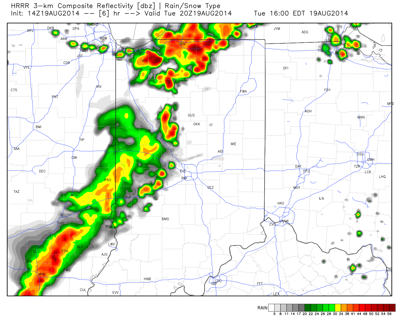
A look at some of the latest data hot off the press suggests we remain under fire for the potential of scattered strong to severe thunderstorms late afternoon into the evening hours. Initial activity could fire as early as 3-4 o’clock across western sections. The latest HRRR forecast radar (valid at 4pm) shows an advancing line of strong, and possibly severe, storms pushing east.

Again, the primary threat is damaging wind, but a couple hail reports will also be possible.
As of the 12 o’clock hour, a complex of thunderstorms sits to our west across western/ central portions of Illinois. We’ll keep a close eye on this complex as it continues pushing east and likely intensifies in a hot, humid, and unstable air mass over the next few hours. Please plan a way to keep abreast of the latest radar and local media this afternoon and evening as storms move in.
Permanent link to this article: https://indywx.com/2014/08/19/still-focused-on-this-evening-for-severe-storm-potential/
-
Filed under Canadian Model, Forecast, Forecast Discussion, Forecast Models, GFS, Heavy Rain, NAEFS, NAM Model, Rain, Severe Weather, Summer, T-storms, Unseasonably Cool Weather, Unseasonably Warm, Weather Videos
-
August 18, 2014
Tonight’s video update highlights:
- Tuesday severe threat
- Big-time weekend heat
- Cooler pattern to wrap up August

The Storm Prediction Center has outlined a risk of severe weather Tuesday across the state.
Permanent link to this article: https://indywx.com/2014/08/18/severe-weather-threat-tuesday/
-
Filed under 7-Day Outlook, Forecast, Forecast Discussion, Forecast Models, Heavy Rain, NAM Model, Rain, Summer, T-storms, Unseasonably Cool Weather
-
August 14, 2014
|
Thr.
|
Fri.
|
Sat.
|
Sun.
|
Mon.
|
Tue.
|
Wed.
|
|

|

|

|

|

|

|

|
|
55/ 78
|
48/ 76
|
56/ 81
|
64/ 83
|
69/ 81
|
70/ 81
|
67/ 85
|
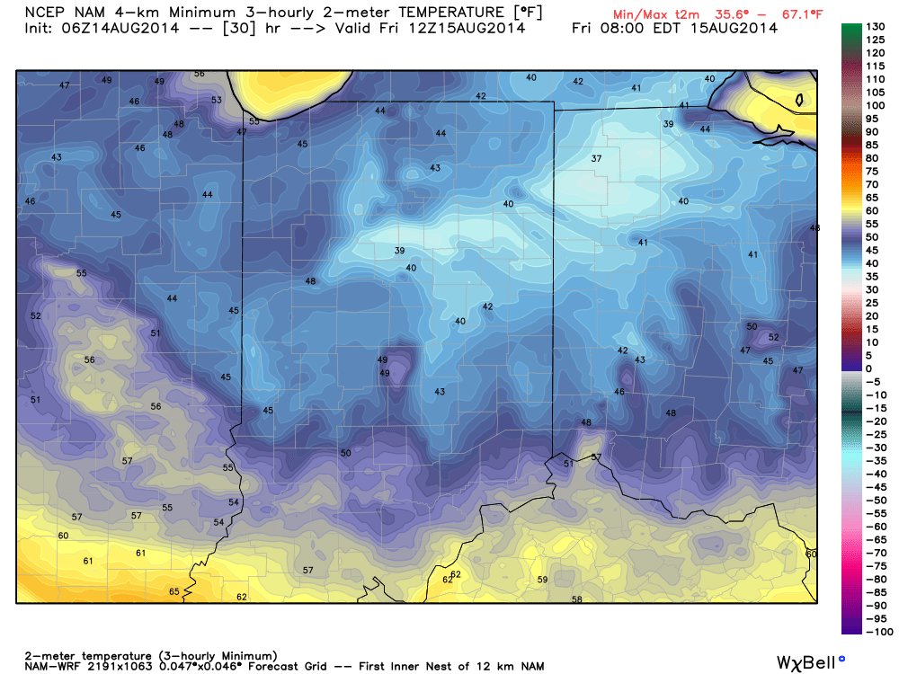
Reinforcing Cool Air Blowing In…A reinforcing push of cool air is blowing into town today and will result in a downright chilly night ahead (especially considering the time of year). A couple showers can still be expected across south-central parts of the state, but won’t amount to much. The big news will be the chilly temperatures tonight as we forecast upper 40s officially in the city and low to mid 40s across northeastern suburbs. Highs will only climb into the middle 70s with lots of sunshine Friday.
Warmer And More Unsettled…Temperatures will moderate into the weekend, but we’re also going to introduce rain chances back into the picture. Most of Saturday will remain rain-free, but we can’t rule out scattered showers and thunderstorms as the first in a series of disturbances tries to overcome initial dry air in place. Better rain and storm chances will prevail Sunday.
Heavy Rain Next Week…Forecast rainfall numbers continue to rise next week as a series of weather makers impacts central Indiana. A good consensus would place 1.5″ to 2″ of rain down, with locally heavier totals. Stay tuned as we fine tune timing.
7-Day Precipitation Outlook:
- 7-Day Rainfall Forecast: 1.5″-2″
- 7-Day Snowfall Forecast: 0.00″
We’re enjoying another colorful sunrise across central Indiana this morning. John Salewicz snapped this scenic photo earlier this morning. Thanks, John!


Throw an extra blanket on the bed tonight! Temperatures will dip into the mid to upper 40s for many.
Permanent link to this article: https://indywx.com/2014/08/14/throw-an-extra-blanket-on-the-bed-tonight/


