Widespread Rain This Morning Then Watching For Strong-Severe Storms This Evening…

Happy Saturday all!  Widespread rain and embedded thunder will overspread central IN as we progress through the morning hours.  Steady rain will continue through the lunchtime hour before we see a break in widespread rains.
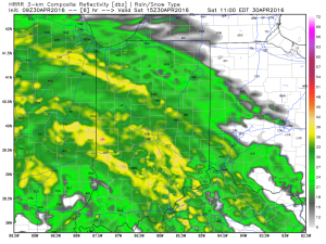
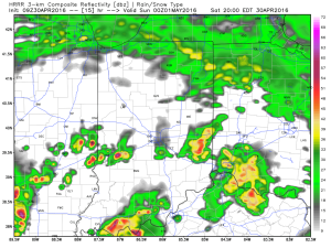
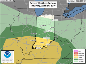
1After a break in the rain, we’ll have to keep an eye on the potential of strong to severe storms developing this afternoon and evening (especially across southern IN).  Hail and damaging winds are of greatest concern with storms that develop, but a tornado is also possible.
2

IN_swody1Another round of scattered thunderstorms will rumble across the state Sunday.
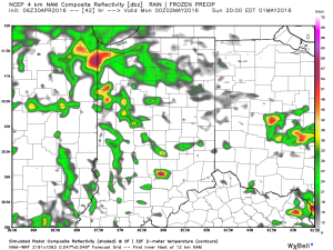
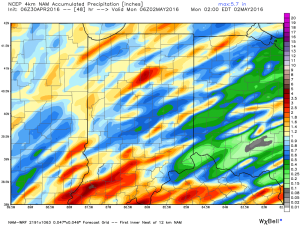
3Widespread weekend rainfall totals should fall in the 1″-1.5″ range for most, but there will also be some locally heavier totals.
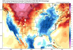
4As we progress into the upcoming week, cool air will be the big weather story.  Perhaps the coolest days will be next Thursday-Friday (lows in the 30s and highs in the 50s).
5

Thursday Morning Weather Notebook…

Noisy thunderstorms (non-severe) are impacting southern ‘burbs this morning, but dry time is coming as we get into the heart of the rush hour.  This dry time will continue into the late morning hours, but renewed showers and thunder will likely fire yet again early this afternoon (in scattered fashion).

2After an unsettled few days, we’ll get a break, albeit brief, from the wet, stormy times to close the work week.  High pressure will present an increasingly sunny sky Friday, but it’ll be much cooler than today (mid 60s for highs Friday).

4As mentioned, dry times won’t last long.  Rain builds back in Saturday and lingers into Sunday.  Locally heavy rain is possible, including embedded thunderstorms.  Early rain numbers fall in the 1″-1.5″ range over the weekend.

3As we open May, attention turns to a much cooler than normal feel of things.  In fact, overnight data is particularly bullish on the chill next Thursday morning (suggests mid 30s).

1

Another Round Of Storms This Afternoon…

Heaviest concentration of storms Tuesday was along the I-70 corridor and points south.  We think today coverage of rain and thunderstorms will be more widespread across the state…

We’re off to a cool and quiet start this morning, but think things will turn rather busy yet again as early as the early-mid afternoon hours.  Unsettled conditions will continue through the night.

Latest scans of the HRRR future-cast radar product suggests we need to monitor for high wind potential during the early to mid afternoon hours.  We’ll keep a close eye on this.

1

2The high resolution NAM future-cast radar is slower, but also shows strong to possibly severe storms into central IN late tonight.

3The current SPC outlook highlights far southwestern IN for the chance of severe weather today. Don’t be surprised if this is expanded northeast with later updates today.

4Rainfall potential today-tonight should feature many neighborhoods accumulating an additional inch, with some locally heavier totals.

Active Times, My Friend…

We enjoyed a brilliant Saturday across central Indiana. Plentiful sunshine developed, as expected, after a cloudy, drizzly start in areas. Temperatures topped out in the mid to upper 60s for…

You must be logged in to view this content. Click Here to become a member of IndyWX.com for full access.  Already a member of IndyWx.com All-Access?  Log-in here.

Saturday Morning Rambles…

April is running nearly 6° below average and nearly spot-on where we should be from a precipitation perspective through the 15th.       As we move forward, the big story…

You must be logged in to view this content. Click Here to become a member of IndyWX.com for full access.  Already a member of IndyWx.com All-Access?  Log-in here.