
You must be logged in to view this content. Click Here to become a member of IndyWX.com for full access. Already a member of IndyWx.com All-Access? Log-in here.
Category: Forecast Discussion
Permanent link to this article: https://indywx.com/video-weekend-heavy-rain-threat/
Aug 08
Monitoring Prospects For Heavy Weekend Rain…
A combination of ingredients are coming together to offer up the potential of heavy rain for portions of the region this weekend.
An approaching cold front will drop slowly southeast out of the Plains while a tropical low moves inland from the central Gulf Coast.
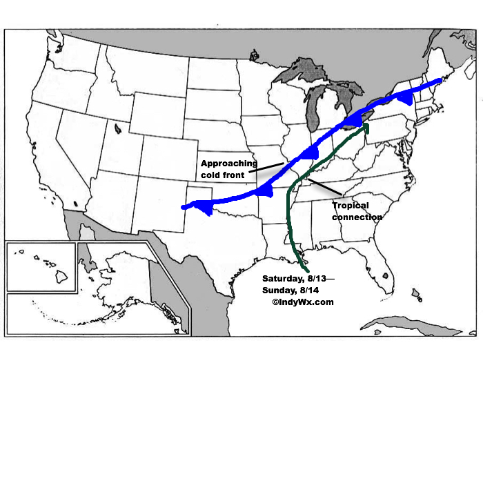 The precise placement of the front will serve as the focal point for heavy weekend rains. As we’d expect from this distance, modeling disagrees on the all-important specifics. Using a model blend, central Indiana is on the table for heavy late week-weekend rain as of now. Precipitable water values (PWATs) will be above 2″ and suggest the threat of torrential downpours, including localized flash flooding across the Ohio Valley. Eventually, the cold front will sweep the tropical-rich moisture away from the region and cooler, much less humid air will press in by this time next week.
We still have time to watch the evolution of things play out as we progress through mid week. Stay tuned as we “sure-up” the details and hone in on the area where heavy rain is likely.
Permanent link to this article: https://indywx.com/monitoring-prospects-for-heavy-weekend-rain/
Aug 04
Storms For Some; More Winter Chatter…
You must be logged in to view this content. Click Here to become a member of IndyWX.com for full access. Already a member of IndyWx.com All-Access? Log-in here.
Permanent link to this article: https://indywx.com/storms-for-some-more-winter-chatter/
Jul 31
More Active Pattern Early Week…
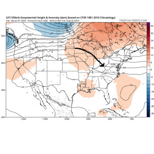
The Corn Belt and parts of the Ohio Valley will be in a favorable position for periods of storminess as we progress through the early portions of the new week.
It’s an admittedly tricky pattern when it comes down to the all-important details (timing, track, etc.), but just know from this distance, it’s a pattern conducive for thunderstorm development and localized flash flooding.

The region will be located on the NE flank of a hot dome centered to our SW.
Disturbances love to ride northwest to southeast around the periphery of the ridge. Accordingly, the subtle northwest flow aloft will likely send a couple disturbances into the region over the early week stretch.
 The atmosphere will be loaded with moisture and precipitable water values (2″+) will promote localized flash flooding within the storm complexes.
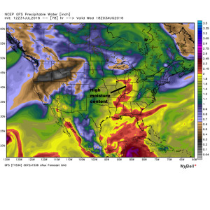 We think the initial wave of storms will ride southeast late tonight and early Monday and could encompass SW portions of the forecast area. The pattern is favorable for additional storm complexes to travel southeast Tuesday and Wednesday, however.
With the moisture content in the atmosphere, localized flash flooding will result where training takes place. We caution that this won’t be a uniform event (some neighborhoods will see a half inch of rain this week while others may see as much as 3″-4″). We’ll have to treat each complex as they come and fine tune the specifics within the forecast.
Permanent link to this article: https://indywx.com/more-active-pattern-early-week/
Jul 30
The Last Month Of Meteorological Summer Is Upon Us…
You must be logged in to view this content. Click Here to become a member of IndyWX.com for full access. Already a member of IndyWx.com All-Access? Log-in here.
Permanent link to this article: https://indywx.com/the-last-month-of-meteorological-summer-is-upon-us/