Through (5) weeks of meteorological winter, it’s been a frustrating time for snow and cold weather enthusiasts across the beautiful state of Indiana. We’ve seen a few storms cut into the central Lakes, taking their respected snow swaths northwest of central Indiana. Despite an “overachieving” arctic wave on the 13th and an icy glaze event the following Friday night, it’s been a rather uneventful winter so far. In ironic fashion, a significant winter event is poised to impact portions of the Lower 48 this weekend, but the general consensus in modeling is for this event not to cut northwest, but, instead, remain suppressed and impact portions of the TN Valley and Southern Appalachians with heavy snow. Now, sure, there’s still time for this to “correct” north, but as of this writing, there’s just as much argument in the suppressed idea.
Admittedly, we, personally, believed we would be much farther along in the snowfall department than we are through the first 1/3 of meteorological winter. Looking ahead, there really isn’t much to “like” about the longer term data as far as getting snow prospects. Sure, an arctic shot is still inbound come mid week with very cold air. We note AK ridging and blocking “trying” to develop over Greenland.
 This will take us through mid week and into the weekend with lows in the single digits and lower teens and highs generally in the lower and middle 20s. We still need to watch Thursday evening-night for a wave of low pressure that may attempt to deliver light snow, but this doesn’t look like a significant event from this distance.
Additionally, we’ll keep a close eye on the weekend for the prospects of snow, but confidence remains very low in regards to this system. The GFS ensemble members show the wide range of possibilities Saturday. Taken verbatim, the respected (or not ;-)) solutions, range from “no snow for you” scenarios to a big hit.
 To further complicate matters, the European and Canadian solutions are much less robust and result in a more suppressed scenario. Forecasters (including yours truly) can only wish for the days to return of worrying about respected snow/ mix/ rain lines amongst the various data, versus the present time of models showing a storm only to take it away from run-to-run and other modeling not even showing the storm.
But once to mid-month, the overall pattern is forecast to break down yet again and results in a much warmer look for the east.
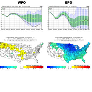
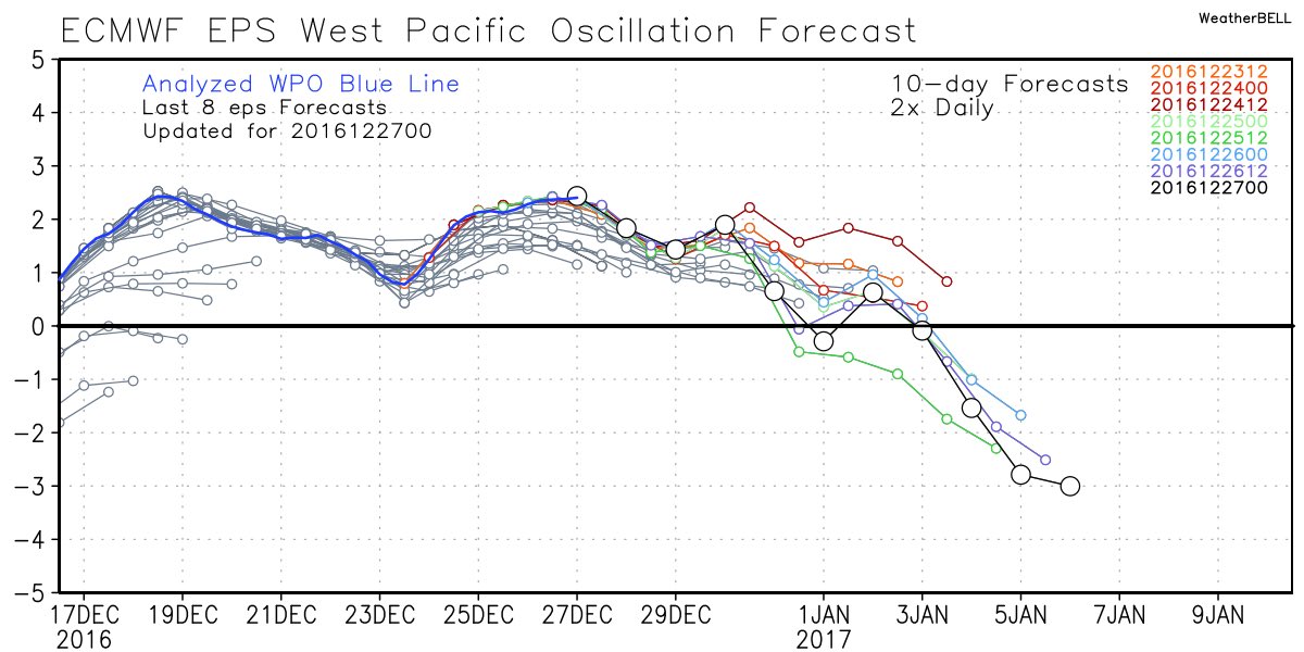
 That brings us to our next point and that’s the modeling performance, itself. For really the better part of a year now, modeling has been poor, at best- even in the short-term solutions. More recently speaking to the last few months, I can’t recall model data ever performing worse (13 years of forecasting experience). It leads to a very low confidence forecast in basically anything beyond (7) days right now. Additionally, conflicting signals are present (as posted this morning, the AO, EPO, WPO favor cold versus the MJO strongly favoring warmth in the longer range). The signals are competing with themselves to try and take over the overall weather pattern for mid and late winter, but I’m not sure we’re really ever going to get to a point where we “lock-in” to any one particular warm or cold pattern for any sustained length of time this winter. As far as snow goes, there’s no way in early January you’ll ever see us greatly alter the long-standing ideas posted originally in the winter outlook. When a given city averages 26″ of snow on the winter, it only takes one storm to come along and put you in a “good spot” (relative to average). That said, we hear your frustrations (and know they will only grow louder this weekend if our friends down south cash in on the snowy goods). Once to late January, we’ll revisit this idea.
The one thing we try to do here is eliminate the “noise” in the short, mid, and long range data by analyzing it all and building a forecast using a blend of the said data, along with teleconnections, etc. You’ll never see us update our forecast based on a model run every time in comes in. We don’t buy into the idea of “knee jerk” forecasting. Let’s sit back and watch the next few days unfold. Unfortunately, in this weather pattern, we just don’t see confidence increasing in forecasts much past the 3-7 day window at this juncture.
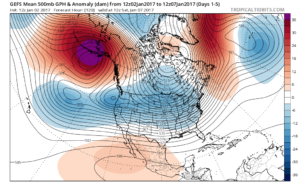
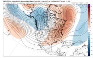
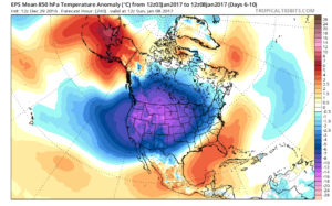
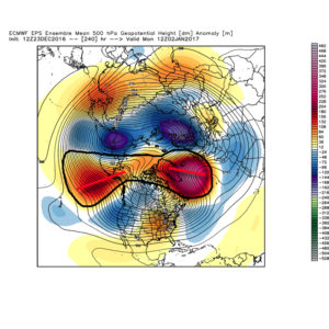
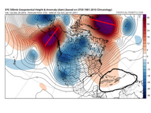 By Day (10), the cold pattern is well established over the Lower 48. This is a coast-to-coast cold signal (heart of the cold centered over the west and central) depicted by the European ensemble, along with other modeling.
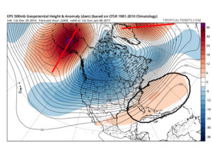
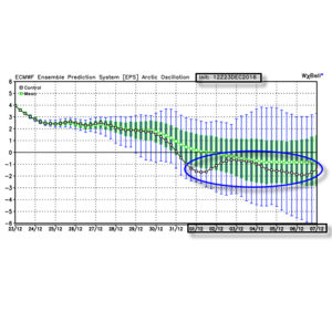
 Teleconnections support a cold pattern returning.
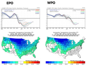
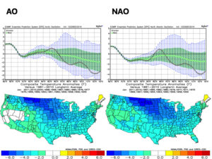
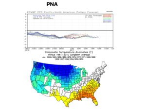 The agreement amongst teleconnections is nice to see and ups confidence in the overall direction of where this pattern is heading in regards to colder than average times looming. The negative PNA correlates nicely with the SE ridge that continues to make itself heard from time to time over the next few weeks. It should also be noted that the phases of the Arctic Oscillation (AO) and North Atlantic Oscillation (NAO) become more of a factor for mid and late winter.
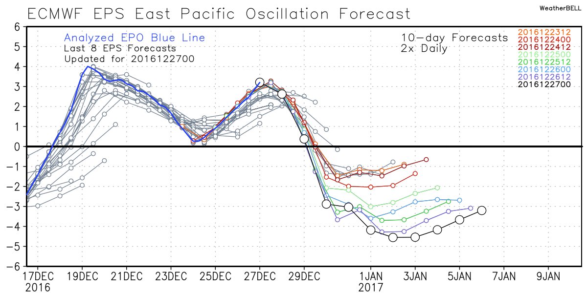
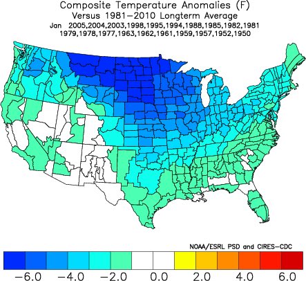
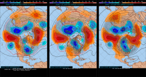
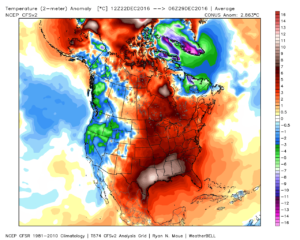
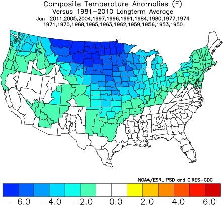 Accordingly, we see the ensemble data flipping to a colder pattern over the upcoming (10) days. Note the low anomalies in the higher latitude regions today (Image 1) versus Day 10 (Image 2).
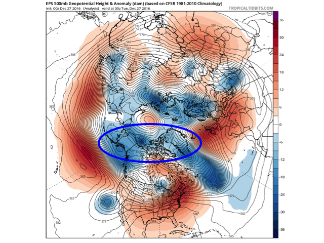
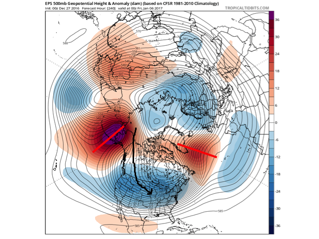 The pattern developing by Day (10) is one capable of producing another frigid regime- only January style. Cross-polar flow sets up shop and, unlike, December, some blocking is noted, as well. This can help the mean storm track shift further south. (Bye-bye Great Lakes cutters, though Mid Western and Ohio Valley Snow Lovers will find a new worry in the form of suppression potential ;-)). Individual storms will have their respected challenges, as always. As a whole, it’s a very cold, stormy look and a pattern capable of leading to an expanding snow pack across the Lower 48.
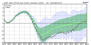
 We note ensemble data is suggesting high latitude blocking tries to develop towards Day 10. Recall this was the missing ingredient in the bitterly cold blasts of air that occurred during the first few weeks of December. Both the GEFS and EPS agree on the increasingly blocky look to the pattern by Day 10. This would help drive a cold, stormy pattern by early January. Instead of storms cutting, we would see more suppression. With a “stubborn” southeast ridge, things could get interesting across the Ohio Valley from a wintry perspective….
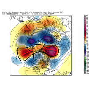
 We don’t want to jump the gun, but it the positives can “hook up” over the pole, we stand the chance of locking into a rather lengthy cold, snowy regime as we rumble deeper into the heart of winter.
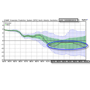
 Summary: A rather mild regime remains as we rumble through Christmas before trending more seasonable next week. From a wintry perspective we need to continue to keep an eye on the period around New Year’s Eve/ Day. Confidence continues to increase on the potential of a return of arctic air come early January.
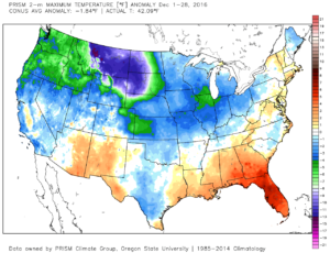
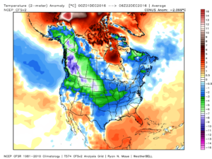 This is, of course, is in stark contrast to December 2015.
 As we move forward, an active pattern awaits between now and the end of the year. This comes after a few days to catch our breath, including moderating temperatures leading up to Christmas.
 Christmas Eve will feature overcast skies with areas of fog and drizzle, but the majority of the concentrated rain should fall south of the region. Santa’s ride into central IN should be uneventful, weather-wise.
 Temperatures will fall through the day Monday and we should run much closer to seasonable temperatures next week. A couple of additional storm systems will have to be monitored for rain and snow prospects the middle of next week and again around New Year’s Eve/ Day. Initially, we’ll be rather mild, but there may be more in the way of cold air readily available to make the storm system around New Years “more interesting” from a wintry perspective.