
You must be logged in to view this content. Click Here to become a member of IndyWX.com for full access. Already a member of IndyWx.com All-Access? Log-in here.
Category: Forecast Discussion
Permanent link to this article: https://indywx.com/weekend-video-update/
Jan 18
Times Are Changing, Or Are They?
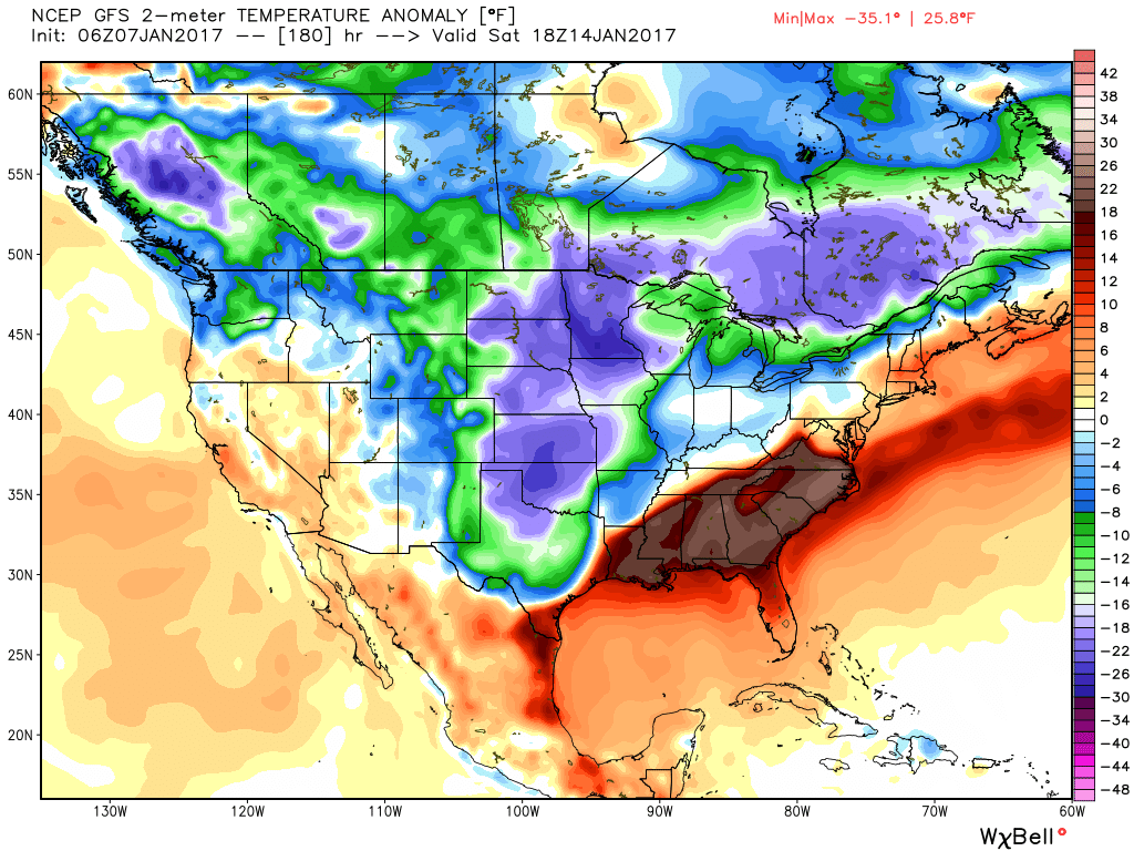
January-to-date is running milder than normal across the region- to the tune of 3.3 degrees (F). This is after a frigid open to the month, as you recall.
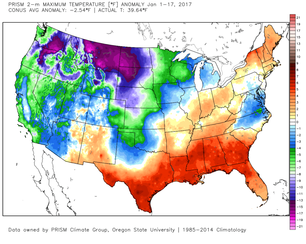 The second week of the month warmed significantly and continues, overall, for the next week.
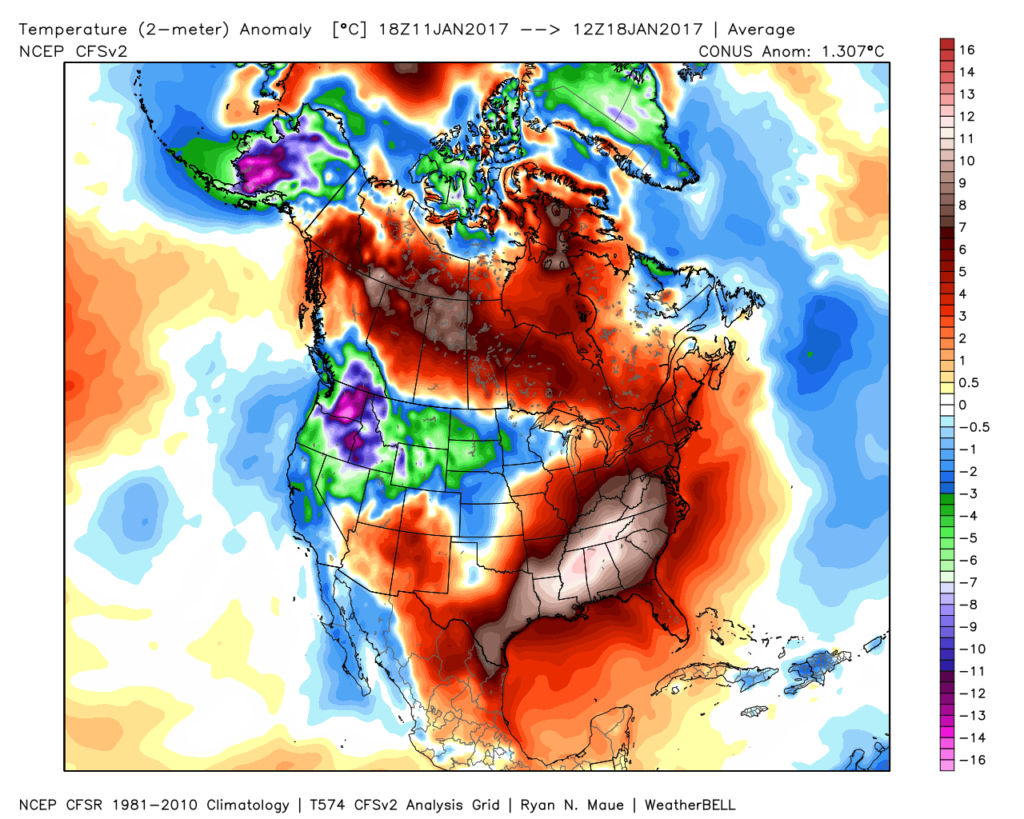 The mid-January warmth is attributed to a roaring PAC jet which is currently helping flood the country with temperatures much more like spring than the dead of winter. We continue to forecast 60+ this weekend across central IN.
Winter lovers, have no fear as changes appear to be in the offing as we go through the last few days of January and head into February. The winter so far has featured conflicting signals that continue to try and compete with one another to take hold of the pattern. Can we get these drivers to align in a way that would pull a more persistent trough into the east for the second half of the winter and, ultimately, set-up a sustained cold pattern helping make up for lost time in the snowfall department? Time will tell, but we do note the following late month:
- (+) PNA pattern
- Sudden stratospheric warming event
- High latitude blocking
All are encouraging for a shift back towards a wintry regime. As always, the devil is in the details and we’re skeptical as to the longevity of these signals. “Cautiously optimistic” would be the way to sum up our current feel longer-term into the month of February, but we’re not as bullish on lock and hold cold, wintry conditions at this time as what you may hear from some of our national compadres. Understanding that various drivers can have a different impact mid and late winter as opposed to early is one thing. It’s also important to note that long term modeling has been abysmal as of late and we want to tread through the next couple of weeks with caution to see whether or not the cold drivers can finally take hold.
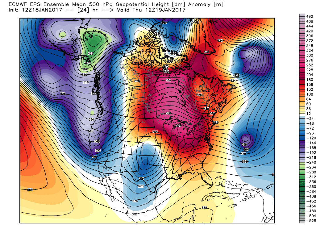
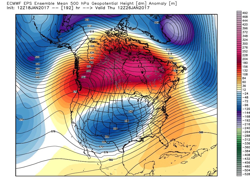
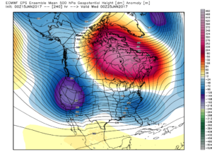
Needless to say, at least through late month, one can see the significant changes take place at 500mb.
Thursday:
 This Weekend:
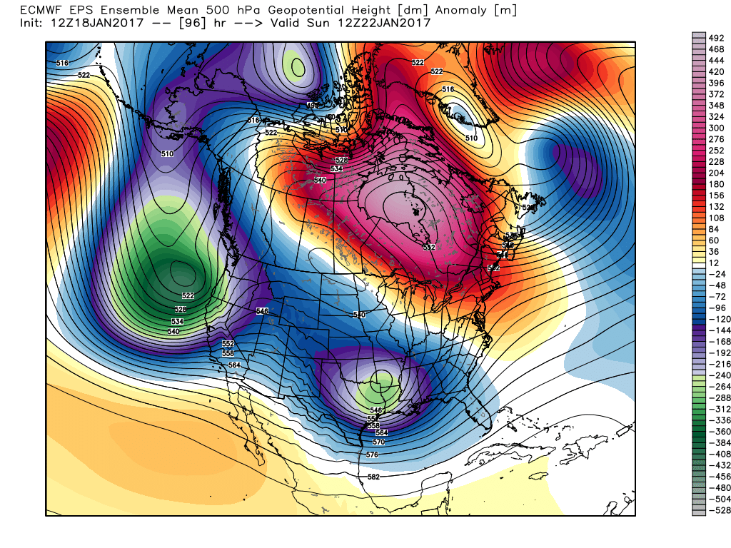 Next Thursday:
 Next Weekend:
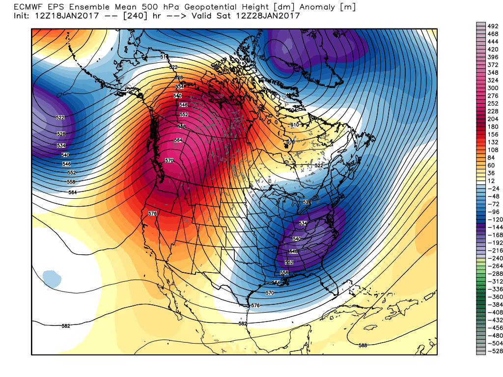 The pattern begins in the short-term with a look that will power anomalous warmth through the weekend, along with renewed rain chances Thursday night into Friday (another 1″+ for most), but begins to shift next week towards the colder look. The 2nd (weekend) storm system will be significant and poses a severe risk to the southeast region. Modeling has backed away on the heavy rain threat Sunday, but showers will be around early next week along with very windy conditions (40+ MPH gusts). Blocking is forcing the low south. By the time we get to next weekend, the pattern has done a 180 and in a position to drill unseasonably cold air back into the central and eastern portions of the country.
As far as storms go later in the period, it’s far too early to discuss specifics, but the pattern seems to be one that will promote the chance to get into the act on high-ratio producing clippers. It’s the first time we can say that this year. Time will tell…
Permanent link to this article: https://indywx.com/times-are-changing-or-are-they/
Jan 15
Sunday Afternoon Rambles…
1.) January, month-to-date, is running slightly above normal at IND (+1.2 F) and nearly 1″ above normal in the precipitation department. Keeping true to the winter, overall, greatest cold departures are centered over the northern Plains and northern Rockies.
 2.) Showers will creep north overnight into Monday morning, but shouldn’t amount to much. They will be scattered in nature across central Indiana.
 3.) More widespread rain and embedded thunder will develop Monday night into Tuesday morning. This should amount of widespread half inch to one inch totals across the viewing area.
 4.) A moist southwest flow will help push a warmer regime northward for the second half of the week. Though warm, we’ll also have to deal with periods of rain as disturbances track northeast. We circle Friday and Sunday as the wettest days and remain optimistic Saturday will feature dry and unseasonably warm conditions (lower-middle 60s). Between the rainy days Friday and Sunday, additional rainfall totals of 1″-2″ seem like a good bet.
 5.) The evolution of the pattern just beyond the 7-day period we’ll begin to take on an increasingly wintry look and we remain confident on a flip back to wintry conditions as we roll through the last week of the month. We’ll have to keep a close eye on a storm system in the 8-10 day period. It’s obviously way too early to discuss specifics, but this will be the time the pattern is beginning to turn back towards a wintry regime…
Permanent link to this article: https://indywx.com/sunday-afternoon-rambles-2/
Jan 11
Icy Set-Up This Weekend…
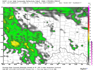
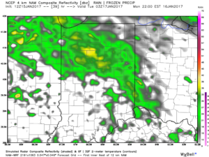
Unfortunately, a strong arctic high still looks like it’ll descend into the upper Mid West Friday before moving east over the Great Lakes (Saturday) and into the northeast (Sunday). This will help shove a cold front south to the upper TN Valley Friday and dense, cold air will bleed south to encompass central Indiana as we wrap up the work week. As we progress into the weekend, warm moist air will override the shallow cold air locked in place at the surface. Ripples of energy will move along the boundary and periods of more concentrated, steadier precipitation will fall. Significant ice accumulations (greater than one quarter inch) will be possible for portions of central Indiana.
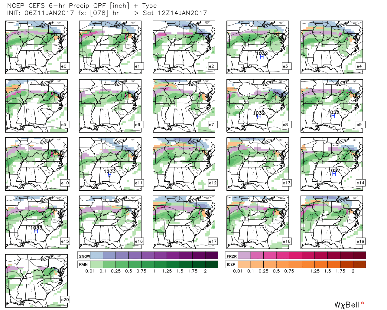 GFS ensemble members above show the overall good agreement on a central IN ice set-up for portions of the weekend.
Timing: As of now, I think most of Friday is dry and cold before moisture overspreads the region late Friday night into Saturday. Additional waves of moisture will push through the region during the second half of the weekend, as well.
Confidence: We have very high confidence on at least light to moderate icing in the Friday night – Saturday time frame, but confidence on additional icing thereafter begins to drop, thanks to disagreement in modeling. The GFS is warmer for the second half of the weekend and would reduce the threat of significant ice build-up as some brief thawing would be in place in between waves of moisture thanks to temperatures rising into the middle 30s. However, the European model is much colder and keeps IND below freezing Saturday and Sunday, with nearly half an inch of liquid during that time frame. That’s downright concerning and would result in significant issues with potentially downed tree limbs and power lines.
We do have concern the European could have a better handle on things right now. Modeling is notorious for underestimating the strength and depth of the cold air with these arctic highs and similar overrunning events of the past. Stay tuned.
Impacts: Greatest concern right now is for icing on exposed and elevated surfaces (bridges, tree limbs, power lines, etc.). With the milder air of midweek, along with marginally cold air, it’s possible crews will be able to keep roads passable during this event. Additionally, something else to consider is the rate of precipitation. While bad for elevated ice build-up, if precipitation rates are heavy enough, this can help reduce ice build-up on roadways.
Summary: We still have concern for the potential of an impactful ice event this weekend through central Indiana. Winter Storm Watches (and potentially Ice Storm Warnings) may be hoisted by the National Weather Service later this week for this event. Despite an overall high confidence in at least some icing impacting the region, questions do remain in regards to the temperature profile later in the forecast period this weekend, and caution the slighted deviation in surface temperature can make all the difference to impacts. At the very least, low pressure should pull out of the southern Plains early next week and this will serve to push enough warm air northeast to change everything over to plain ole rain early next week as we rise into the 50s.
Permanent link to this article: https://indywx.com/icy-set-up-this-weekend/
Jan 07
Saturday Morning Rambles…
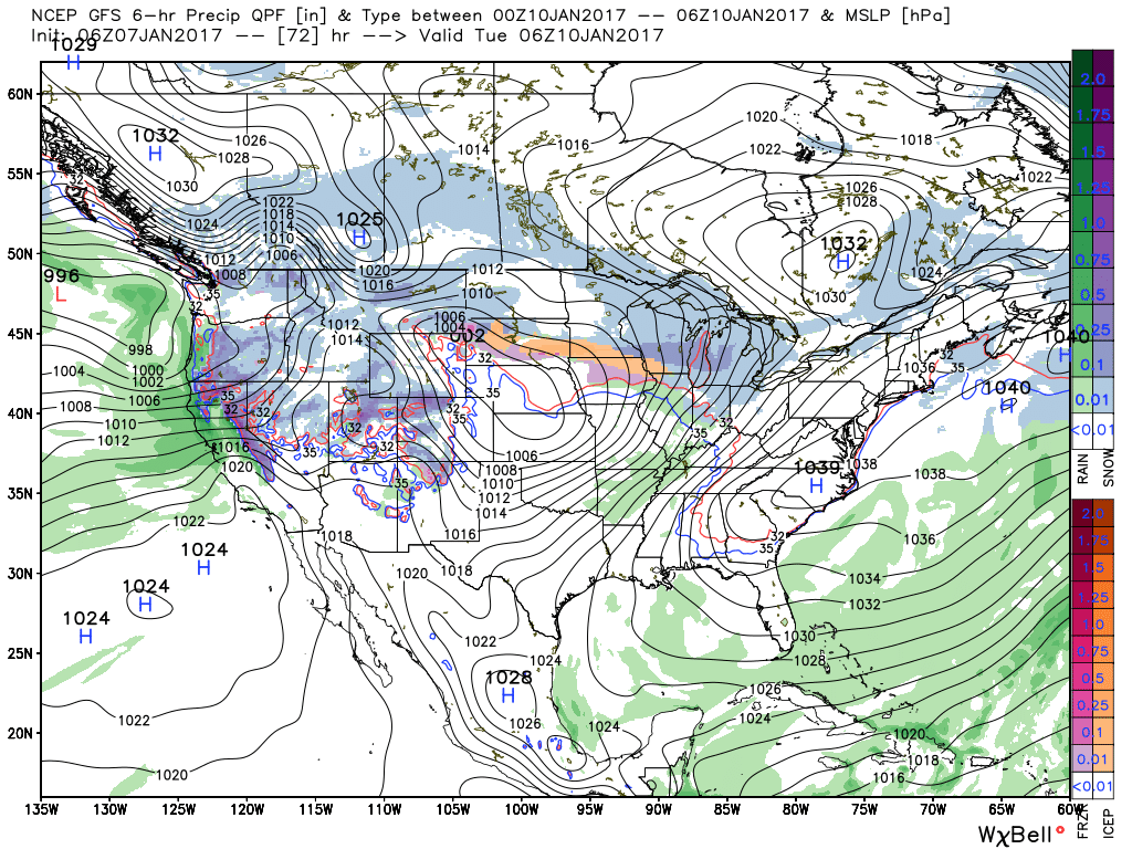
1.) Coast-to-coast cold: The Lower 48 is waking up in an ice box this morning as widespread arctic air and below normal temperatures engulf the country (minus the FL peninsula this morning). The arctic express will remain with us through the weekend, including temperatures once again tonight that threaten to dip into the sub-zero range across central Indiana. Highs today will only reach the middle 10s and upper 10s to lower 20s Sunday. Bundle up and stay warm.
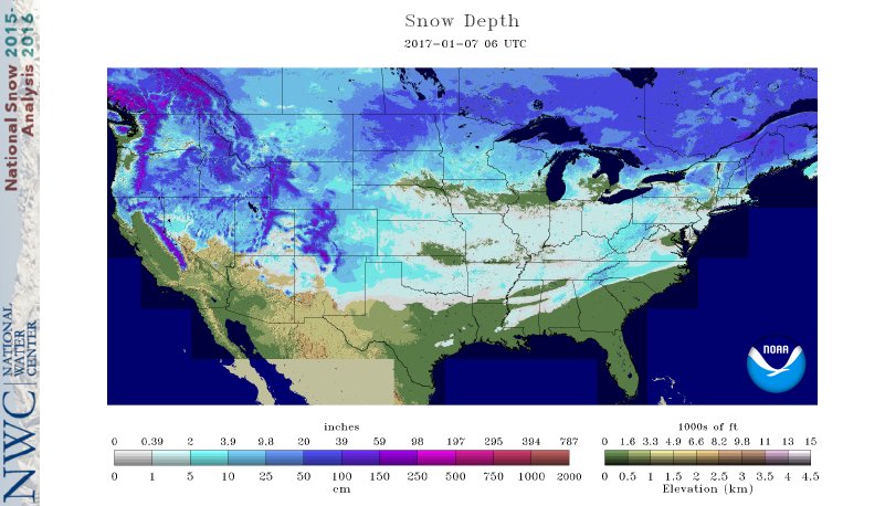
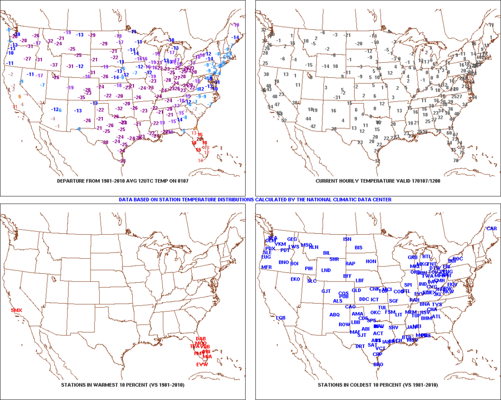 2.) Expanding Snowpack: 65.4% of the country is covered in snow this morning. The cold, arctic high suppressed the winter storm threat south as we alluded to in previous posts. Places across the Deep South that aren’t used to wintry precipitation are waking up to snowy and icy conditions this morning, including MS, AL, GA, SC, and into the Mid Atlantic. Heavier snowfall accumulated across east TN, including 5″-8″ in the high country. Heavy snow also fell through western and central NC and Blizzard Warnings are up in rare areas including VA Beach this morning.
 3.) Moderating Temperatures: Our air flow will back around to the southwest and this will help temperatures begin to moderate early next week (around freezing Monday and all the way to around 50 Tuesday). As the moderating trend gets underway, we may have to deal with a brief period of freezing drizzle/ freezing rain Monday evening.
 4.) Rainy Midweek: A more significant surge of moisture will arrive midweek and result in periods of moderate to heavy rain Wednesday PM into Thursday. Potential is present for 1″+ during this timeframe.
 5.) Weekend Wintry “Fun And Games?” A tremendous battle will take place next weekend between a strong and sprawling arctic high pressure system and the southeast ridge. In between it’ll be fascinating to watch things unfold, and as you’d imagine, that includes Indiana. Despite the southeast ridge flexing it’s muscle, the concern here is that the shallow dense arctic air will “ooze” south and present an icy set-up for portions of the Ohio Valley and Mid West for the weekend. We still have some time to watch this, but the potential of significant icing is very much present for some and this will require a close eye through the week.
Permanent link to this article: https://indywx.com/saturday-morning-rambles-9/