
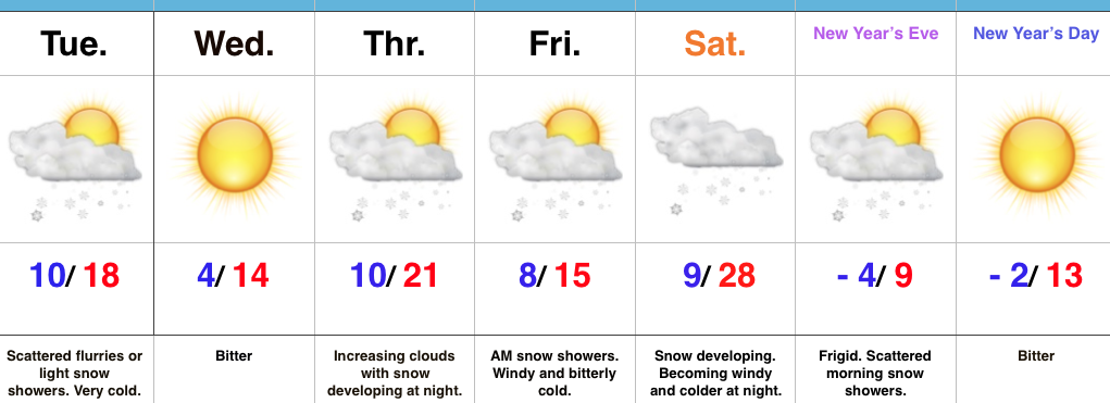
 Highlights:
- Light snow chances
- Frigid times
- Bitter close to 2017
Heavy Winter Gear Required…First and foremost, we want to wish each and every one of you a very Merry Christmas and a continued blessed and safe holiday season.
The upcoming forecast period will be dominated by bitterly cold conditions. At times, jabs of dangerous cold will penetrate into the Ohio Valley. With arctic high pressure attempting to dominate the pattern, it’ll “out muscle” the potential of any sort of major widespread winter storm threats. With that said, it won’t eliminate snow chances altogether and we must remain on our toes for the chances of a more impactful event over the weekend.
Beforehand, light scattered snow showers are possible late tonight into Tuesday morning as arctic reinforcements blow into town. Two additional opportunities for snow will present themselves Thursday night into Friday morning, and, as mentioned above, just before the New Year.
Keep the heavy winter gear handy through the forecast period as Old Man Winter make his presence felt.
Upcoming 7-Day Precipitation Forecast:
- Snowfall: 1″ to 3″
- Rainfall: 0.00″
 Snow will begin to overspread the state, especially north of the I-70 corridor during the mid-to-late morning hours and we expect a steady snow to fall across the northern half of the state throughout the majority of the day. A period of moderate to heavy snow should develop during the mid-to-late afternoon, continuing into the evening hours across central Indiana. Road conditions will begin to really deteriorate during this time frame as surface temperatures fall into the 20s.
 Eventually, snow will end from west (around 8p) to east (around midnight) tomorrow night, but not before depositing a widespread swath of 3″-5″ for areas generally north of I-70. For the city, itself, we think 2″ to 3″ is a good call, with generally an inch, or less across far southern portions of the state.
 Don’t be surprised if enough Christmas “magic” results in localized heavier totals with potential banding that develops tomorrow afternoon into the evening hours. All in all, this will be a classic, picturesque snow event for Christmas Eve. Hoosiers will wake up Christmas morning with a fresh blanket of white.
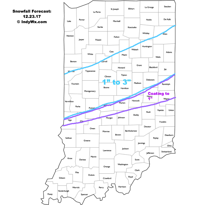 A more widespread, “uniform” (easier to forecast, as well :-)) snow event will arrive Christmas Eve. Upper level energy will cross the Ohio Valley and combine with arctic air in place to maximize moisture production. We expect an expanding area of snow to encompass most of the state Christmas Eve, likely becoming most widespread Christmas Eve afternoon. With cold air in place, roads will likely get slick in spots so plan accordingly with your travels.
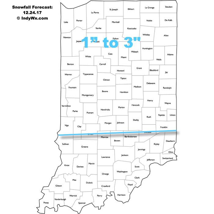 The hits keep coming as we progress into next week. An additional accumulating snow event may arrive Christmas night into Tuesday, followed by a more widespread and potentially major event late next week…