
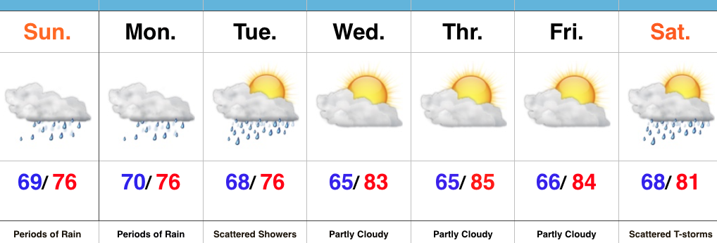
 Highlights:
- Periods of heavy rain
- Drying out come mid week
- Cold front arrives next weekend
Flooding Concerns…Renewed heavy rain is pushing through central IN as we write up the morning forecast package. This conveyor belt of moisture will continue to lift northeast and eventually break up and diminish during the late morning and early afternoon. Despite scattered showers this afternoon, drier times will ensue, overall. Unfortunately, this drier period won’t last long as another slug of moisture lifts north late tonight and continues Monday. Additional heavy rainfall can be expected, including the potential of rainfall rates approaching 2″+/ hour. Given the water-logged soils across the region, concerns of flash flooding are very high Monday.
Eventually, we’ll dry things out come mid week and introduce more sunshine back into the forecast. Our next item on the agenda will be a cold front that will sweep through the state Saturday. Scattered showers and thunderstorms will accompany the boundary as it moves through the region before much drier and cooler air blows in for the second half of the weekend. In fact, a welcomed early fall preview awaits come Sunday. Thoughts of football, pumpkin “everything,” bonfires, and apple cider will be prevalent this time next week…
Upcoming 7-Day Precipitation Forecast:
- Snowfall: 0.00″
- Rainfall: 2″-4″ (locally heavier totals)


 Unlike the localized banding features of the rain today, the rain shield should be much more widespread Monday into Tuesday. Factor in the hefty rain totals today into Sunday, combined with additional heavy rain Monday and Tuesday, and it wouldn’t surprise us to see a few double digit rainfall reports by the time all is said and done Wednesday night/ Thursday. Widespread 4″+ totals will be common across central IN by the time all is said and done.
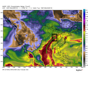
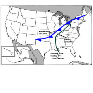 Despite lackluster model output from our American suite (latest NAM and SREF data, for instance, paints rainfall totals under 1″ across most central IN neighborhoods), the European remains consistent on the evolution of things from this weekend into the middle of next week. We’ll lean more towards it’s solution at this juncture. Simply put, when you have a stalled frontal boundary entraining tropical moisture, expect problems. Precipitable water values will approach and even exceed 2″ at times this weekend. Dew points will remain in the upper 60s to lower 70s along and south of the boundary. Where the boundary stalls will be key in determining the heaviest rain totals and resulting flood problems that will ensue. For now, here’s the best idea we have in regards to local 4″+ totals between this weekend and next Wednesday.
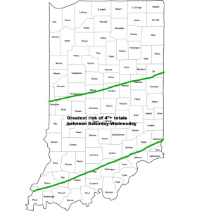 It should also be pointed out that we’re not looking at all day rains Saturday through Wednesday, but instead “waves” of moisture throughout the period. Areas of locally heavy rain will be with us, but we’ll also see dry periods in between. Thankfully, as we move into the latter portions of next week, drier times should return.