Enjoy our relatively quiet and briefly milder weather pattern as mid and long range guidance suggests we reload the cold with authority and associated wintry precipitation threats…
You must be logged in to view this content. Click Here to become a member of IndyWX.com for full access. Already a member of IndyWx.com All-Access? Log-in here.
January is off to a colder than average start across a large portion of the country, including the Hoosier state:
The snow and ice pack has expanded over the past couple of weeks in rather significant fashion:
Two storm systems have offered up busy times over the Ohio Valley the past week. Note liquid equivalent numbers the past (7) days- most significant over central Indiana. Most of this has been in the form of wintry precipitation (snow and ice).
A weak weather system may offer up light snow chances mid week. The high resolution NAM and European print off light snow while other models “see” us mainly dry mid week.
The other big story in the short term will be more bitterly cold arctic air (single digits tonight and close to zero Wednesday morning).
While we’ll certainly “warm” compared to the freezer we’ve been in the first two weeks of January, sneaky arctic highs remain on the field and will put a dent in the air masses from reaching unseasonably mild levels for any length of time this weekend and Week 2. See Friday’s GFS output and the sneaky arctic high north:
The next significant storm system brews around the 20th (give or take a day, or two) and could offer up rain or a more wintry option. Keep a close eye on the period 01.20 – 01.23.
Thereafter, the arctic hounds likely come calling again as the period quickly returns to “lock and load” cold late January into February. The European and GFS ensembles both show a rebuilding blocking AK ridge and suggest arctic air floods the country yet again as cross-polar flow gets involved:
It’s all part of a package that should be the beginning of a colder than average and stormy mid and late winter stretch. Sea surface temperature anomalies are a textbook setup for a very wintry time of things for our neck of the woods. Note the Modoki El Nino and warm waters sitting off the PAC NW- both cold/ stormy indicators here:
Quick post during halftime of the Auburn/ Wisconsin game (WAR EAGLE)!!! A full 7-day forecast will be posted later tonight. Just wanted to touch on the bitter shot of air…
You must be logged in to view this content. Click Here to become a member of IndyWX.com for full access. Already a member of IndyWx.com All-Access? Log-in here.
There’s been a ton of conversation as of late about where this overall weather pattern is heading. Perhaps it’s the Christmas season that brings out the conversation as everyone is hoping for that cold pattern to provide a White Christmas.
While in the short-term cold will continue to dominate, we’re becoming increasingly confident of an unseasonably mild stretch of air in the mid-range period. That’ll take us up to the week before Christmas…
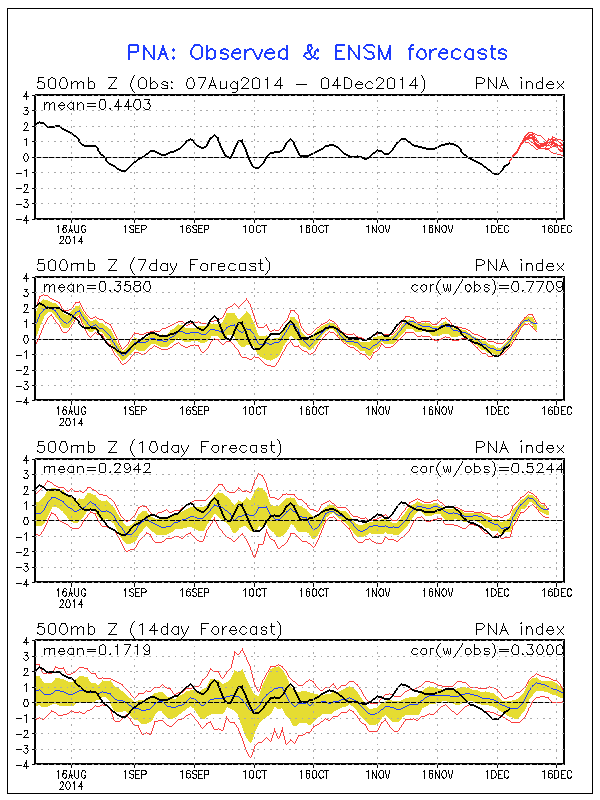
In the short-term, the positive PNA will continue to be the primary driver in our pattern. This will ensure a colder east through the majority of week 1 (through next Friday).
A positive PNA pattern typically leads to below normal heights (trough) and associated cooler than normal pattern across the eastern region.
Modeling sees the cool east in week 1 and warm west- typical of a positive PNA pattern:
There are changes in the mid-range period that’ll have lovers of winter and cold frowning. Many of our long-term readers know how we use the “typhoon rule” as a good indication of what we can expect across our region 6-10 days down the road. As stated multiple times in the past (want to give credit where credit is due), we learned this from the great Joe Bastardi. For those that are new here, I’ll describe this very briefly (you can read through the archives, if you’d like, for a longer/ more detailed description). Typically when you have a recurving typhoon in the WPAC, that suggests a trough (colder pattern) across the central and eastern Lower 48. On the flip side, when you have a westward moving typhoon, that’s a good indication of eastern ridging (warmer pattern).
Courtesy of the Joint Typhoon Warning Center, Super Typhoon Hagupit is forecast to move on a general westward trajectory.
This is a very good sign of a much milder than normal period in the mid-range (days 8-12). Modeling, in return, is going towards a warm pattern (associated ridge) week 2:
The GFS ensembles and NAEFS agree on the warmth and given what we’ve discussed above, so do we:
In fact, it wouldn’t surprise us to see high temperatures in the 55-60 degree range during a day or two week 2.
Really quick and before we end- lovers of winter weather, there’s absolutely NO reason to throw in the towel. In fact, indications in the long range suggest the trough collapses into the east during the week leading up to Christmas and that could provide for all sorts of wintry “mischief” when almost all of folks are wanting snow…
Much more on that in the days ahead. Have a great night!
Still questions around Sunday night snow potential
Even colder air invades early next week
Fun and games continue in the longer range
The afternoon model suite is in in it’s entirety and it leaves us with about as many questions as answers :-)…
Four of our more trusted short-term forecast models are split 50/50 on the outcome Sunday night. In the snowy camp you have the NAM and European. In the drier camp you have the GFS and GEM. Past experience with this type event says the European and NAM solutions may have the better handle and we think the drier modeling will shift a touch northwest with time over the upcoming 24 hours. The difference between camps would be a nice 2-3″ type snowfall for the Monday morning commute across central Indiana versus nothing more than a few flurries. More as the details become clearer…
We still forecast light snow to overspread central Indiana Saturday evening and night. While this won’t be a big deal, a dusting to 1″ of snow is a good bet across most of central Indiana, especially from the I-70 corridor and points north. Roads may be slick in spots on your way to church Sunday morning.
One thing that’s a certainty is that another blast of arctic air will invade along with scattered snow showers early next week. This push of bitter air will be even colder than this weeks.
In the longer term, plenty of wintry “fun and games” remain. In fact, today’s 12z European has the look set to offer more meteorological headaches come late next week. Ah, the season is only beginning… 🙂