With Thanksgiving only 2 weeks from today (incredibly hard to believe), we’re able to start to get a better idea on the overall weather pattern as the “official” kickoff to the holiday season nears. The first point we want to drive home is that we should begin to see a much more active regime evolve during this 2 week period. From a temperature perspective, the pattern overall continues to look milder than average, but there will be a couple opportunities for transient pops of colder air, potentially around the all-important Thanksgiving holiday, itself.
Note how modeling sees the more active pattern evolving over the next 3-4 weeks (green represents above normal precipitation). – A significant change not only for our neck of the woods but certainly for our friends and neighbors down south (badly needed for a region suffering an expanding drought. Speaking of which, all of the dry/ droughty southern tier should reverse in significant fashion as the active Nino storm track gets going over the coming months. As the pattern continues to evolve into the ‘24 spring and summer, the south-central severe drought will be erased.
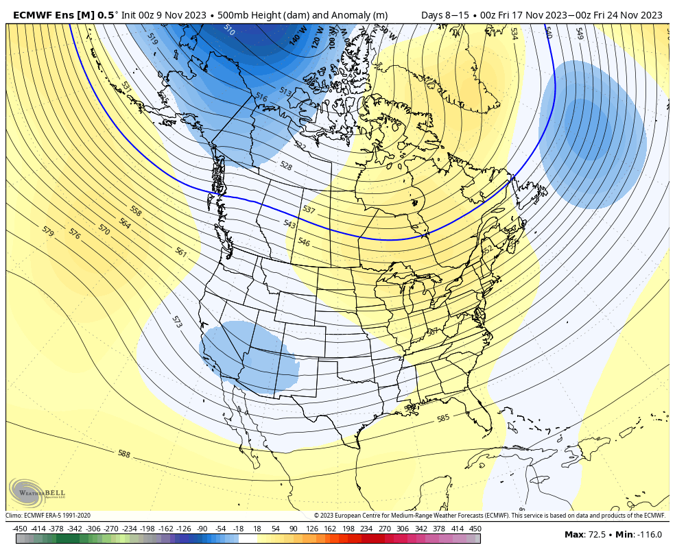
Despite attempts of troughs to roll into the Ohio Valley, they will struggle with staying power over the next 3-4 weeks. The latest JMA Weekly product and Euro/ GFS ensemble blend looks very solid given where the pattern drivers currently reside.
Week 1
Week 2
Weeks 3-4
The pattern drivers of a primarily positive EPO, negative PNA, and MJO in 8/1 (all unchanged from our post earlier this week) all suggest a predominant eastern ridge, western trough placement over the upcoming 2-3 weeks.
We’ll continue to keep close tabs on the regime, especially centered on 11/22 – 11/26.
Make it a great Thursday!
Side note: Confidence is increasing that this Nino will evolve into a central-based event which will up the chances of colder/ snowier prospects come late December and on into January. More on that later next week in a more extensive update specific to this transition.
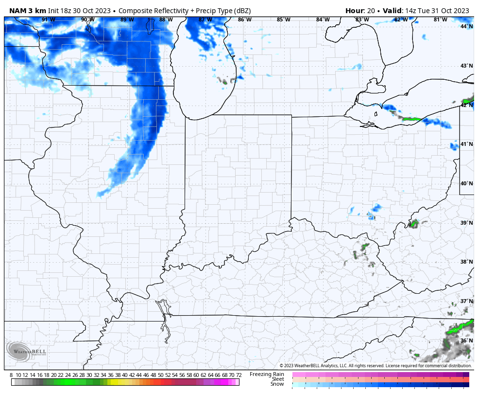
I. Vigorous upper level energy will dive southeast and impact our Halloween weather. Many will see their 1st snowflakes of the season (at least those who didn’t today) tomorrow afternoon and into the evening. This is the type setup that will lead to localized heavier squalls within the broader area of snow showers and I imagine this will carry deep into Tuesday night- longer than what most high resolution guidance currently suggests.
II. Cold and wind will also make for bitter conditions by Halloween standards. Trock or treaters will certainly need the layers under those costumes tomorrow night as wind chills fall into the 10s at times. Gusts up to 30-40 MPH will also create for “spooky” conditions at times.
III. New long range, “seasonal” data continues to suggest we’re heading for a Modoki Nino event. If this does, indeed, verify then we’ll look for colder and potentially snowier trends to take hold (certainly compared to a “traditional” Nino event) towards late December and on into the middle of winter. To no surprise, this should also play into some other drivers that suggest we should see more in the way of high latitude blocking periods this winter, compared to the past few. Stay tuned.
You must be logged in to view this content. Click Here to become a member of IndyWX.com for full access. Already a member of IndyWx.com All-Access? Log-in here.
Though officially, we’re only a couple weeks into autumn, attention here has begun to shift towards the potential predominant pattern as we push into the holiday season.
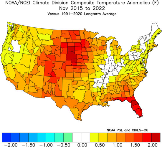
A quick, simple look back over the most recent November and December patterns is a sight that generates anxiety for most winter lovers. At a time when the majority of even non-winter lovers would like snow (i.e. the holidays), well above normal temperatures, and almost record warmth has become all too common over the years.
November 2015-2022
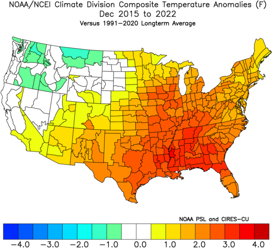
December 2015-2022
Is there reason to believe that could be different this year, especially with our base transition to El Nino? Simply put, not so fast my friend. El Nino winters are notorious for getting off to slower, warm starts. Our research shows that many times November can start cold but that the December pattern flips warmer around these parts. That’s, obviously, not to say it “has” to be that way. Many other factors contribute to the overall regime, but just that when you simply bundle all 1st year Nino events together, it’s more typical than not to find things play out such as illustrated above.
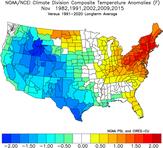
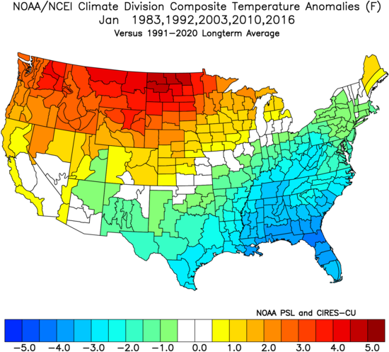
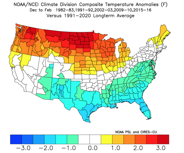
Let’s take a more specific look at our analog package (’82-’83, ’91-’92, ’02-’03, ’09-’10, and ’15-’16) and see what that suggests may be in store as we begin to set our eyes on the holidays.
November: Slightly above normal, locally. Unseasonably cold west and unseasonably warm New England are the headliners.
December: Greatest warm anomalies are centered over the Ohio Valley, in what otherwise is a large-scale warmer than normal regime from the Plains east.
January: The pattern begins to really flip around with cold bleeding southeast as the northern Plains and Northwest turn warmer than normal.
What does this all mean to me? While there’s only one that knows the future, if I was a betting man, I’d lean towards another holiday season that features above normal temperatures and most likely a greater than normal chance of below average December snowfall. I’d anticipate a few cold shots in November and the possibility of one or 2 accumulating snow events that gives way to the overall warmer idea in December. There’s always the chance the pattern begins to shift that last week of December for the colder January look… That’s the hope we’ll leave you with in this post in what otherwise will likely be a warmer than normal month as a whole.
Permanent link to this article: https://indywx.com/trend-hasnt-been-our-friend-as-of-late-around-the-holidays-reason-to-believe-this-year-is-different/
We do it every year around this time and while some years have certainly been tougher than others, there’s always something special about this time on the calendar. Perhaps it’s the cooler days, the longer nights, the return of football season, or better yet the thoughts (at least to this winter lover) of the first flakes of the season that loom in the not too distant future. However you view this time of year, I hope you can find a way to enjoy the upcoming winter season.
Like most years, there will likely be a little something for everyone, and before diving in too far, we always like to remind folks that long range forecasting is always a challenge, albeit a welcome one at that. While there’s simply no way to be certain about specifics 2-5 months in advance, more times than not, we can at least provide an idea of the overall upper pattern that should generate predominant precipitation and temperature regimes in the colder months ahead.
Without further ado, lets dive in…
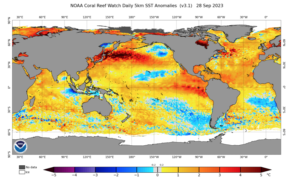
We’re in uncharted territory, at least compared to the past (3) years. After a rare triple dip Nina event, a strong El Nino is here and anticipated to stick around, at least in a moderate fashion, through the winter.
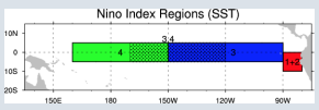
It’s important to note that not one Nino event is identical to another. What’s of particular interest with this year’s event is that a lot of the longer range model guidance begins to weaken the Nino as we get into the middle and latter part of the winter, while migrating the warmest anomalies west (more into the central region: region 3 and region 3.4). By the way, here’s an interesting article that sheds more light on the various regions and indices.
Ultimately, that is the golden ticket to what this winter becomes in my opinion. While far from etched in stone, it’s my belief that when you have a Nino event coming off it’s peak during the winter, there’s a better opportunity to get the warmest anomalies more into the central regions as the weakening takes place. Should this happen then we’re talking about increasing prospects of cold and snow. Meanwhile, if the warmest SST anomalies remain tucked into 1+2, it’ll likely be another ugly winter for snow and cold lovers.
On that note, the past 5 winters have only produced an average 14.1″ of snow in Indianapolis. Only ’20-’21 was close to average at 22.2″. To add salt to the wound, if you take out the record snowiest ’13-’14 (whopping 52.2″), our 10 year snow average is 12.6″.
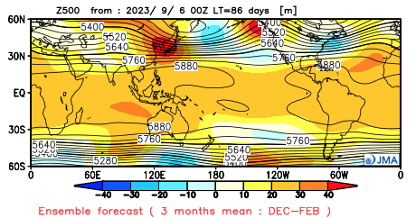
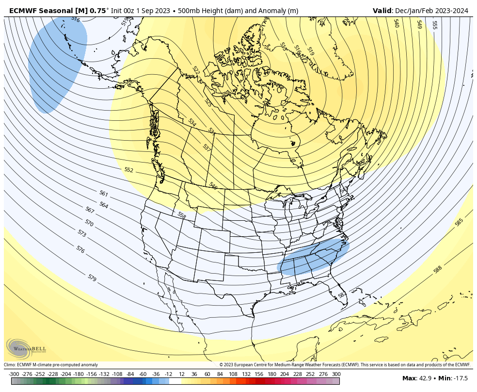
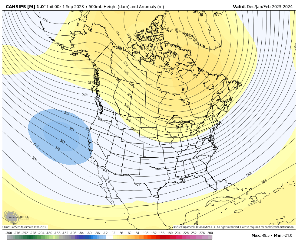
Lets take a look at some of the various modeling for the upcoming meteorological winter (December through February).
JMA Seasonal
European Seasonal
Canadian Seasonal
The seasonal guidance shown above is the most aggressive, collectively, I can recall for quite some time from this distance. Note each of the models above indicate the opportunity for blocking with the active southern stream underneath that we come to expect in an El Nino.
We built our analog set (first shared with Clients on 9/3) with the baseline including 1st year moderate to strong Ninos.
1957-1958
1972-1973
1991-1992
2002-2003
2009-2010
1982-1983
2015-2016
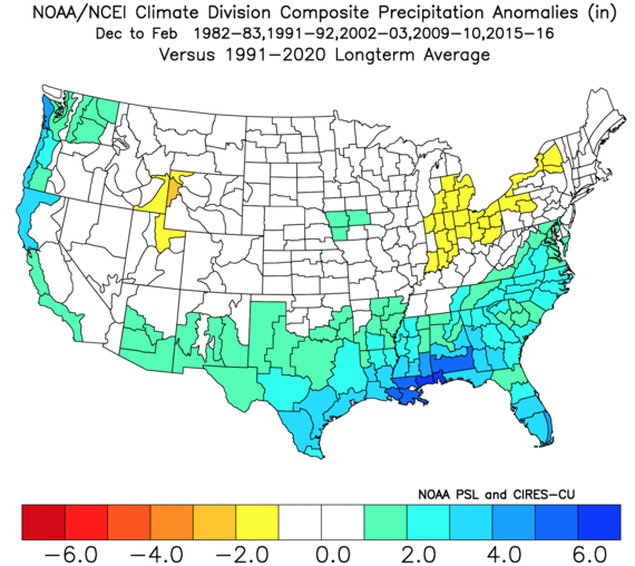
In addition, we’re also looking at critical SST configuration in the NPAC and northwest Atlantic. Out of the list above, heaviest focus centers on ’82-’83, ’91-’92, ’02-’03, ’09-’10, and ’15-’16.
A blend of those years gives us the following temperature and precipitation pattern for meteorological winter:
Temperatures
Precipitation
What does this all mean to me: Central Indiana
Last year we thought the winter would get off to a much quicker, harsher start than years past. While November didn’t disappoint from a snowfall perspective (2.8″ compared to an average of 0.8″), it was still a slightly warmer than normal month. The cold came in December, but it was a “dry” cold with below normal snowfall (1.6″ compared to an average of 6.4″).
The more I look at trends for this winter, the more I like the idea of increased high latitude blocking compared to years past along with the evolving, more central based Nino event. With that said, recent trends have me a bit hesitant to go “all in” on the potential of this winter. We’ll lean slightly warmer than normal with slightly below normal snowfall for the winter as a whole. That said, local perception will be interesting as I envision a snowier winter compared to the past couple years. While the primary storm track should be suppressed this year with below normal precipitation, thanks to the El Nino, that doesn’t necessarily mean we’re in for a snowless winter.
The numbers please…
Temperatures: December through February averaging 0.5° to 1° above normal as a whole
Precipitation: Below normal precipitation is expected through the 3 month winter period (75% of normal is our call) with slightly below normal snowfall. We forecast 20″ of snow (1st flake to last flake).
Whatever the winter provides, I hope you and your family enjoy and stay safe!