Deeper Look Into The Long Range…
You must be logged in to view this content. Click Here to become a member of IndyWX.com for full access. Already a member of IndyWx.com All-Access? Log-in here.
You must be logged in to view this content. Click Here to become a member of IndyWX.com for full access. Already a member of IndyWx.com All-Access? Log-in here.
Before we get into the updated thinking on the pattern, lets review what we have out:
The first week of November has featured an incredibly warm start to the month. (Image courtesy of MRCC).
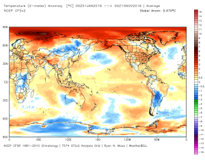
 Speaking of warmth, 2016 has been a very warm year.
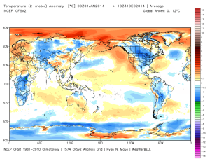
 (The cold of 2014 seems so long ago…)
 Back to present. We’ve targeted the middle part of November to finally beginning “bucking” the recent warm trend. This won’t happen overnight and will be a battle of back and forth, initially. Thus, the “step-down” label. To be clear, November, as a whole, will finish much warmer than average. It’s virtually impossible to counter the incredibly warm start. That said, we do anticipate “jabs” of colder air working in here over the next couple weeks. For instance, this weekend will feature lows in the 20s for most and highs not making it out of the 40s Saturday afternoon. (The average low and high at IND Saturday are 37 and 54).
Despite being in a weak La Nina, the pattern is taking a while to respond. Remember, we’re coming off one of the strongest El Ninos on record. Until we slow the PAC jet, significant, long-lasting, changes won’t occur. We can lean on the AAM (Atmospheric Angular Momentum) forecast for clues as to when this may occur. You can read more about the AAM here. My fellow local weather compadres, Michael Clark, Ed Valley, and Kirk Hinz have also written/ blogged extensively about the AAM and resulting impacts.
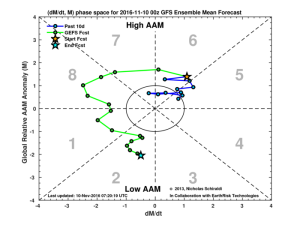
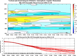 When we look at the AAM forecast (above), we note the westerlies may begin to slow (indicative of the negative values) in the 8-10 day period. This is crucial and, simply put, has to happen for the pattern to begin shifting into more of a position to allow sustained cold to enter the equation. We want to reiterate that this, in and of itself, doesn’t create the cold, but instead allows the pattern to begin shifting away from the Nino-like (warm) regime into more of a La Nina pattern, as a whole. – Hey, you have to start somewhere.
If we can finally get the westerlies to slow, other elements are in play that could (and should) lead to a colder pattern as we move forward. Our (3) big teleconnections are in a position favorable for cold for mid/ late November, into early Dec.
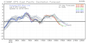
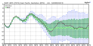
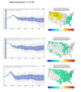 Additionally, the EPO is forecast negative off the GEFS and EPS. (Images courtesy of Weatherbell.com).
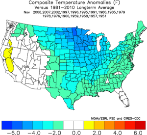
 Again, this is a cold signal. (Image courtesy of Madusweather.com).
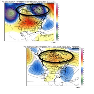
 The ensemble data is also beginning to key-in on higher heights (blocking) developing over the top. Notice the significant changes in the overall look to the pattern between now and days 11-16. (Images courtesy of Weatherbell.com).
 In summary, and in the face of *most* seasonal data that is screaming warm, warm, warm, we still don’t have any significant changes to our overall thinking of “step-down” mid-November giving way to more sustained wintry-like conditions in the overall sense from the Thanksgiving-Christmas period. Time will tell and only the Good Lord knows what the future holds, but we’ve done far too much work and research to throw the “game plan” in the trash before the game even begins…
1.) An absolutely stunning late February day is dialed up, with lots of sunshine and moderating temperatures. We’re going mid 50s this afternoon.

2.) Though warm (lower 60s), Sunday will offer up showers by the afternoon/ evening.

3.) Mid and late week remains a challenge. Do we have a leader-follower situation? Time will tell. We’re still leaning mostly wet for the Tuesday-Wednesday storm for now. The late week system could offer up accumulating snow prospects (ala. ECMWF, GEM).


4.) The period opens warm, but we shift much colder than average by the end of the week.


5.) We continue to look into spring and summer. With the dramatic shift expected to a La Nina, fun times will ensue. Hot, dry summer around these parts followed by a snowy winter? Hmmmm….

Some are beginning to grow tired of the seemingly unending warmth and lack of snow, particularly with an above normal stretch of weather coming that includes the Christmas holiday (though not nearly as warm as the European suggested as soon as only a few days ago).

Our winter outlook stated we thought we’d get off to a warmer than normal start, but we were also very clear in stating we thought a rather marked shift to more sustained wintry conditions loomed for mid and late winter. That period is drawing closer by the day and it’s time to “put up or shut up.” By “mid winter” we mean mid January. Yes, that means three weeks out. Without holding back any punches, we’re fully expecting a colder than average period developing by then (and with staying power), along with plenty of opportunities for wintry precipitation.
The reasoning for our thinking has been outlined in previous posts and in our winter outlook, but, in short, it’s built on the idea of a weakening El Nino and a mean winter upper air pattern that includes W NA ridging (positive PNA regime). Later in the season, a more sustained negative AO and NAO should establish itself that could carry the wintry regime into meteorological spring.

We think we begin to progress into a “step down” process to the pattern explained above through the early stages of January, and the ensemble data is beginning to support this.

The modeled W NA ridging is a far cry from what we’ve been dealing with over the past month.
Now we caution that the initial step down to a more sustained wintry pattern won’t occur overnight. We label it “step down” for a reason. All the while, it’s a start in shifting away from the anomalous warmth we’ve been dealing with through the month of December. Initially, cold air will only be marginal, but as things align into the mid/ late winter pattern and we expand snow cover, arctic air will grow in a more widespread fashion. Something else we’ll begin to have to keep a close eye on? A potentially active NW flow that features several clippers plenty capable of producing accumulating snow. We note central-based Ninos are notorious for the clipper parade during the mid and late winter stretch.
In the shorter term, a rather unsettled Christmas week looms. Modeling will continue to “sure up” the handling of a rather complex storm system after Christmas, as well. We note runs that have pumped out copious rain numbers and others that suggest wintry precipitation may fall as the cold upper low ejects northeast. We’ll continue to monitor.
In the meantime, gear up for a rather wet Monday. We think one half inch is a good bet across the area, with locally heavier totals. Our updated 7-day in the morning will be a rather busy one. Talk with you in the AM!

As we rumble closer to the start of meteorological winter, we wanted to provide some updated thinking around what lies ahead. Before we dig into some of the latest data and dissect the updated SST profile, here’s a recap of our winter outlook posted 10.17.15. You can read the complete outlook here.
At first glance upon looking at the latest SST profile, there aren’t many huge changes from (6) weeks ago. However, there are some interesting trends, mostly pertaining to El Nino region 1+2 versus 3.4.
 1.) In the most recent El Nino monthly recap, Region 1+2 cooled .09 degrees (F) from September to October. Meanwhile, Region 3.4 warmed .32 degrees (F) during the same period. This trend is interesting and something we think continues looking over the data. Central-based, Modoki El Nino events argue for a colder east across a more widespread basis.
2.) The warm, or positive PDO, continues. This argues for eastern cold. Remember the past two winters that ran colder than normal across our region? The positive PDO played a big role in powering those.
3.) Though admittedly much more of a wild card, the current SST configuration in the northern Atlantic continues to argue for a developing negative NAO as mid and late winter arrives. Personally we feel the NAO impact, locally, is felt more in the later winter period. A negative NAO would also argue for colder than normal.
The latest Sea Surface Temperature Constructed Analog (SSTCA) model is in and remains firm on the idea of a cold east and south.


As we move into the Thanksgiving and Christmas seasons, rest assured we’ll continue to keep close tabs on the “sensible” weather the evolving pattern will deal the region. As a whole, we feel confident we remain on the right track and think plenty of wintry “fun and games” lie ahead this year.
Here’s a photo from Christmas 2007 out in Breckenridge, CO with my brother. Could this be the scene for Christmas this year here? “I’m dreaming of a white Christmas…”
