Client Brief: Thursday Severe Weather Update…

Type: Damaging Winds And Severe Potential
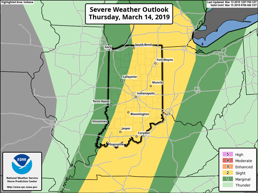
What: All modes of severe weather, including tornadic potential. Damaging wind gusts.

When: Damaging wind gusts develop late tonight into the predawn Thursday. Severe storms are most likely Thursday afternoon into early Thursday evening.

Wind: SW 45-55 MPH with gusts of 60 MPH+
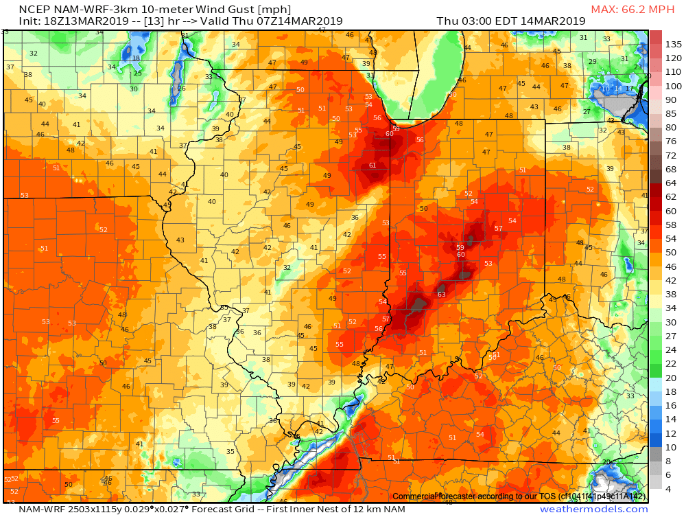
Winds will begin to gust to potentially damaging levels during the overnight tonight.

A couple of rounds of thunderstorms will impact central Indiana during the overnight and again Thursday afternoon and evening. It’s the second round tomorrow afternoon that has us most concerned for the potential of strong to severe thunderstorms. A lot of this hinges on just how much clearing takes place from the morning round of showers and embedded thunder. Should we clear things out in significant fashion, and introduce some sunshine, the threat of severe weather tomorrow afternoon will grow significantly. Conversely, should we hold onto a mostly overcast sky, this will limit the overall severity of afternoon storms. The sun would help destabilize things in rather rapid fashion and given some of the other parameters in place, would lead to all modes of severe weather with storms that develop tomorrow afternoon- including large hail and tornadoes.

Additionally, due to the sheer strength of the storm system, damaging winds are still in play tomorrow (even outside of thunderstorms). In fact, winds will begin to gust upwards of 50 MPH+ during the overnight period tonight. If you haven’t already, please take the time now to tie down or secure loose objects to keep them from being blown about in the wind.

Conditions will begin to improve as early as tomorrow night, although we’ll turn much colder. Air will grow cold enough to promote “wrap around” moisture to fall in the form of snow by Friday afternoon.

Threat of strong to severe storms will be greatest Thursday afternoon into the early evening hours.

Client Brief: Snowfall Update…

Type: Accumulating Snow

What: Accumulating snow

When: Thursday afternoon into Friday morning

Temperatures: Upper 20s to near 30

Wind: E 5-10 MPH

Blowing/ Drifting: Non-existent to minimal


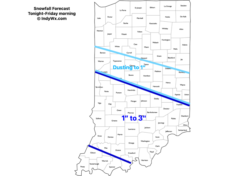
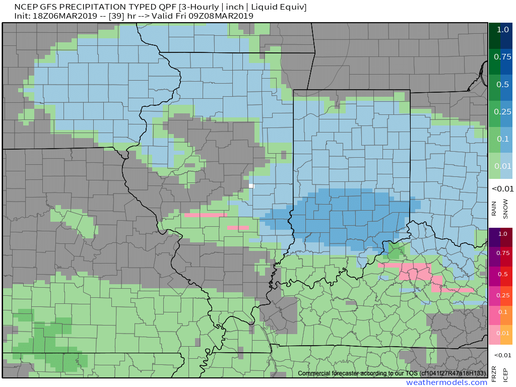
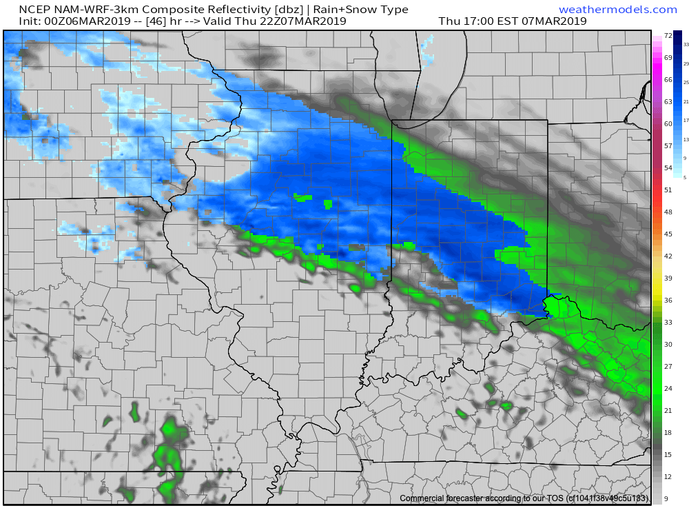
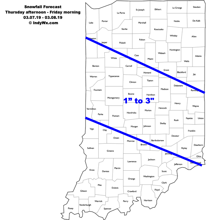
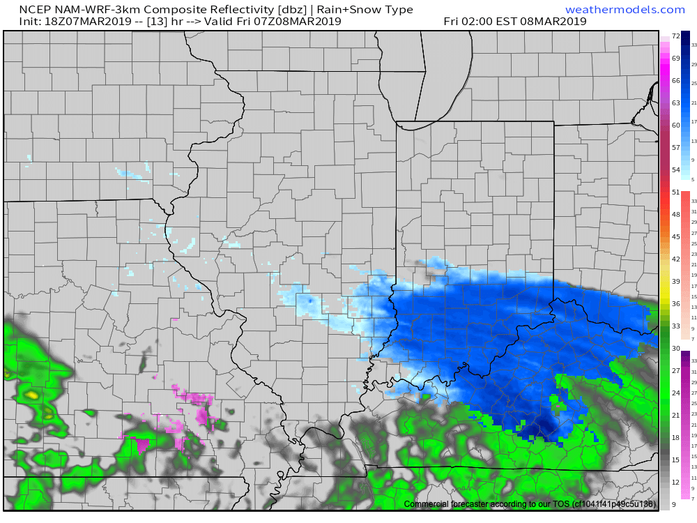
Computer guidance has continued to shift the swath of 1″ to 3″ of snow south over the past 12 hours. Accordingly, we’ve shifted things south about 3-4 county rows with our updated snowfall forecast this evening. The steadiest snowfall will occur during the overnight hours into the predawn Friday. For places around Indianapolis and points north, this won’t be a significant event, however, if your travels take you south, roadways are expected to become slick and hazardous tonight into Friday morning. Improving conditions will develop by late morning into Friday afternoon as temperatures “warm” above the freezing mark. Highs tomorrow will top out in the upper 30s to lower 40s with significant melting expected by afternoon.

Confidence: High

(We’ll have our updated long range forecast online later tonight).

Running the Gamut; Looking Ahead to April…

We’ll apologize in advance for the long-winded post tonight, but there’s a lot to cover. Not only do we have the accumulating snow on deck, a couple of strong storm systems this weekend into the middle of next week, but the long range pattern is set to turn cold (again) after a mid-month respite. We also want to look ahead to our early thoughts towards April…

Let’s take things one at a time:

Thursday-Friday Snow

While we don’t have major changes to our ongoing snowfall forecast, we have “sagged” the swath of 1″ to 3″ snow south just a hair given the latest computer model guidance. Steadiest snow should fall Thursday night into the predawn hours Friday. We’d anticipate a slick Friday morning commute through the heart of central Indiana.

Snow should exit off to the southeast around, or just before, lunchtime Friday. As always, your ground-truth reports are welcome (feel free to send to us on Twitter or via e-mail).

Warmer Side Of Things

The ‘mean’ trough position will shift to the west (temporarily) and lead to an overall milder time of things for the mid-month stretch. Unfortunately, the milder air will come with a wetter pattern.

This milder, wetter pattern will be highlighted by (2) storms:

I. Saturday, 3/10

II. Tuesday-Wednesday, 3/12-3/13

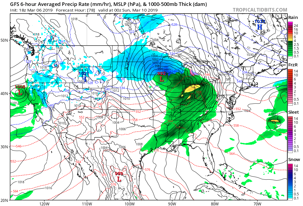
Both storm systems will be capable of producing locally heavy downpours and embedded thunder. Greatest chances of severe will remain south of central IN with this weekend’s storm, but may be further north next week. We’ll keep a close eye on things and issue Client Briefs if need be as we get closer.

A combination of the GFS and European computer models print-out rainfall totals between 1″ and 2″ over the upcoming 10-days and this seems reasonable given the fact both storm systems will be able to tap into Gulf of Mexico moisture.

From a temperature perspective, the brutal cold will come to an end behind our late week snowmaker. While “transient” chill will follow both of the upcoming storm systems, we’re heading into a much milder pattern, overall, through the mid-March stretch. Mildest air will come directly in front of the storm systems, highlighted by a couple of 60 deg. + days the middle of next week.

Positive PNA takes over

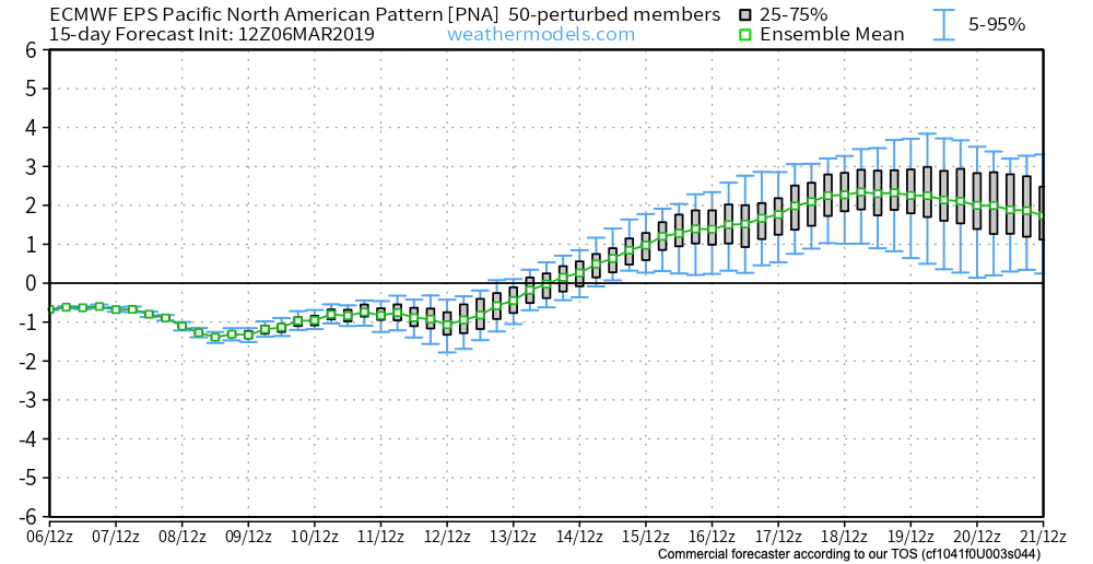
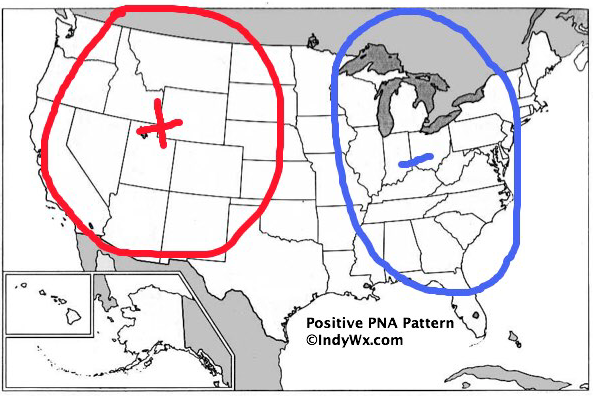
Unfortunately (for lovers of spring), the mid-month warm-up will be only a “tease” as we’re set to trend cooler, relative to normal, for the last 10 days of the month. The reason? A developing positive PNA.

To no surprise, we see the cooler pattern returning on the computer models:

Not only will we turn colder to close the month, but Thursday likely won’t be our last accumulating snow of the season…

Looking Towards April

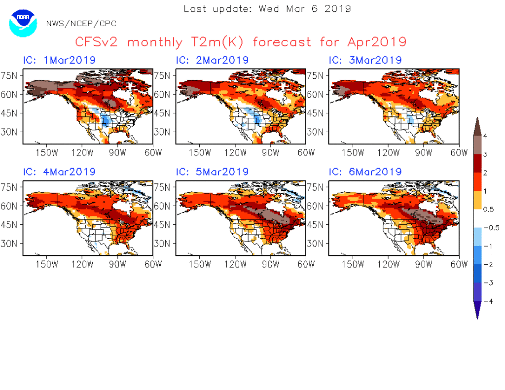
Despite the late-March “set back” to a chilly time of things, we continue to think a more sustained “stick and hold” spring pattern looms around the corner. In fact, we agree with the latest CFSv2 delivering a warmer than normal pattern for April, as a whole, to the eastern portion of the country.

Note that as we go, the model is getting warmer for April with each passing day. As things stand now, we think the trough will pull back to the west with a more sustained ridge in place across the eastern portion of the country in April. With this, a wetter than average regime likely awaits, including an uptick in severe chances further north into the region.

All-Access Client Brief: Stripe Of Accumulating Snow Streaks Across Central IN…

Brief: Accumulating Snow

What: Accumulating snow

When: Thursday afternoon into Friday morning

Temperatures: Upper 20s to near 30

Wind: E 5-10 MPH

Blowing/ Drifting: Non-existent to minimal

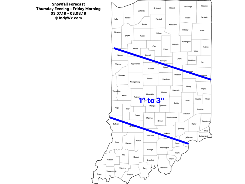
Snow will develop to our northwest tomorrow night into Thursday morning before streaking southeast across central Indiana Thursday afternoon into Friday morning. The heaviest snowfall is expected to occur Thursday afternoon into the evening hours with lighter snow falling Thursday night into Friday morning. Despite what should be moderate intensity at times, the higher March sun angle should help with accumulation on area roadways (still expecting slick and slushy travel at times during periods of heavier intensity) and the idea here is that a general 1″ to 3″ swath of snow falls in a northwest to southeast orientation during the period. Temperatures should remain fairly steady or slowly fall into the upper 20s and winds are expected to be light.

Confidence: Medium-high

Next Update: 7a Wednesday

All-Access Client Brief: Morning Thoughts After Looking Over The Latest Data For Sunday…

Brief: Accumulating snow

Forecaster: McMillan

What: Accumulating snow

When: 6a to 6p Sunday

Temperatures: Upper 20s to near 30

Wind: North 10-20 MPH

Blowing/ Drifting: Minimal to moderate

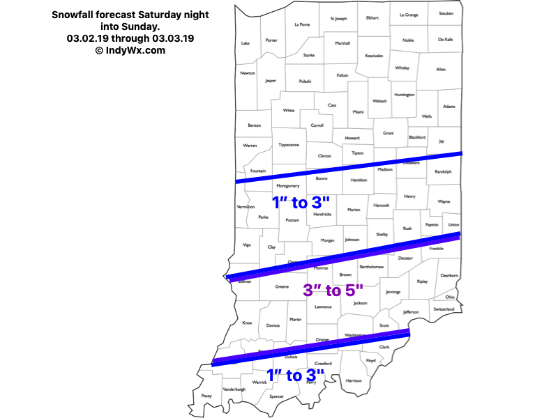
Right off the bat, there’s no need to make any changes to our ongoing snowfall forecast. Snow will arrive into south-central Indiana before sunrise Sunday before expanding northeast through the morning hours, including Indianapolis by mid-to-late Sunday morning. Greatest potential of embedded heavier banding continues to look like it’ll lie across south-central parts of the state (thus the continuation of a 3″ to 5″ swath of snow). North winds will turn gusty Sunday evening and a bit of blowing/ drifting is possible on east-west roadways Sunday night as the late season arctic air arrives in earnest.