Category: Christmas/ Thanksgiving

Turning Colder Later Today; Keeping Close Tabs On The Weekend…

Tue.

Wed.

Thr.

Fri.

Sat.

Sun.

Mon.

 Status-weather-showers-scattered-icon

 Status-weather-clouds-icon

 Status-weather-clouds-icon

 images

 Status-weather-snow-scattered-icon

 Status-weather-clouds-icon

 Status-weather-clouds-icon

34/ 46

28/ 34

23/ 32

27/ 35

29/ 33

29/ 36

27/ 37 

Highlights:

  • Tuesday Showers
  • Weekend Snow For Some
  • Pre-Christmas Wintry Event

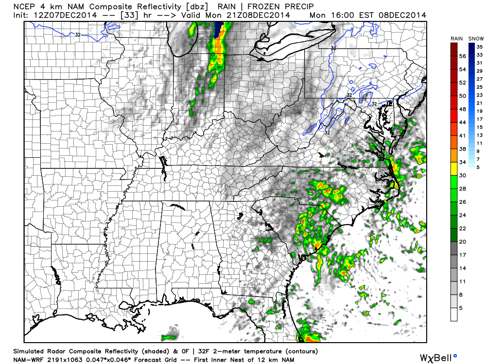
Showers; Turning Colder Late…Showers will remain in our forecast today.  Most widespread rain will occur during the early morning hours, but we’ll maintain mention of light showers in our forecast even into the afternoon.  Winds will be gusty and help drive colder air into central Indiana later this evening.  We forecast nearly steady temperatures during the morning and afternoon hours before falling temperatures during the evening.

Dry, But Cold Mid Week…We’ll welcome a drier regime for the midweek period, along with partly to mostly cloudy skies and colder conditions.

Eyeing The Weekend…There’s not much change in our overall thinking of a potentially snowy first half of the weekend for some.  Monday featured run-to-run inconsistencies on our weekend storm system and we fully expect additional changes within the model data during the next couple of days.  In building our forecasts we factor in current data, but also rely on past data of storm tracks with similar setups.

At the end of the day (and despite model inconsistencies) we still think one area of low pressure heads northeast out of the mid MS River Valley into the Ohio Valley Friday night into Saturday.  A secondary area of low pressure is then expected to organize along the mid Atlantic coast Saturday afternoon.  Widespread light snow should build into the Ohio Valley Saturday with the above set up.  Exactly where heavier snow sets up is still up for much debate and will require fine tuning as we move forward.

Christmas Travelers Keep Close Tabs On The Forecast…After our first opportunity of potential wintry weather we’ll enjoy only a day or two of calmer weather in between storms.  Longer range data suggests we need to keep abreast of another winter event just prior to Christmas.

Upcoming 7-Day Precipitation Forecast:

  • 7-Day Rainfall Forecast: 0.25″ – 0.50″
  • 7-Day Snowfall Forecast: 1″ – 2″

Permanent link to this article: https://indywx.com/3276/

Busy Week Ahead…

Mon.

Tue.

Wed.

Thr.

Fri.

Sat.

Sun.

 Status-weather-showers-scattered-icon

 Status-weather-showers-scattered-icon

 Status-weather-clouds-icon

 Status-weather-clouds-icon

 images

 Status-weather-snow-scattered-icon

 Status-weather-clouds-icon

40/ 50

33/ 45

25/ 35

25/ 35

25/ 34

28/ 32

26/ 33 

Highlights:

  • Early Week Rain Maker
  • Keeping An Eye On Mid Week
  • Weekend Winter Storm For Some

Early Week Storm System…An area of low pressure will scoot though the Ohio Valley Monday into Tuesday delivering showers to the region. We forecast rain to arrive late morning to early afternoon Monday across central Indiana. We’re not expecting heavy rain, but plan on taking the rain gear with you as you leave for work and/ or school.  Colder air will filter into the state Tuesday afternoon setting up a cold mid week period.

Some forecast models have hinted at the threat of light wintry precipitation Wednesday into Thursday, but for now we’re keeping this out of our official forecast and instead going with a mostly cloudy, but dry mid week period.

Developing Weekend Winter Storm…All eyes will focus on a significant weekend winter storm event.  Details on track are still up for debate with this being in the mid range period and we’ll keep close tabs as we move forward through the week.  As of now we forecast increasing clouds through the day Friday with light snow developing late Friday night and continuing into Saturday.  Snowfall totals will obviously depend on the track of the low and we’re still a few days away from being able to provide any sort of specific accumulation ideas.  Guidance right now ranges from a “plowable” event to one that misses us to the south and east.  Stay tuned.

The weather pattern continues to look cold and active in the days leading up to, and through, the Christmas and New Year’s period.  Buckle up for a fun ride…

Upcoming 7-Day Precipitation Forecast:

  • 7-Day Rainfall Forecast: 0.25″ – 0.50″
  • 7-Day Snowfall Forecast: 1″ – 2″

Permanent link to this article: https://indywx.com/busy-week-ahead/

“I’m Dreaming Of A White Christmas…”

Modeling continues to suggest a cold and wintry time lies ahead as we progress into and through the special Christmas period. Could this be the scene across central Indiana Christmas…

You must be logged in to view this content. Click Here to become a member of IndyWX.com for full access.  Already a member of IndyWx.com All-Access?  Log-in here.

Permanent link to this article: https://indywx.com/im-dreaming-of-a-white-christmas/

Sunday Morning Rambles…

1.) It’s nice to see the sun for once.  While we’ll still have mid and high level cloudiness to deal with later today, we’ll gladly take what we can get of the good ole vitamin D this time of the year!

20141207_1445_EVV_vis

2.) Rain over the Thursday-Friday period followed along very closely to what modeling suggested.  Heaviest rains fell central and south.

nws_precip_ky_3

3.) A cold front will move through Monday evening with a few showers, gusty winds, and set up a cold week, overall.

hires_ref_ky_34

4.) In the long range, we continue to really like the looks of things from a winter weather lover’s point of view.  Undercutting jet supplying storm potential, arctic intrusion, and a blocky look… Details will have to be sorted through as time draws closer, but from this perspective, the pattern continues to look like it’s heading towards one capable of widespread colder than normal air and winter storm potential Christmas week.

122014SetUp

Permanent link to this article: https://indywx.com/sunday-morning-rambles-3/

Short-term Cold; Mid-range Warm…

There’s been a ton of conversation as of late about where this overall weather pattern is heading.  Perhaps it’s the Christmas season that brings out the conversation as everyone is hoping for that cold pattern to provide a White Christmas.

While in the short-term cold will continue to dominate, we’re becoming increasingly confident of an unseasonably mild stretch of air in the mid-range period.  That’ll take us up to the week before Christmas…

In the short-term, the positive PNA will continue to be the primary driver in our pattern.  This will ensure a colder east through the majority of week 1 (through next Friday).

pna.sprd2

A positive PNA pattern typically leads to below normal heights (trough) and associated cooler than normal pattern across the eastern region.

A positive PNA pattern typically leads to below normal heights (trough) and associated cooler than normal pattern across the eastern region.

Modeling sees the cool east in week 1 and warm west- typical of a positive PNA pattern:

gefs_t2anom_by5_conus_29

There are changes in the mid-range period that’ll have lovers of winter and cold frowning.  Many of our long-term readers know how we use the “typhoon rule” as a good indication of what we can expect across our region 6-10 days down the road.  As stated multiple times in the past (want to give credit where credit is due), we learned this from the great Joe Bastardi.  For those that are new here, I’ll describe this very briefly (you can read through the archives, if you’d like, for a longer/ more detailed description).  Typically when you have a recurving typhoon in the WPAC, that suggests a trough (colder pattern) across the central and eastern Lower 48.  On the flip side, when you have a westward moving typhoon, that’s a good indication of eastern ridging (warmer pattern).

Courtesy of the Joint Typhoon Warning Center, Super Typhoon Hagupit is forecast to move on a general westward trajectory.

wp2214

This is a very good sign of a much milder than normal period in the mid-range (days 8-12).  Modeling, in return, is going towards a warm pattern (associated ridge) week 2:

test8

The GFS ensembles and NAEFS agree on the warmth and given what we’ve discussed above, so do we:

2014120412_054@007_E1_north@america_I_NAEFS@TEMPERATURE_anomaly@probability@combined@week2_186

D12

In fact, it wouldn’t surprise us to see high temperatures in the 55-60 degree range during a day or two week 2.

Really quick and before we end- lovers of winter weather, there’s absolutely NO reason to throw in the towel.  In fact, indications in the long range suggest the trough collapses into the east during the week leading up to Christmas and that could provide for all sorts of wintry “mischief” when almost all of folks are wanting snow…

Much more on that in the days ahead.  Have a great night!

Permanent link to this article: https://indywx.com/short-term-cold-mid-range-warm/