Short-term Cold; Mid-range Warm…

There’s been a ton of conversation as of late about where this overall weather pattern is heading.  Perhaps it’s the Christmas season that brings out the conversation as everyone is hoping for that cold pattern to provide a White Christmas.

While in the short-term cold will continue to dominate, we’re becoming increasingly confident of an unseasonably mild stretch of air in the mid-range period.  That’ll take us up to the week before Christmas…

In the short-term, the positive PNA will continue to be the primary driver in our pattern.  This will ensure a colder east through the majority of week 1 (through next Friday).
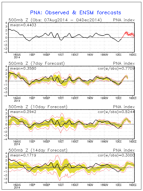
pna.sprd2

A positive PNA pattern typically leads to below normal heights (trough) and associated cooler than normal pattern across the eastern region.

Modeling sees the cool east in week 1 and warm west- typical of a positive PNA pattern:

gefs_t2anom_by5_conus_29

There are changes in the mid-range period that’ll have lovers of winter and cold frowning.  Many of our long-term readers know how we use the “typhoon rule” as a good indication of what we can expect across our region 6-10 days down the road.  As stated multiple times in the past (want to give credit where credit is due), we learned this from the great Joe Bastardi.  For those that are new here, I’ll describe this very briefly (you can read through the archives, if you’d like, for a longer/ more detailed description).  Typically when you have a recurving typhoon in the WPAC, that suggests a trough (colder pattern) across the central and eastern Lower 48.  On the flip side, when you have a westward moving typhoon, that’s a good indication of eastern ridging (warmer pattern).

Courtesy of the Joint Typhoon Warning Center, Super Typhoon Hagupit is forecast to move on a general westward trajectory.

wp2214

This is a very good sign of a much milder than normal period in the mid-range (days 8-12).  Modeling, in return, is going towards a warm pattern (associated ridge) week 2:

test8

The GFS ensembles and NAEFS agree on the warmth and given what we’ve discussed above, so do we:

2014120412_054@007_E1_north@america_I_NAEFS@TEMPERATURE_anomaly@probability@combined@week2_186

D12

In fact, it wouldn’t surprise us to see high temperatures in the 55-60 degree range during a day or two week 2.

Really quick and before we end- lovers of winter weather, there’s absolutely NO reason to throw in the towel.  In fact, indications in the long range suggest the trough collapses into the east during the week leading up to Christmas and that could provide for all sorts of wintry “mischief” when almost all of folks are wanting snow…

Much more on that in the days ahead.  Have a great night!

Catching Up And Looking Ahead…

From the IndyWx.com family to yours, we wish you a very happy Thanksgiving! Thank you for taking the time to read our content daily and for all of your support…

You must be logged in to view this content. Click Here to become a member of IndyWX.com for full access.  Already a member of IndyWx.com All-Access?  Log-in here.

Cold Thanksgiving…

Thanksgiving

Fri.

Sat.

Sun.

Mon.

Tue.

Wed.

 Status-weather-snow-scattered-day-icon

 Status-weather-snow-scattered-day-icon

 Status-weather-showers-scattered-icon

 Status-weather-showers-scattered-icon

 Status-weather-clouds-icon

 Status-weather-clouds-icon

 Status-weather-showers-scattered-icon

24/ 32

19/ 36

30/ 54

54/ 60

28/ 54

24/ 41

34/ 50 

Happy Thanksgiving…We want to wish each and every one of you a happy and healthy Thanksgiving!  Enjoy the day with family and friends.  We’re incredibly thankful and blessed for your support and to be able to provide you with the latest weather forecasts and discussions throughout central Indiana.  While the morning could offer a few flurries or scattered snow showers, most of the day will be dry and cold.  Average highs are in the upper 40s this time of year.  We’ll fall far below that this Thanksgiving.

Moderating Into The Weekend…Black Friday will continue the cold theme along with a few snow flurries as a weak weather system scoots through the region.  Shoppers will certainly want to bundle up as they tackle those Christmas lists.  That said, the theme of the Thanksgiving weekend will be one that features moderating temperatures.  The milder southwesterly air flow will also serve to provide increasingly cloudy conditions along with pesky light rain late Saturday into Sunday.

Challenging Forecast…A challenging forecast is ahead early next week as cold highs to the north combine with resurgent milder air across the south.  The battle ground lies across the Mid West and Ohio Valley region and we’ll have to remain on our toes for potential changes.  For now we’re going with a colder feel Monday (falling temperatures after a high in the wee morning hours), cold and dry Tuesday, and milder/ wet Wednesday.  Stay tuned.

News and Notes: We’re very excited to let you know that Bill will be joining Ray Steele on Weekend Indiana Saturday morning to talk a little weather and a lot about the Iron Bowl!  Be sure to tune into WIBC 6a-8a Saturday.

Upcoming 7-Day Precipitation Forecast:

  • 7-Day Rainfall Forecast: 0.50″
  • 7-Day Snowfall Forecast: Trace – Dusting

Happy Thanksgiving; Important Travel Weekend…

A nor’easter is making a mess of travel (in the air and on the road) up and down the east coast. Also note the clipper system digging through the mid…

You must be logged in to view this content. Click Here to become a member of IndyWX.com for full access.  Already a member of IndyWx.com All-Access?  Log-in here.

Cold Thanksgiving Ahead…

Tue.

Wed.

Thanksgiving

Fri.

Sat.

Sun.

Mon.

 Status-weather-clouds-icon

 Status-weather-snow-scattered-day-icon

 Status-weather-snow-scattered-day-icon

 Status-weather-clouds-icon

 Status-weather-showers-scattered-icon

 Status-weather-showers-scattered-icon

 Status-weather-showers-scattered-icon

28/ 34

25/ 37

26/ 34

24/ 39

35/ 52

47/ 53

33/ 47 

Much Colder Than Normal; Light Snow Southwest…It’s only fitting that we’ll roll into the Thanksgiving holiday with the same overall weather theme we’ve dealt with for the month of November- MUCH colder than normal.  Dry skies can be expected today (with the exception of a few morning flurries).

Our next weather maker will scoot southeast and impact primarily the far southwestern portions of the region with light snow Wednesday (dusting to less than 1″ of accumulation).  A quick note- these type systems have been known to “overachieve” from time to time and we’ll keep a close eye on things the next 24 hours.

A few scattered snow showers/ flurries will be possible across central Indiana Wednesday into Thanksgiving Day, but shouldn’t amount to much.  Cold will be the big weather story.  Plan to have plenty of fire wood ready to keep a roaring fire going through the Thanksgiving get-togethers.

Black Friday shoppers can expect dry conditions and colder than normal weather continuing, but temperatures will begin to moderate after a cold and frosty start.

Warming Up…Our cold weather pattern will relax as we open up December and provide a taste of the November we never had (temperature-wise, at least :-)).  In fact, a 60 degree reading is possible later next week as a warmer southwesterly air flow takes control.  With the southwesterly flow in place, moisture will increase and we’ll mention the chance of light rain in our weekend forecast.

Upcoming 7-Day Precipitation Forecast:

  • 7-Day Rainfall Forecast: 0.50″
  • 7-Day Snowfall Forecast: Trace – Dusting