Category: Christmas/ Thanksgiving

Thanksgiving Storm System And December Pattern Rambles…

Updated 11.21.22 @ 6:37p

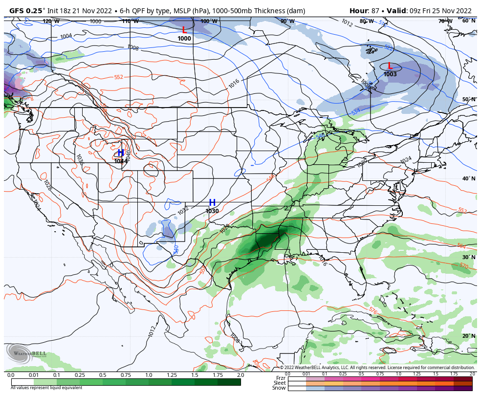
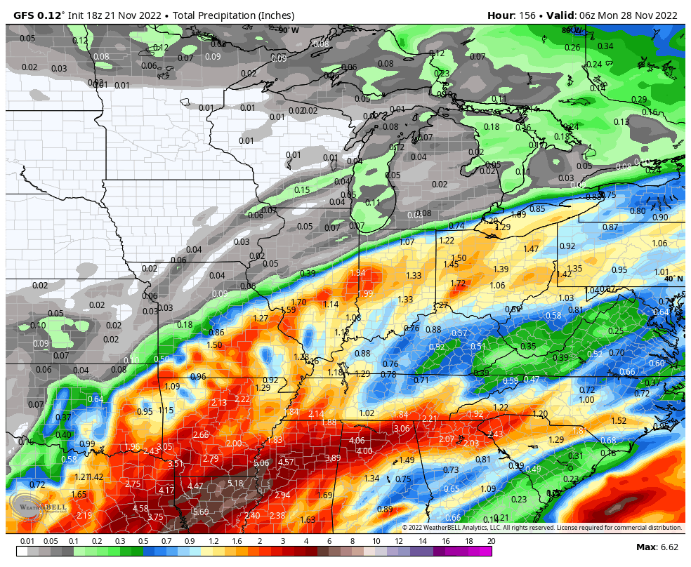
It only took a week to 10 days, but model guidance is FINALLY starting to align on our Thanksgiving storm, and it’s for a more drawn out period of wet, unsettled weather through the Thanksgiving weekend. We still believe clouds will increase through the day on Thanksgiving with light rain moving into central Indiana Thursday evening/ night. The initial surge of moisture should move out of the area early on Black Friday. Early thoughts are for this lead wave to deposit between 0.10″ and 0.25″ for most.

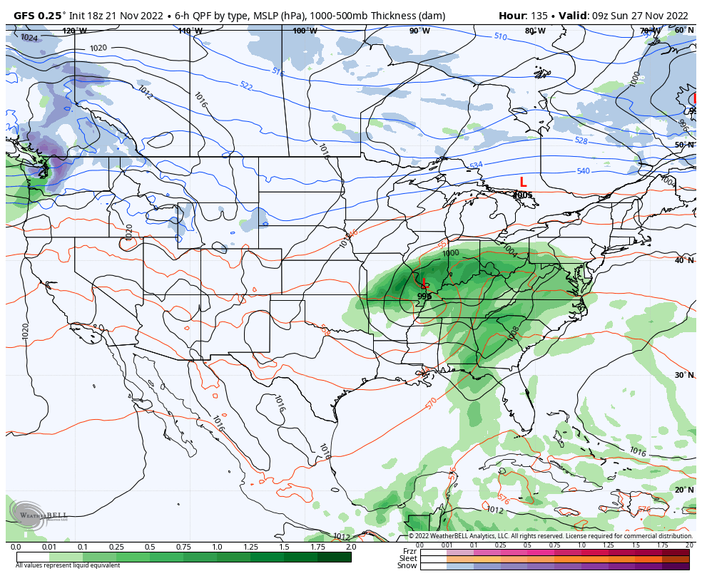
Most, if not all, of our Black Friday and through the daytime Saturday currently looks on the dry side. While we’ll still have considerable cloudiness, the next round of moisture (this of a much heavier variety) is dialed up Saturday evening into Sunday as a surface low moves from the Ark-la-tex region, northeast into the central and eastern Ohio Valley. A 1″ to 2″ soaker appears in order from a standpoint of total rain with this system.

Once the system departs to the northeast, unlike the past couple of events, milder air will take hold to close November and open December. In fact, multiple days with highs into the 60s are a good bet 12/1 through 12/5.

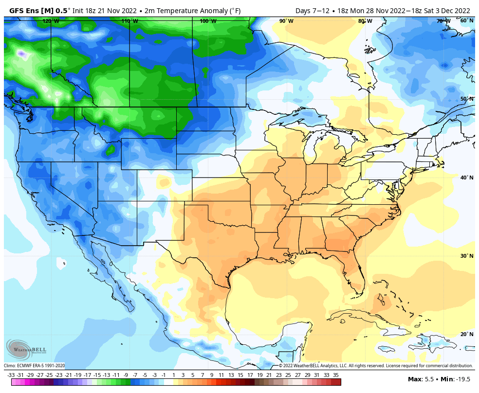
In the face of the warm open to the month, there’s no flinching in our long standing idea of an overall colder/ snowier than normal December, locally. We note the EPO is forecast negative down the road and combine this with what continues to look like a favorable (at least if you’re a winter fan) MJO, the thought here remains squarely on the return of colder, more wintry times after the first few days of the month…

Permanent link to this article: https://indywx.com/thanksgiving-storm-system-and-december-pattern-rambles/

Long Winded Long Range Update And Looking Over The Latest Data For Thanksgiving…

Updated 11.17.22 @ 8p

You must be logged in to view this content. Click Here to become a member of IndyWX.com for full access.  Already a member of IndyWx.com All-Access?  Log-in here.

Permanent link to this article: https://indywx.com/long-winded-long-range-update-and-looking-over-the-latest-data-for-thanksgiving/

VIDEO: Short-Term Snow Update; Pattern Drivers That Should Dominate The Bulk Of This Year’s Holiday Season…

Updated 11.15.22 @ 7:43a

You must be logged in to view this content. Click Here to become a member of IndyWX.com for full access.  Already a member of IndyWx.com All-Access?  Log-in here.

Permanent link to this article: https://indywx.com/video-short-term-snow-update-pattern-drivers-that-should-dominate-the-bulk-of-this-years-holiday-season/

‘Mean’ Early Winter Pattern Showing Itself Over The Next Couple Weeks?

Updated 11.11.22 @ 7:46a

As we “set the stage” over the upcoming week, we must start with the strong cold front that will push east across the state this afternoon. Temperatures will begin to fall by mid to late afternoon before “dropping off the cliff” tonight. 🙂 I think we’ll be hard pressed to experience temperatures anywhere close to the relative mild air that we’re still enjoying the morning, at least through Thanksgiving.

This is all part of the leading edge of a significantly colder pattern moving east, and this is a pattern that has staying power. Considering how warm we’ve been to open November, it’ll come as a shock to some.

Perhaps more interesting to some are the prospects of wintry precipitation. There’s growing indication that the primary storm track may, indeed, take a favorable position for early wintry “fun and games” across the Ohio Valley, including central Indiana over the course of the next couple weeks as a whole.

The first feature is one that has a looks of an “over-achiever” and it’ll arrive as early as tomorrow morning. This is thanks to a couple features: a surface wave trailing the base of an eastward progressing trough, along with a piece of upper level energy diving southeast across the upper Midwest and western Great Lakes. The 2 features will allow an expanding area of snow to blossom across the state (focusing on central and eastern Indiana) tomorrow morning and this should accumulate in spots, especially on grassy areas: 0.50” to 1.5”. Despite relatively warm ground temperatures, the expected timing of the snowfall and intensity should be enough to generate the aforementioned accumulation numbers for places like Indianapolis, Muncie, Greensburg, and surrounding areas.

An expanding area of snow will move across central and eastern IN Saturday morning.

“System snow” will then be followed by wind-whipped scattered lake-enhanced snow showers Saturday evening. These will be most numerous across northern IN but a few will sneak into central and southern IN as well.


If this isn’t enough for you snow lovers out there, keep an eye on 2 systems next week: Tuesday into Wednesday and again late next weekend.

I still don’t think modeling has come around to the correct idea of handling the southern stream energy associated with the Tuesday system. While there isn’t any reason to get overly cute with this one from this distance, we’ll want to keep close attention for the chance of additional accumulating snow potential Tuesday.

Finally, at least from this distance, it appears as if there may be some additional chances of wintry precipitation Thanksgiving week.

Not a bad pattern by November standards, huh? That is at least if you’re a winter weather fan…

Permanent link to this article: https://indywx.com/mean-early-winter-pattern-showing-itself-over-the-next-couple-weeks/

The Transition To Winter…

Updated 11.06.22 @ 10:47a

“Wintry” is certainly not a word that comes to mind when describing the first week of November ‘22. Indianapolis is running a whopping 11.4° above normal month to date.

The upcoming several days will feature additional well above normal warmth, including highs in the mid 60s to around 70°. The reasons behind the warmth have been well advertised between the MJO and teleconnections. This is all part and parcel to the SST configuration, including the 3rd consecutive La Niña fall.

But things are changing now and arriving right on schedule. It’s wild, really, when you think of the ability to find answers to the future (upcoming pattern evolution) by looking back at the past.

We note the teleconnections are now beginning to align in a manner that will drive colder than normal conditions east. The MJO also has a look that will try and circle back into Phase 6 mid to late month. To add to the complexity of the pattern transition, a late season hurricane will likely hit the Florida peninsula mid to late week before recurving up the eastern seaboard.

A cold front will blow through the state Friday and while it’ll likely be moisture starved, unlike this past front, there will be a sharp temperature drop behind the frontal passage over the weekend.

How about a week from today highs are only in the mid-upper 30s and lows may dip into the upper 10s and lower 20s. Indications are that the overall colder than normal regime will have staying power, too. While wholesale pattern transitions can be finicky at the onset, there’s a belief on this front that the overall regime will feature more sustainable cold and eventually opportunities for wintry precipitation as we close November and open up December.

There’s no change to the ideas here of the bulk of the holiday season this year (Thanksgiving to New Years) providing above normal snowfall and below normal temperatures. At the very least, there should be a lot of “fun and games” ahead over the upcoming weeks.

Permanent link to this article: https://indywx.com/the-transition-to-winter/