Category: Arctic Cold

A Wintry Week…

Highlights:

  • Snow develops
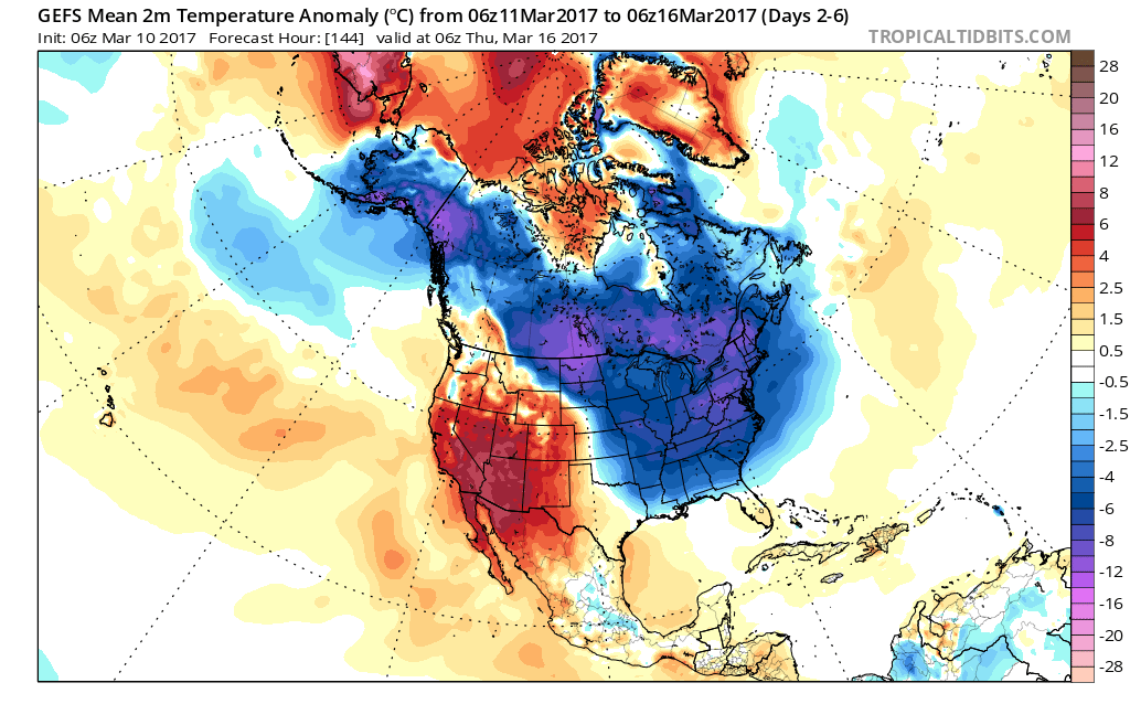
  • Bitterly cold air for March
  • St. Patrick’s Day showers

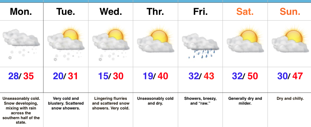
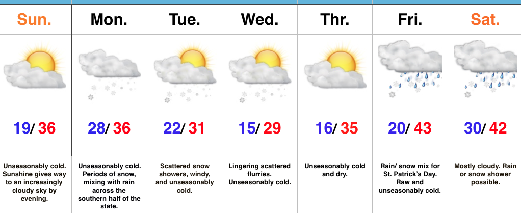
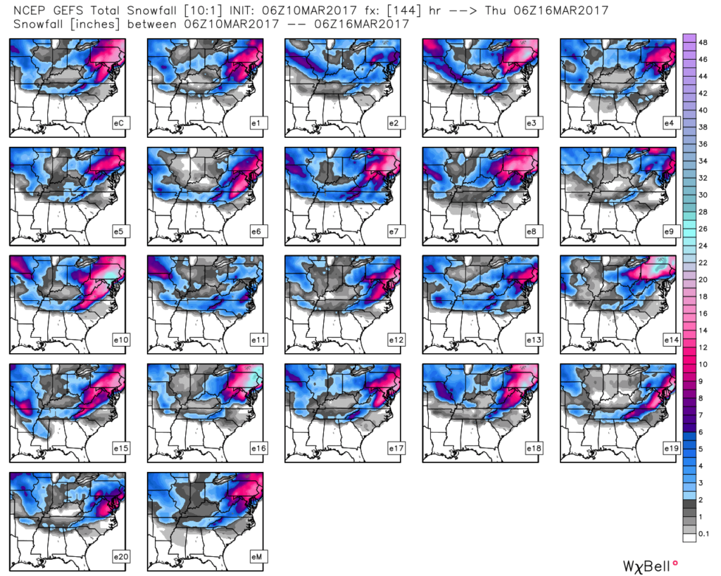
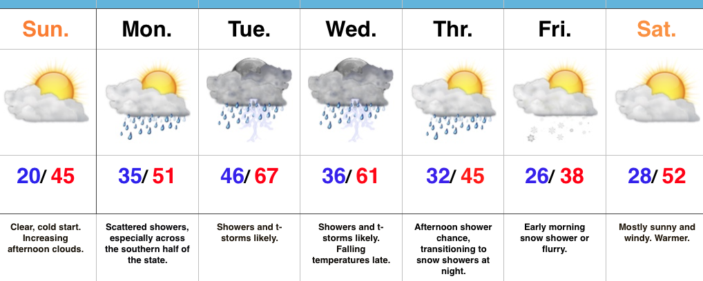
Snow Develops…Drier air is “eating away” at the snow shield as it attempts to advance eastward this morning.  Eventually, we’ll moisten the atmosphere up enough to allow snow to push into the greater Indianapolis region by late morning.  Snow will accumulate this morning, but marginal temperatures, that high March sun angle, and the fact most of the snow will be falling during the afternoon, we don’t anticipate accumulation issues this afternoon.  Reinforcing cold air will filter back into the region tonight and last through mid week.  With this late season arctic air, additional snow showers and embedded heavier squalls will continue.  With all of that said, we don’t have any changes to our ongoing accumulation forecast.  Expect an inch, or less, for the city, itself, increasing to 2″-5″ for north-central Indiana (where lake effect will add to the totals) for storm totals through Wednesday.

Dry conditions return late Wednesday and Thursday, but the cold will continue.  Our next storm system arrives on the scene St. Patrick’s Day and with blustery, chilly conditions in place, showers added to the mix will feature “raw” weather conditions.  As it stands now, we are going with a more optimistic approach for the weekend, including a dry forecast with increasing sunshine.  After the cold week ahead, we will have earned it!

Upcoming 7-Day Precipitation Forecast:

  • Snowfall: 1″ – 2″
  • Rainfall: 0.25″ – 0.50″

Permanent link to this article: https://indywx.com/a-wintry-week/

Work Week Opens Snowy…

Highlights:

  • Unseasonably cold
  • Snowy Monday
  • Cold week ahead

Sunny, But Cold…We may have sprung forward overnight, but Mother Nature can have a mind of her own.  Despite gaining an extra hour of daylight in the evening, temperatures will feel more like the dead of winter this week.  With the cold air comes snow chances, as well…

A frigid start to the day is at least accompanied by wall-to-wall sunshine, however, clouds will increase as we progress through the afternoon and evening hours.  Eventually those clouds will lower and thicken and give way to snow overspreading the state from west to east during the predawn hours Monday.  With marginally cold temperatures during the daytime Monday, we don’t anticipate big travel problems for most of central Indiana.  That said, if your travels take you north, prepare for slick travel as a “plowable” snow falls for our neighbors across northern Indiana.  As it stands now, we forecast generally an inch, or less, for the city, itself, Monday morning before melting occurs during the daytime.  As colder air pours into the state Monday evening, an additional dusting to coating is possible in spots through central Indiana as scattered snow showers and heavier bursts continue into midweek.  As mentioned, further north, several inches of snow (2″-5″) will fall for places like Lafayette, Kokomo, Marion and points north.  Perhaps an even bigger story will be the cold that follows the early-week snow.  Lows will fall into the middle teens for many central Indiana neighborhoods Wednesday and Thursday morning.

Looking ahead, confidence remains low in the late week forecast.  That fast-moving northwest flow aloft can (and will) wreck havoc on model solutions and fine tuning will be required as we progress through the week.

Upcoming 7-Day Precipitation Forecast:

  • Snowfall: 1″ – 3″
  • Rainfall: 0.25″ – 0.40″

Permanent link to this article: https://indywx.com/work-week-opens-snowy/

Winter Finally Shows Up…

Highlights:

  • Much colder than average
  • Snow prospects to open the week
  • Busy pattern continues

Locked In A Cold Pattern…The stretch of spring-like, unseasonably warm, conditions we enjoyed through most of February and to open March will be all but a distant memory once to this time next week.  A major reversal to a colder than normal pattern is now with us and will feature lows into the teens on a few nights over the upcoming week.

Additionally, we continue to highlight the fast-moving northwest flow aloft.  This kind of regime wrecks havoc on forecast models and, accordingly, we have lower than normal confidence in the specifics late in the work week.  Stay tuned.

Before we get to late week, we have a disturbance (that will eventually help feed a blockbuster Nor Easter) that will deliver snow as we open up the work week.  This time of year, snow intensity and time of day mean a world of difference between an accumulating event, or not.  Snow should overspread central Indiana before sunrise Monday and will likely accumulate before the higher sun angle takes over and lighter snowfall rates result in a lack of daytime accumulation.  As reinforcing cold air filters in Monday night, additional light accumulation will be possible in scattered heavier snow showers that will continue into Tuesday.  All-in-all, this doesn’t appear to be a huge event, but a few slick spots will be possible Monday morning before that higher March sun angle gets to work.  We’ll keep a close eye on things.

Moving forward, we’re confident on the overall colder than normal pattern that will continue into Saint Patrick’s Day, but, as mentioned above, fine tuning will be required with the potential of a late week storm system to contend with.

Upcoming 7-Day Precipitation Forecast:

  • Snowfall: 1″ – 3″
  • Rainfall: 0.25″ – 0.50″

Permanent link to this article: https://indywx.com/winter-finally-shows-up/

Extended Period Of Unseasonably Cold Air…

Today will begin a rather extended period of unseasonably chilly air that will grip the region.  It’s not until the latter portions of next week that we should begin to see slowly moderating temperatures.

The reason for this is a persistent trough setting up over the Great Lakes and eastern portions of the country.  From time to time, individual disturbances will come racing along in the fast northwest flow aloft and help to reinforce the cold and also create snow potential.

Forecast models continue to show an eastern trough into the middle parts of next week.


This is an impressively cold pattern for so late in the season.

This is the type pattern that will promote multiple nights in the teens over the upcoming week.  We forecast coldest nights to be Saturday night, Sunday night, Wednesday night, and Thursday night.  Each has the potential to send neighborhoods into the middle-upper teens.

As far as snow goes, we still are keeping an eye on the early stages of the work week.  We’ll fine tune things this weekend, but models continue to show energy diving southeast Monday that would help snow overspread the region during the day, continuing into Tuesday morning.  This time of year, snowfall rates and time of day means a world of difference between snow flying in the air, versus accumulating.  The potential is there for light accumulation Monday night as reinforcing cold air pours in.

Stay tuned!  Much more later!

Permanent link to this article: https://indywx.com/extended-period-of-unseasonably-cold-air/

Transitional Week Of Weather…

Highlights:

  • Warming back up
  • Storms around Tuesday-Wednesday
  • Colder late week
  • Windy warm-up next weekend

Don’t Blink…The second half of the weekend has gotten off to a frosty, but bright start!  Unfortunately, clouds will begin to increase this afternoon.  Thankfully, the increasing clouds won’t keep temperatures from getting a significant boost this afternoon compared to the frigid air of Saturday.

A few showers will scoot through the state Monday, but most of these will be confined to the southern third of Indiana and most neighborhoods should remain rain-free.  A more significant storm system will lift northeast Tuesday and this will provide better coverage of showers and thunderstorms Tuesday (especially late in the day) into Wednesday.  After a midnight high, temperatures will fall through the daytime hours Wednesday.

Another fast-moving, weak, weather maker will impact us Thursday evening into Friday morning.  Scattered showers Thursday PM will transition to light snow showers overnight into early Friday morning.  Friday will be chilly, but moderating conditions return as early as Saturday, along with a strong and gusty southwest flow by the afternoon!

Upcoming 7-Day Precipitation Forecast:

  • Snowfall: Trace – Dusting
  • Rainfall: 1.00″ – 1.25″

Permanent link to this article: https://indywx.com/transitional-week-of-weather/