Category: Arctic Cold

Accumulating Snow Friday; Dangerous Cold Develops Next Week…

Highlights:

  • Accumulating snow on the way
  • Frigid times remain
  • Dangerously cold next week

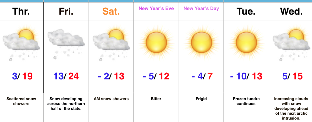
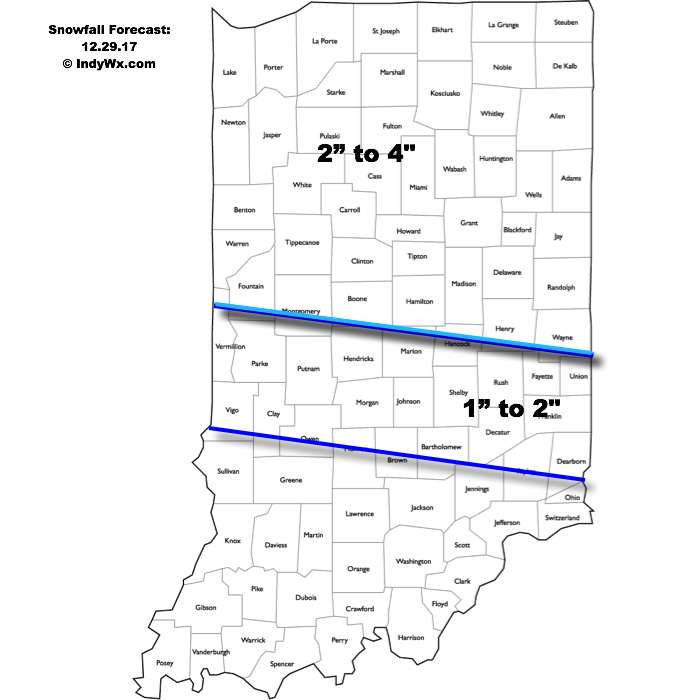
Snow And Major League Cold On Deck…A weak impulse of energy will track across the region today and will be just enough to ignite a couple of snow showers and scattered flurries.  For most, this won’t be a big deal.  A more impactful opportunity for accumulating snow will arrive Friday as a clipper system moves southeast.  Snow will develop late tonight across the Plains states before expanding in overall coverage and intensity as it pushes southeast into the Ohio Valley Friday.  With such cold air in place, snowfall ratios will be higher than the standard 10:1 and snow will quickly accumulate on roadways, making for slick travel Friday afternoon into the evening.  Here’s our current snowfall forecast for Friday:

Snow showers will taper off Saturday morning and give way to a blustery, bitter day.  Temperatures will fall through the day and wind chill values will turn dangerous Saturday afternoon and evening (10° to 20° below zero).  This arctic intrusion will set us up for a frigid close to 2017 and open to 2018.  In fact, we expect severely cold conditions early next week (double-digit below zero readings, including wind chill values approaching 30° below zero at times).  Plan and prepare now.

Upcoming 7-Day Precipitation Forecast:

  • Snowfall: 2″ to 4″
  • Rainfall:  0.00″

Permanent link to this article: https://indywx.com/accumulating-snow-friday-dangerous-cold-develops-next-week/

VIDEO: Early Accumulation Idea Friday Night-Saturday; Bitterly Cold Open To 2018…

You must be logged in to view this content. Click Here to become a member of IndyWX.com for full access.  Already a member of IndyWx.com All-Access?  Log-in here.

Permanent link to this article: https://indywx.com/video-early-accumulation-idea-friday-night-saturday-bitterly-cold-open-to-2018/

Snow Chances; Cold Only Grows Colder…

Highlights:

  • Frigid times
  • Snow chances return
  • Bitter open to 2018

Serious Cold…Arctic high pressure has settled over the region and combined with our snow cover to produce the coldest morning around these parts in a couple of years.  Some across central Indiana are awaking to double digit below zero readings.  Even the slightest breeze coupled with these bitterly cold readings creates dangerous conditions to spend time outdoors.

Cold is here to stay.  In fact, we’ll only grow more bitter next week.  If we can put snow down between now and then, there’s a good chance we’re not even cold enough early next week with forecast temperatures.  Speaking of snow, we’ll have to keep close tabs on impulses of upper level energy late tonight into Thursday for the potential of overachieving in the snowfall department (similar to what the I-70 corridor experienced Tuesday).  With arctic air in place, it doesn’t take much to get snow going.

We’re still expecting a more widespread snow event over the weekend.  We’re targeting Friday night into Saturday for light snow to overspread the region and this will setup a frigid close to the year and open to 2018.

Upcoming 7-Day Precipitation Forecast:

  • Snowfall: 1″ to 3″
  • Rainfall: 0.00″

Permanent link to this article: https://indywx.com/snow-chances-cold-only-grows-colder/

VIDEO: Bitterly Cold; Watching Saturday Closely…

You must be logged in to view this content. Click Here to become a member of IndyWX.com for full access.  Already a member of IndyWx.com All-Access?  Log-in here.

Permanent link to this article: https://indywx.com/video-bitterly-cold-watching-saturday-closely/

Cold Only Gets Colder…

Highlights:

  • Light snow chances
  • Frigid times
  • Bitter close to 2017

Heavy Winter Gear Required…First and foremost, we want to wish each and every one of you a very Merry Christmas and a continued blessed and safe holiday season.

The upcoming forecast period will be dominated by bitterly cold conditions.  At times, jabs of dangerous cold will penetrate into the Ohio Valley.  With arctic high pressure attempting to dominate the pattern, it’ll “out muscle” the potential of any sort of major widespread winter storm threats.  With that said, it won’t eliminate snow chances altogether and we must remain on our toes for the chances of a more impactful event over the weekend.

Beforehand, light scattered snow showers are possible late tonight into Tuesday morning as arctic reinforcements blow into town.  Two additional opportunities for snow will present themselves Thursday night into Friday morning, and, as mentioned above, just before the New Year.

Keep the heavy winter gear handy through the forecast period as Old Man Winter make his presence felt.

Upcoming 7-Day Precipitation Forecast:

  • Snowfall: 1″ to 3″
  • Rainfall: 0.00″

Permanent link to this article: https://indywx.com/cold-only-gets-colder/