VIDEO: Wintry Mess By Sunday Night; Don’t Put Us In The Winter’s Over Camp…
You must be logged in to view this content. Click Here to become a member of IndyWX.com for full access. Already a member of IndyWx.com All-Access? Log-in here.
You must be logged in to view this content. Click Here to become a member of IndyWX.com for full access. Already a member of IndyWx.com All-Access? Log-in here.
I. Bitter Cold: We’re adding another morning below zero to an already impressive (and growing) list of frigid lows this winter. Take a look at these morning lows in the…
You must be logged in to view this content. Click Here to become a member of IndyWX.com for full access. Already a member of IndyWx.com All-Access? Log-in here.
You must be logged in to view this content. Click Here to become a member of IndyWX.com for full access. Already a member of IndyWx.com All-Access? Log-in here.
 Highlights:
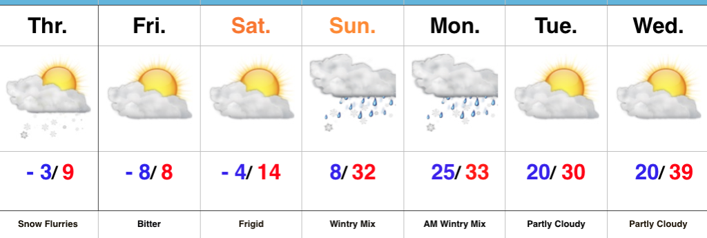
Brutal Cold Continues…A fresh batch of arctic air arrived into the Hoosier state last night. This will set the stage for an absolutely frigid close to the week. Wind chill values will periodically reach dangerous levels between now and Saturday morning. Additionally, we’ll add a few more mornings to the sub-zero club in what’s already an impressive list this winter.
Attention remains on a developing storm system that will impact our region Sunday into early Monday. We forecast a lowering and thickening cloud deck to arrive overnight Saturday into Sunday morning, followed by a wintry mix Sunday afternoon and evening. Messy wintry precipitation should continue into early Monday before precipitation departs to our east. Data, overall, has trended colder over the past 24 hours and would lead to more impact from snow and less ice. Stay tuned.
Drier times return early next week along with moderating conditions ahead of the next storm system that will approach late next week.
Upcoming 7-Day Precipitation Forecast:
Light snow will develop today along with gusty winds and reinforcing arctic air to follow. Attention remains on Sunday into Monday…
You must be logged in to view this content. Click Here to become a member of IndyWX.com for full access. Already a member of IndyWx.com All-Access? Log-in here.