Snow Develops Wednesday; Renewed Arctic Air…
Highlights:

  • Wednesday powder
  • Fresh batch of arctic air
  • Messy late weekend storm

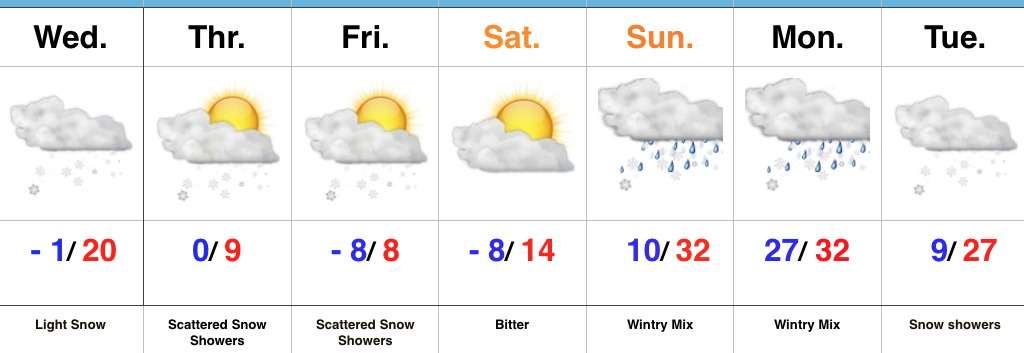
Snow Develops Wednesday Afternoon…Upper level energy will move across the region Wednesday and result in snow overspreading the northern half of the state (especially from Indianapolis and points north) during the afternoon and evening.  While snowfall amounts won’t be particularly impressive (generally 1″ or less), roads will likely get slick in relative quick fashion prior to the evening drive.  You’ll want to leave extra time on your evening commute home.  Otherwise, blowing and drifting snow will develop tomorrow night into Thursday as fresh arctic air pours into the area.

Attention will shift to lake effect snow across northeastern portions of the state Thursday before another ripple of energy drops southeast and sparks additional snow showers across central parts of the state to wrap up the work week.  Saturday will be dry and very cold.

Clouds will be on the increase overnight Saturday into Sunday morning and a mixed bag of precipitation will overspread the region Sunday PM.  We still have a few more days to watch things unfold, but concern remains for an icy cocktail of sleet and freezing rain after a potential initial burst of snow.  While warm air advection (WAA) will likely win out, we’re afraid it’ll be very difficult to warm the surface enough to prevent ice from becoming an issue Sunday afternoon into early Monday.  Cold air will sweep back in here Monday evening into Tuesday with snow showers and gusty winds.

Upcoming 7-Day Precipitation Forecast:

  • Snowfall: 1″ to 3″
  • Rainfall: 0.10″

Prolonged Bitterly Cold Pattern Rolls Along…

Highlights:

  • Dangerously cold pattern
  • Midweek snow showers
  • Messy weekend

Take The Cold Seriously…Dangerously cold conditions will continue this week.  With clear skies and a fresh snowpack, temperatures will quickly tumble tonight into double-digit below zero territory across most of central Indiana.  Add in even the slightest wind and wind chill values will plummet to 20 to 30 degrees below zero.  Limit time outside, check on your neighbors, and ensure your pets are cozy indoors, as well.

Next up on the agenda will be upper level energy moving southeast across the region Wednesday.  This will spark an area of snow showers with light accumulations for our hump day followed by reinforcing bitter cold to close out the week.  Additional upper level energy and some lake moisture will provide the chance of snow showers Friday in spots, as well.

A more widespread and significant storm system will arrive over the weekend.  Clouds will increase Saturday night into Sunday morning and a messy mixture of snow, sleet, and freezing rain will invade Sunday afternoon and evening.  Renewed bitterly cold, arctic air will plunge southeast early next week.  Additional sub-zero days are likely just beyond the forecast period…

Upcoming 7-Day Precipitation Forecast:

  • Snowfall: 1″ to 3″
  • Rainfall: 0.10″

VIDEO: Accumulating Snow For Some Overnight; Bitter Open To 2018…

Quick video update from the road this evening discussing another round of snow inbound tonight and a frigid open to 2018:

You must be logged in to view this content. Click Here to become a member of IndyWX.com for full access.  Already a member of IndyWx.com All-Access?  Log-in here.

Additional Snow Overnight; Dangerous Cold Grips The Region…

Highlights:

  • Blowing and drifting issues
  • Snow returns late tonight
  • Prolonged stretch of severe cold

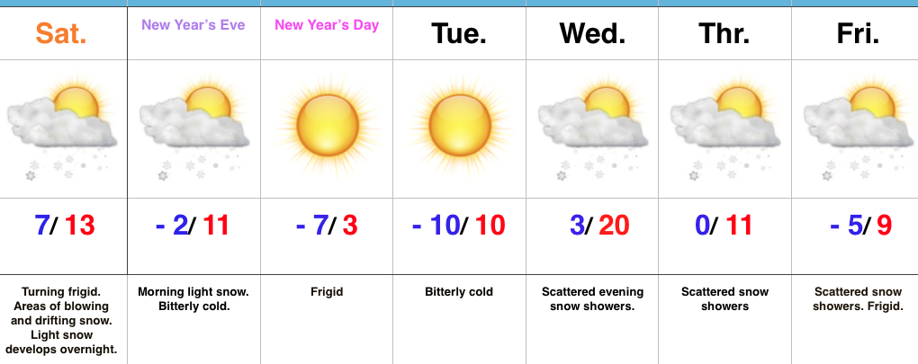
Bundle Up; Snow Returns Overnight…Yesterday’s snow event went as planned and many Hoosiers are waking up to several inches of powder this morning.  The winners yesterday stretched from Frankfort to Elwood to Winchester with a 6″ to 7″ band of snow.  All of that fresh snow will be blown and drifted about today with strong and gusty northwest winds.  If your travels take you into the open country, plan on significant blowing and drifting and leave extra time to reach your destination.

Additional upper level energy will scoot across the region late tonight into early Sunday and this will help kick up an area of light snow for central and southern portions of the state as we head into New Year’s Eve.  With the arctic air mass in place, don’t be surprised if we squeeze a quick inch out in spots.

Otherwise, the big story is the prolonged nature of this severe cold.  At times, wind chill values will drop to more than 30° below zero through early week.  Take the frigid conditions seriously.  Reinforcing arctic air will pour in here late next week and lead to scattered snow showers along with a bitter feel after slight midweek “moderation.”

Upcoming 7-Day Precipitation Forecast:

  • Snowfall: 1″ to 3″
  • Rainfall: 0.00″