Weekly #AGwx And Severe Weather Outlook…

Forecast Period: 06.02.19 through 06.09.19

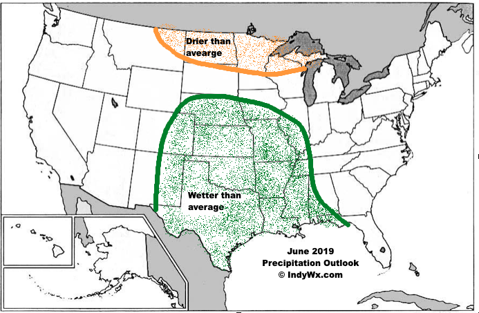
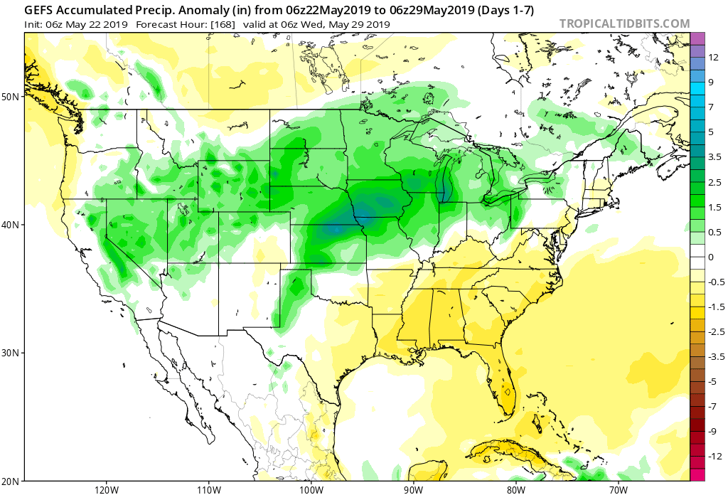
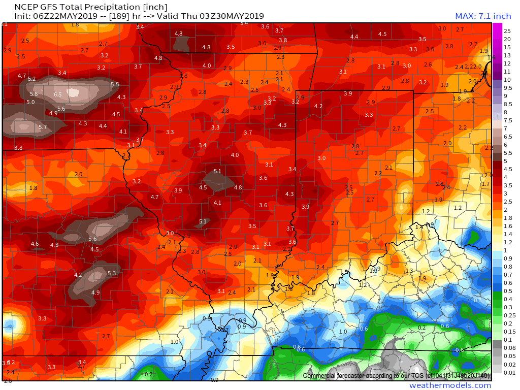
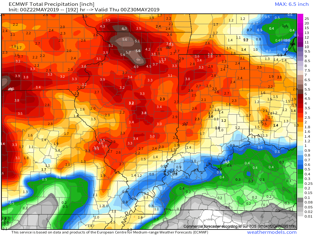
7-Day Precipitation: Rainfall is expected to run above average through the period.

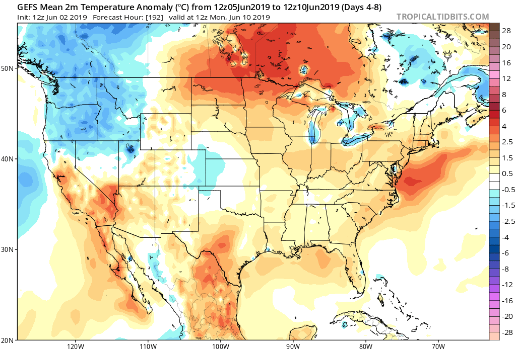
7-Day Temperatures: Above normal temperatures are expected through the period, mostly thanks to warmer than average overnight lows.

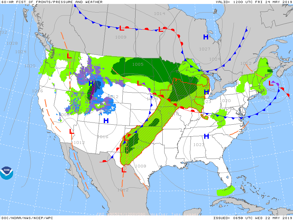
Severe Weather: We’ll remain quiet through early week before things begin to turn more active by midweek. The Storm Prediction Center is including the southern half of the region in a risk of severe weather by Wednesday (noted in the Day 4 Outlook below).

Summary: After a pleasant and quiet open to the period (today and Monday), thinks will begin to turn more active thereafter. Initially, it’ll take some time to “moisten” things up on Tuesday, but at the very least, light to moderate rain should work across central Indiana late Tuesday morning into the afternoon. Things will be fully saturated by Wednesday and periods of more concentrated rain, occasionally heavy, can be expected into the weekend. Unfortunately, guidance is in rather remarkable agreement of widespread 1.5″ to 2.5″ with locally heavier totals over the upcoming 7-day period.

June Outlook: Does The Wet Pattern Continue?

Averages for June are as follows:

  • Average Low: 62.1 (f)
  • Avearge High: 81.9 (f)
  • Average Rain: 4.25″
  • Average Snow: 0.00″

As we head to the 50-yard line of 2019 (already?!), we’re of the belief we’re looking at a cooler than normal month of June with close to average rainfall. Before we get into our reasoning of such, let’s look at a few snap shots of the latest data:

CFSv2

JMA

NMME

Though we can’t show it, the longer range European model paints a cool, wet picture from the south-central into the Plains and portions of the Northeast.

Given the analogs we’ve looked over with weak El Ninos along with similar MJO pulses, we’ve built a generally wet and cool June forecast nationally:

Ridging should support warmer than average conditions across the Southeast and Pacific Northwest, along with a rather widespread cooler than normal regime through the south-central Plains into the Great Lakes and New England. Unfortunately, we think wetter than normal conditions remain from the Delta into the central Plains. With that said, conditions seem more favorable for planting through a large portion of the OHV region.

Prolonged Unsettled Stretch Of Weather…

Yesterday was only the beginning of a renewed prolonged stretch of unsettled and stormy weather. A series of fronts will make a move towards the OHV only to stall out and lift north back as a warm front over the upcoming 7-day period. The end result? An extended stretch of wet, stormy conditions.

Rainfall amounts will run above normal over the upcoming 7-day period.

Get used to the setup above with a stalled front nearby and waves of low pressure moving along the associated boundaries from time to time. As these ripples of energy scoot along the front, more enhanced showers and thunderstorms can be expected.

It’s still tough from this distance to say with certainty which day(s) will offer up the most widespread shower and thunderstorm coverage in this pattern, but we continue to lean towards Saturday into Sunday. Stay tuned.

Models agree on widespread 1.5″ to 2.5″ rainfall totals over the upcoming week with locally heavier amounts.

Conditions will also return to a warmer than normal theme into the middle of next week. At times, conditions will become oppressive (depending on which side of the front you find yourself on). If heading to the track, ensure you have means to remain cool and pack the rain gear just to be safe!

More later tonight on the long range, including a video recap of our Summer Outlook.

More Reason To Be Concerned With Overall Wet Pattern Long-Term…

The month of May, though still active at times, has provided drier than normal conditions across a good chunk of the state. Officially, we’re (IND) running around half an inch below normal, month-to-date.

Precipitation departures from normal over the past week and month-to-date can be found below. Note the drier conditions, especially across the southern half of the state. Meanwhile, northern Indiana remains wetter then normal.

Unfortunately, a return of wet times looks likely. Latest data into the forecast office this evening, including the European Weeklies hot off the press, would suggest above normal rainfall can be expected for late-May, June, and a good portion of the summer for that matter.

There’s reason to believe this data is correct when we look at the latest MJO forecast. Note the MJO is expected to roll out of Phase 1 and into Phase 2 late-May and early-June- and potentially Phase 3 a bit later. Not only does this suggest the wet regime should pick back up in earnest across central Indiana, but also that the pattern will trend cooler (after what will be a hot and sultry stretch the 2nd half of this week into early portions of Week 2. The latest European Weeklies go right to this look for June, including a cooler than normal month overall.

Updated model data tonight still says a weak El Nino will continue through summer and this, too, argues for a wetter and cooler than average flavor to the 2019 Summer.