March To-Date And Looking Ahead…

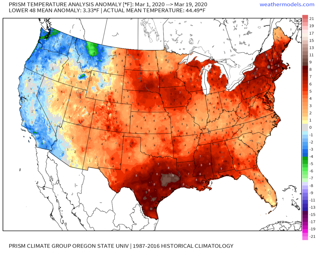
March to-date is running warmer and wetter than average across not only central Indiana, but a good chunk of the central and eastern part of the country.

Officially, Indianapolis is running 5.3° above normal, month-to-date.

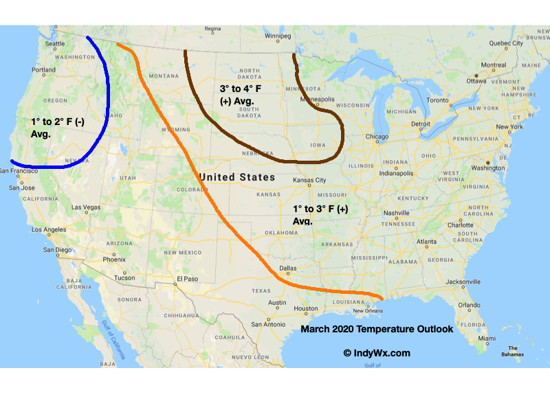
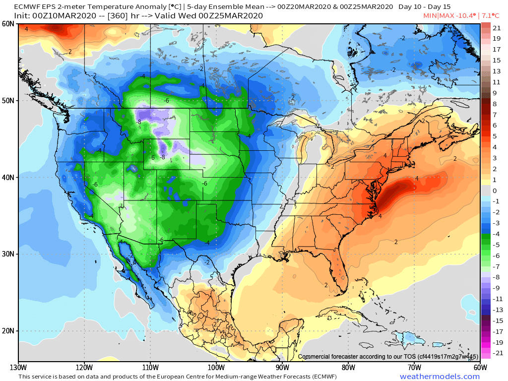
For comparative purposes, our March Temperature Outlook is above. It’ll be interesting to see how everything shakes out by month’s end.

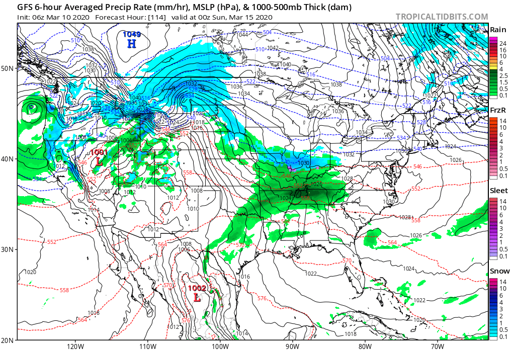
We anticipated a wet month, as well, into the middle MS Valley into the Ohio Valley, and eastern Lakes/ Northeast.

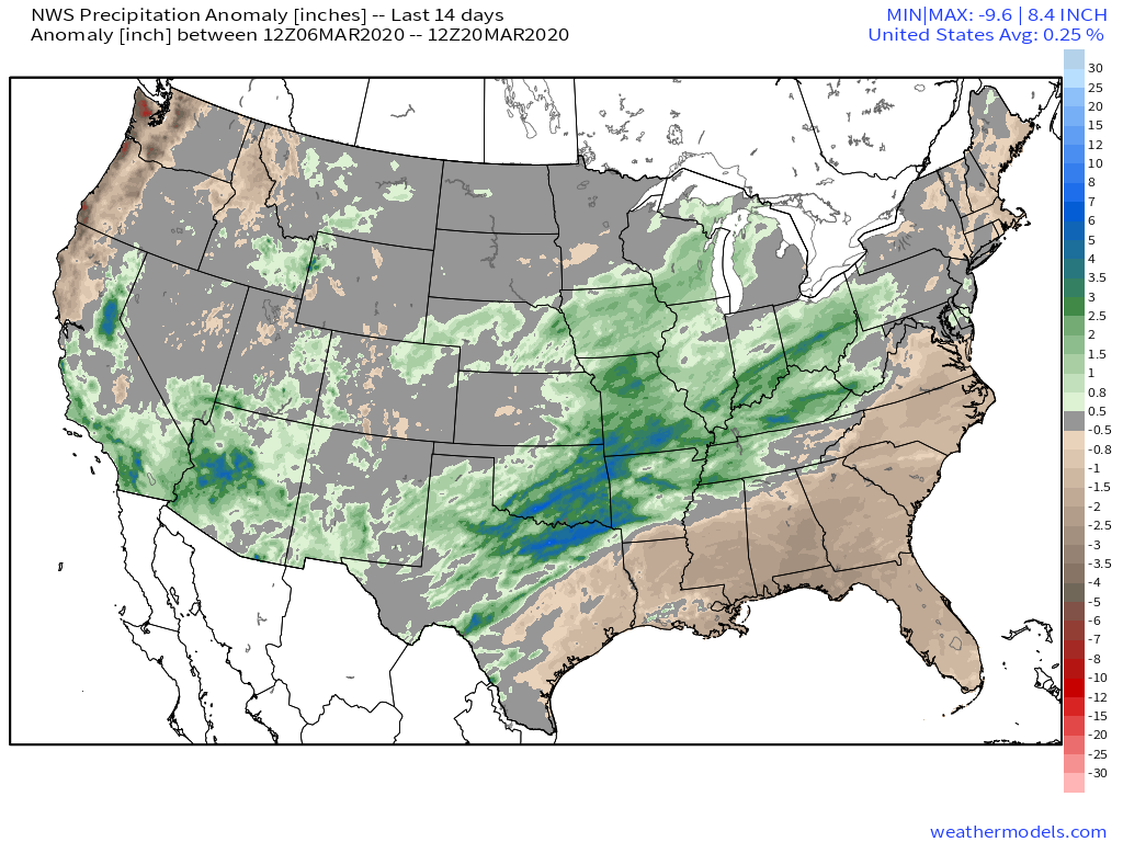
Indianapolis is running a little more than 1″ above normal in the rainfall department, and this will grow larger as we progress through the next (10) days.

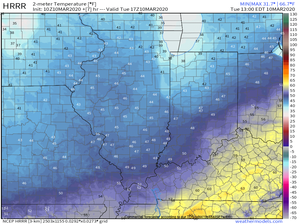
This upcoming week, alone, we expect storm systems to deliver rain Sunday PM, Tuesday PM, and again late Thursday into Friday. Widespread central Indiana rainfall totals are currently pegged between 1″ and 1.5″, but given the pattern, it wouldn’t surprise me to see those numbers increase as we go forward. Thankfully, there aren’t any storms on the immediate horizon that look to be big severe weather producers, locally.

The remainder of March looks wetter than normal from the TN Valley, into the Ohio Valley and Northeast.

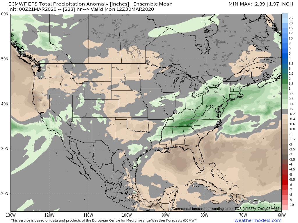
Despite this weekend’s chill, the balance of what’s left in the month should run well above average across the eastern half of the country.

More on what we think April will provide a bit later…

Very Active Pattern Looms For Mid And Late March…

Before we get into the longer range weather pattern, rain this morning has been locally heavy in spots. Moving forward today, that rain will push east of the state and we’ll turn cooler. Temperatures will settle into the middle to upper 40s this afternoon across central Indiana.

Another couple of weak systems will scoot through the area as we push through the remainder of the work week. The first, tomorrow, will impact areas primarily to our north, however, a cold front will sweep through the state Thursday night and early Friday with light rain and an abrupt wind shift to the northwest. Rainfall amounts with the passage of this cold front should average only between a trace and 0.05″.

A third system will push east across the TN Valley Saturday into early Sunday. With marginally cold air in place across the Ohio Valley, precipitation may transition to wet snow or a mix of rain and snow along the I-70 corridor during this time frame. The northward extent of the precipitation shield is in question and we’ll have to keep a close eye on this system over the next couple of days.

As we look longer term, a tight thermal gradient is expected to setup shop across our region. This will force a cold pattern across the west with eastern seaboard warmth. We’ll be in that “back and forth” battle zone of sorts, locally.

What this will also do is help assist in a hyper storm track through the MS River Valley and Ohio Valley. Above to well above average precipitation is expected during the middle and latter part of March across our region.

Unfortunately, local landscaping companies, turf management, farmers, and others with ag interests are likely to experience delays as we move through the 2nd half of March and into early April.

Harvest ’19: Tracking Another Significant Storm This Week…

*Starting November 1st, our weekly agriculture and harvest updates will transition to weekly winter storm outlooks. We’ll maintain a lot of the feedback y’all have provided with the new weekly winter products. Come next growing season, the weekly agriculture and severe weather updates will return.

Forecast Period: 10.27.19 through 11.03.19

7-Day Precipitation: Average average precipitation is expected through the period.

7-Day Temperatures: Once the forecast period is said and done, below average temperatures can be expected, overall.

Severe Weather: Organized severe weather isn’t expected during the period.

Frost/ Freeze: The first frost and freeze of the fall season will likely take place next weekend across portions of the Deep South.

Drought Monitor: The latest drought monitor (taken before Friday and Saturday’s rain) shows abnormally dry/ drought conditions in place across southern IN into central OH. Thankfully, a long-term drought isn’t expected here. The pattern not only at present, but throughout the upcoming winter will feature plentiful precipitation, erasing any of the abnormally dry conditions that are currently in place.

Summary: We’re monitoring a couple of storm systems this week. The first system will scoot by to our northwest with a band of rain and snow from KS, IA, and into IL and WI during the early part of the work week. A second, stronger system will impact the region Wednesday into Friday. Another wind-driven rain will be the result, locally, Wednesday into Thursday before sharply colder air arrives to close the work week. The air will grow cold enough to support the potential of flurries or scattered snow showers late Thursday night into Friday. The first official freeze of the season is likely next weekend. Upcoming 7-day rainfall totals are expected to fall in the 0.75″ to 1.25″ range for most of immediate central Indiana.

Harvest ’19: Severe Storms For Southern IN Tomorrow? Precipitation And Temperature Trends Over The Upcoming 7-Days…

*Starting November 1st, our weekly agriculture and harvest updates will transition to weekly winter storm outlooks. We’ll maintain a lot of the feedback y’all have provided with the new weekly winter products. Come next growing season, the weekly agriculture and severe weather updates will return.

Forecast Period: 10.20.19 through 10.27.19

7-Day Precipitation: Average to slightly above average precipitation is expected through the period.

7-Day Temperatures: Below average temperatures are expected through the period.

Severe Weather: We’re monitoring the potential of a few strong to severe thunderstorms- mostly across southern portions of the state Monday afternoon and evening. The biggest concern has to do with the potential of damaging straight line winds with embedded cells that form directly ahead of the cold front tomorrow evening.

Frost/ Freeze: While most of the immediate region has already dealt with multiple hard frosts, frost and freeze conditions will expand south over the upcoming week. The coldest morning, overall, appears to be Saturday with the potential of a freeze extending south into the Ozarks and northern TN Valley.

Drought Monitor: The southern and eastern portion of the region remains in abnormally dry or drought conditions. The pattern ahead longer term does look favorable to erase a lot, if not all, of these dry/ droughty areas before the end of the year.

Summary: The upcoming 7-day period will feature two primary storm systems. The first arrives Monday with showers and thunderstorms. We’ll continue to monitor the potential of strong-severe storms across southern portions of Indiana tomorrow PM and update accordingly later this evening. The second system will be a colder feature and thunderstorms aren’t anticipated with Friday’s storm system. The pattern still seems poised to produce the coldest air so far this season just beyond the forecast period. Overall, upcoming 7-day rainfall totals are expected to range between 0.50″ and 0.75″ for most of immediate central Indiana.