Weekly #AGwx And #Severe Weather Outlook…

I. Tropics claim headlines this week.

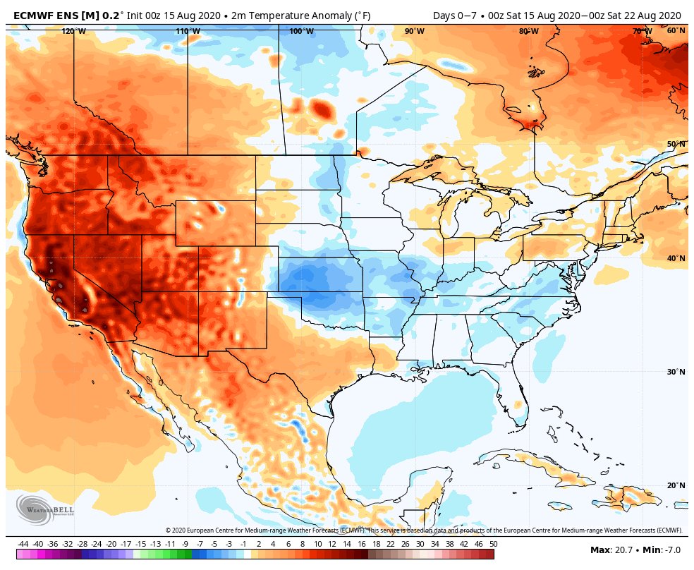
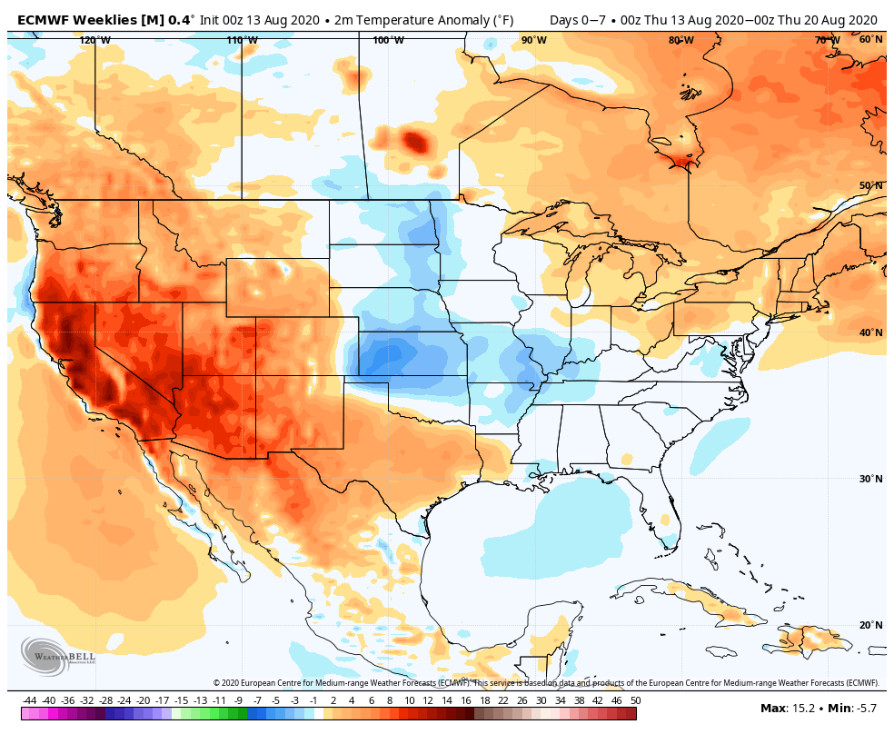
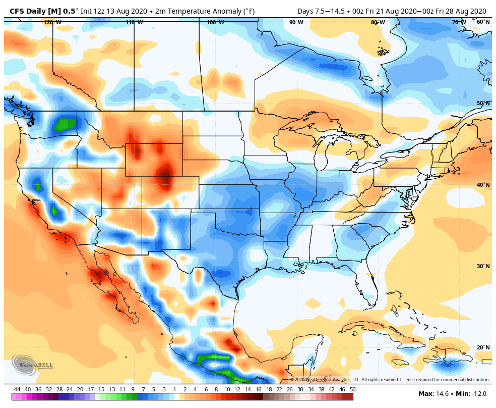
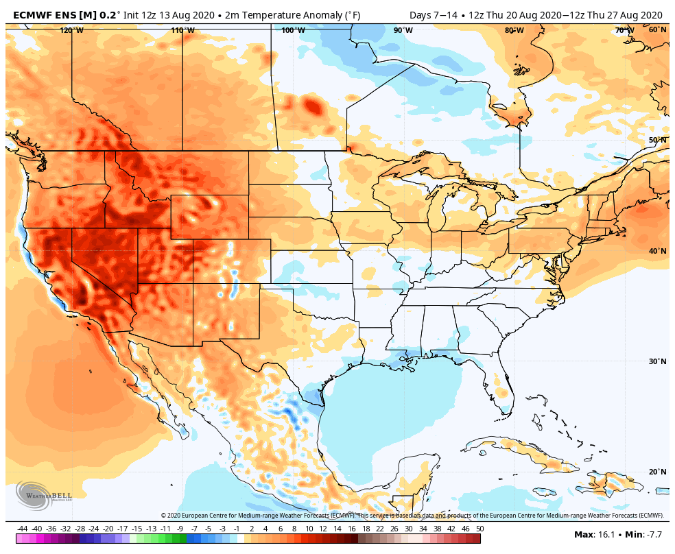
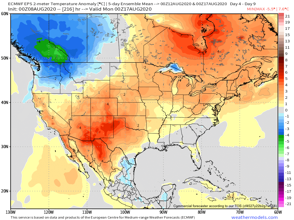
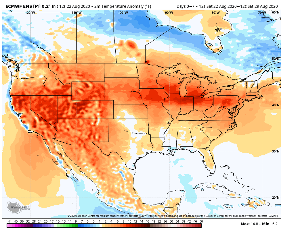
II. Summer-like temperatures and humidity returns.

Coast-to-coast warmer than normal temperatures can be expected this week, with (2) areas of greatest anomalies: West and lower Great Lakes.
The central and western Gulf into the Deep South and TN Valley will see a flood threat this week as remnant tropical moisture moves inland.
We expect between 0.75″ and 1.5″ of rain this week for most of central Indiana.

Forecast Period: 08.22.20 through 08.29.20

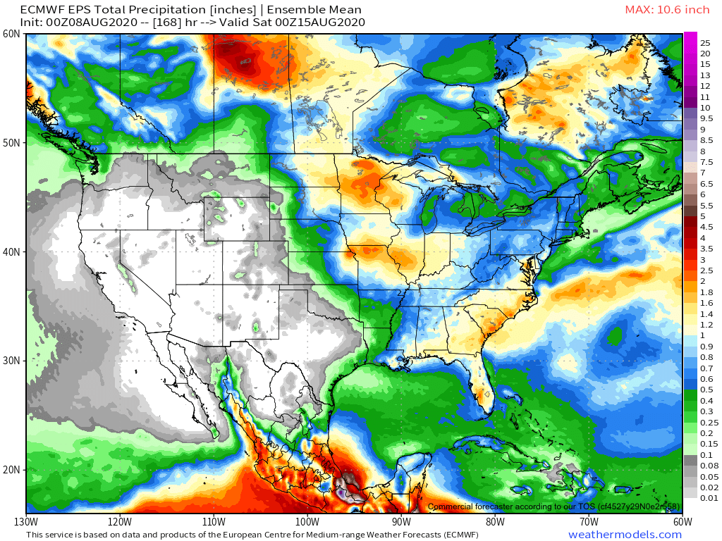
A historic tropical event is likely to impact the Gulf of Mexico this week as not one, but two named tropical systems (likely both hurricanes) track north, northwest and target the central and western Gulf Coast. While additional fluctuations in the ultimate track and subsequent point of landfall can be expected over the next couple of days, confidence is increasing on the likelihood of 2 hurricanes making landfall within 36-48 hours of each other somewhere from the MS coast to the LA and TX coast. This won’t only be a coastal issue, but quickly grow into a big inland flood situation for the lower MS Valley and into the TN Valley as we get into the middle and latter parts of the week.

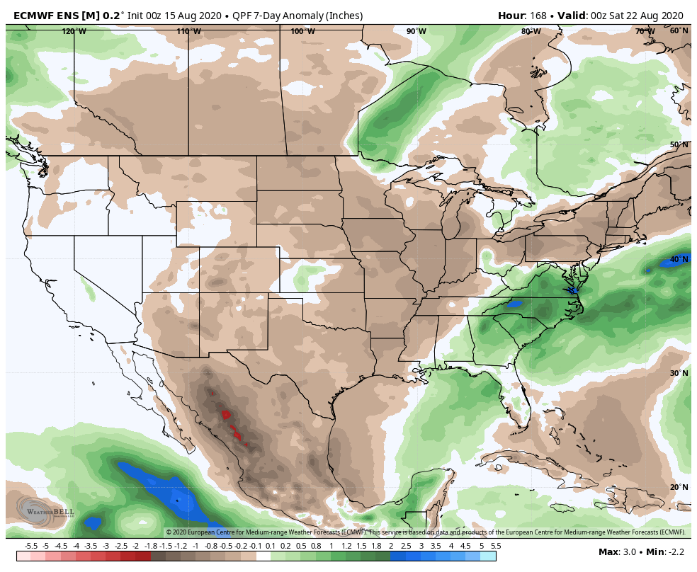
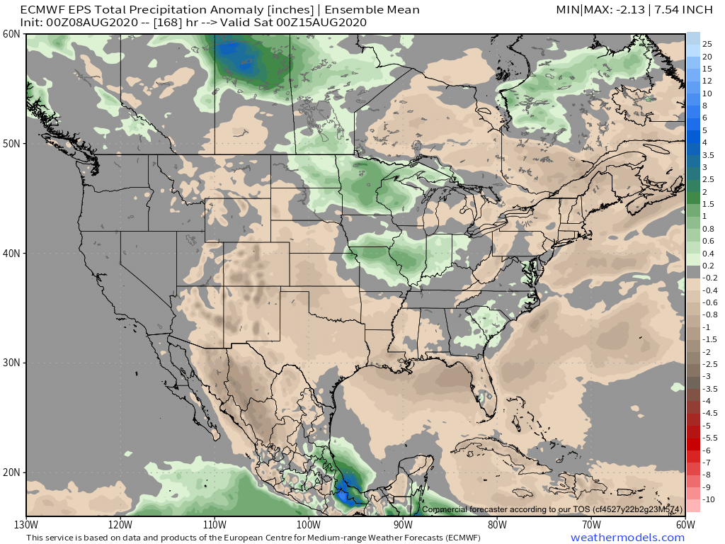
Back home, a much more typical summer-like regime can be expected this week, including a return of heat and humidity. While splash and dash coverage of storms is expected Sunday evening into Monday, most of the upcoming week looks rain-free, at least until late week. That’s when a stronger cold front will take aim on the region and increase shower and thunderstorm chances Thursday into Friday. To add further complexity into the equation, we’ll also have to monitor the remnant tropical moisture moving north, as it’s still possible some of this moisture gets entangled with the cold front. Whether or not this is the case or not is yet to be seen and will be the cause of great whaling and gnashing of teeth this week. Regardless, unlike with some tropical remnants, the upper pattern supports a fairly quick movement of the remnants once to midweek, so that would greatly limit flooding potential up this far north.

The early call on next weekend is for a drier regime to begin building in.

Weekly #AGwx And #Severe Weather Outlook…

I. Widespread area of below normal rainfall from the Plains into the Ohio Valley.

II. Anomalous heat bakes the West.

Widespread well above normal temperatures will bake the West this week while we remain seasonable to slightly below normal, locally.
Heavy, tropical downpours will impact the Southeast while the majority of the remainder of the country will remain on the drier side of normal.
7-day rainfall totals should only add up to between 0.10″ and 0.25″ for central Indiana.
The week isn’t expected to produce widespread, organized severe weather across our neck of the woods. Better chances of severe weather can be expected today across the upper Midwest and high plains.

Forecast Period: 08.15.20 through 08.22.20

Relatively quiet weather conditions can be expected across our region this week. A cold front will slip through the area Sunday and will offer up the best chance of getting precipitation throughout the upcoming 7-day period. Even this won’t be anything to get excited about, but there will be a broken band of showers and embedded thunder that scoots across the state for the 2nd half of the weekend as the cold front moves southeast. (Additionally, if viewing from northwest or west-central Indiana, you will have the chance of a passing thunderstorm later this evening as the front inches closer). Thereafter, generally dry and seasonable to slightly below normal temperatures can be expected as high pressure dominates. The one potential “interruption” to what will otherwise be a dry forecast has to do with a 2nd frontal boundary that will make a run at the region mid-to-late week. For now, we’re not excited about precipitation chances, but “isolated” shower coverage is possible by Thursday into Friday. Overall, we’re only expecting most central Indiana rain gauges to accumulate between 0.10″ and 0.25″ for the entire period.

Long Range Update: Closing Out August…

With a little over 2 weeks to go in meteorological summer, model data disagrees in the way the month- and season ends. That is, after the upcoming week where the consensus is cooler and drier than normal (we agree, as well). Let’s take a look at the data:

European Weeklies

Week 1

CFSv2

Week 1

GEFS

Week 1

EPS

Week 1

JMA

Week 1

The American data and JMA Weeklies are coolest (compared to the European), but compared to Weeks 2 and 3, there’s better consensus. The initial week is also looking drier than normal- especially after a “smattering” of storms tomorrow and Saturday.

Week 1 Precipitation anomalies- JMA Weeklies
Week 1 Precipitation anomalies- European ensemble

Let’s now take a look at Week 2:

European Weeklies

Week 2

CFSv2

Week 2

GEFS

Week 2

EPS

Week 2

JMA

Week 2

This is where our idea begins to pivot more towards the JMA Weeklies and European data (warmer look). The reason primarily has to do with the MJO moving back into Phase 8 during this time period.

This is a warm phase in August.

Furthermore, the PNA ‘mean’ is forecast to trend off the positive “mountain” (that will help drive the cooler pattern for the upcoming week) and more towards neutral.

Phase 1 is also a warmer look for our part of the country and that’s the way we’re leaning for the last week of the month (despite the very cool CFSv2).

While not overly warm, we think the JMA has the best handle on the temperature pattern in the Week 3 timeframe, locally (seasonable to slightly above normal).

The pattern should also begin to trend wetter during this time period:

This matches up with Phase 1 of the Madden Julian oscillation:

So, to summarize, after a cool and dry period next week, we anticipate the pattern to trend warmer (more seasonable) and wetter to close the month and head into early September. One other item of note is that the tropics should really begin to heat back up during this period, as well. Of course, as is the case from time to time, that can be a wild card from a precipitation perspective. The Gulf of Mexico (GOM) looks particularly busy late August through late September, but there’s simply no way to get more specific from this distance, including potential inland impacts. It’s worth keeping a close eye though.

Before we leave, the latest JAMSTEC seasonal data updated this morning and features a “torch” of a fall, along with a warm, wet winter, locally. That southeast ridge will have to be dealt with this winter. While still early, the early lean is for a warm start to winter (including holiday season). While there are some ingredients that may keep things more interesting than what they could be otherwise, from at least this point, this doesn’t appear as if it’ll be an “exciting” winter for lovers of snow and cold. Much more later- and again, we still have a long way to go…

Weekly #AGwx And #Severe Weather Outlook…

I. Warmer and more humid air builds northeast through the period.

II. Rain and storms return.

While excessive heat isn’t expected, a much warmer and more humid pattern will emerge (compared to late) through the forecast period.
Above average rainfall is expected from the upper Midwest into the Ohio Valley.
Clusters of storms should lead to between 1” and 2” of rain for central Indiana by next Saturday morning. There will be locally heavier amounts.
Storm complexes will have embedded strong to severe thunderstorms this week. Biggest concern will be the potential of damaging straight line winds.

Forecast Period: 08.08.20 through 08.15.20

While we still have one more day of relatively low humidity, that will begin to change for the second half of the weekend. Temperatures will climb to seasonal and above normal levels this week as well. In short, after an unusually refreshing open to August, true late-summer conditions will build back into the region. Rain and storm chances will also increase substantially throughout the week. Some storm complexes will include heavy rain and embedded stronger storms. From this distance it’s hard to pinpoint what day will have the best chance of storms, but agriculture, turf management, and anyone with outdoor plans should prepare for multiple days with weather impacts through the upcoming week. Given the nature of this setup, some communities will likely deal with excessive rain totals by this time next week (unfortunately the pattern still looks wet beyond the period), with widespread 1” to 2” totals across the board.

Long Range Update: Changes Loom For Mid-Late August…

August has opened unseasonably cool and refreshing. There’s even been a hint of fall to the air the past couple of mornings. The refreshing feel will continue as we wrap up the week, but changes for the warmer and muggier loom.

The first (5) days of the month are running more than 5° below normal for Indianapolis.

Even before we look at the respective model data for mid-late August, it’s important to note we’re basing our long range forecast (this was a byproduct in building our August Outlook) on the MJO heading into Phases 8 and 1 over the next couple of weeks. These are considerably warmer and wetter phases for our region and that fits our idea. Perhaps of interest beyond the next couple of weeks is that the amplitude should continue into Phases 2-3 as we wrap the month and head into early September. That, combined with other factors, will likely serve to re-ignite the tropics to close the month and head into the 1st month of meteorological fall.

Note the warmer, wetter look associated with Phases 8 and 1:

The CFSv2 is following this trend in the latest Weeks 1-2 outlook:

The latest European Weeklies are also in and paint a similar picture:

The JMA Weeklies follow a like path, but not as wet as we believe Week 2 will be:

The thinking here is that while we’re certain to warm in the mid-late month period, we still aren’t talking about any sort of prolonged periods of excessive heat. The more active upper air pattern will result in multiple frontal boundaries and disturbances scooting through the region to serve up more widespread, organized rain and storm chances. In short, we feel good about the rebound coming that should result in a month, as a whole, close to average in the temperature department with above to well above normal rainfall.