Heavy Rain Axis Shifts North…

Updated 02.27.21 @ 3a

While we’re dealing with areas of light rain early this morning, most of our Saturday will be precipitation-free. That will all begin to chance during the overnight and predawn hours Sunday. Computer model guidance has begun to trend north with the heavy rain axis during this time frame. Southern portions of the state will still get in on the heavy rain show, but it now appears as if there will be a window for heavy rain across more of central Indiana in the 2a-9a window Sunday.

Forecast radar 5a Sunday
Rainfall totals through noon Sunday.

More later this morning in our video update.

Another Problem Brought On By Dry Ground…

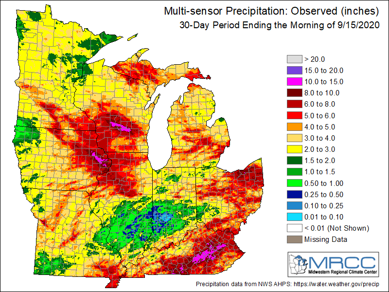
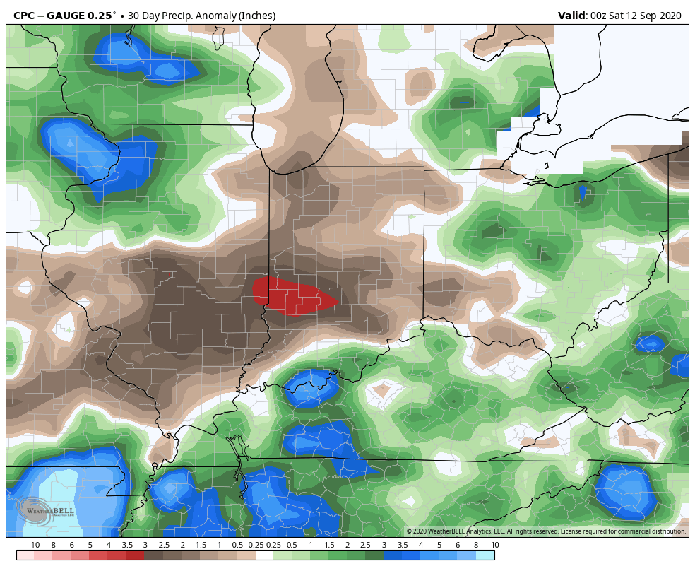
The upcoming (10) days will offer little, if any, relief from the recent dry stretch. Note the expanding (albeit still localized in the grand scheme of things) area of dry over the past (30) days:

Some areas from south-central IL into central IN have only seen 0.10” to 0.50” over the past month.

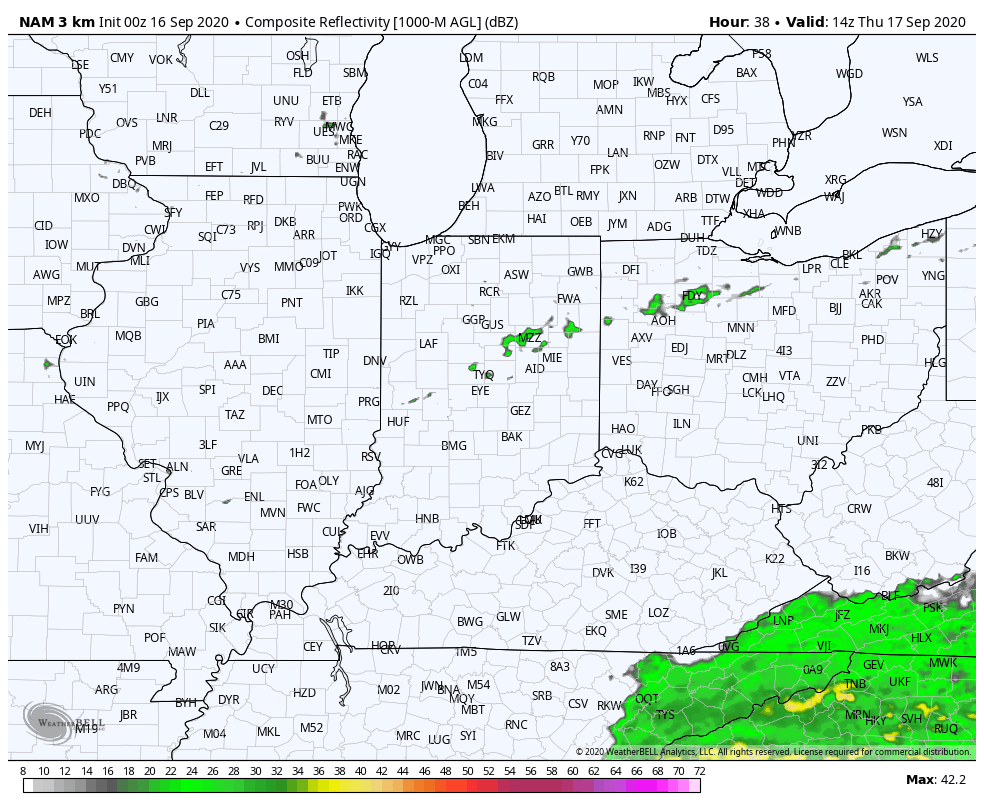
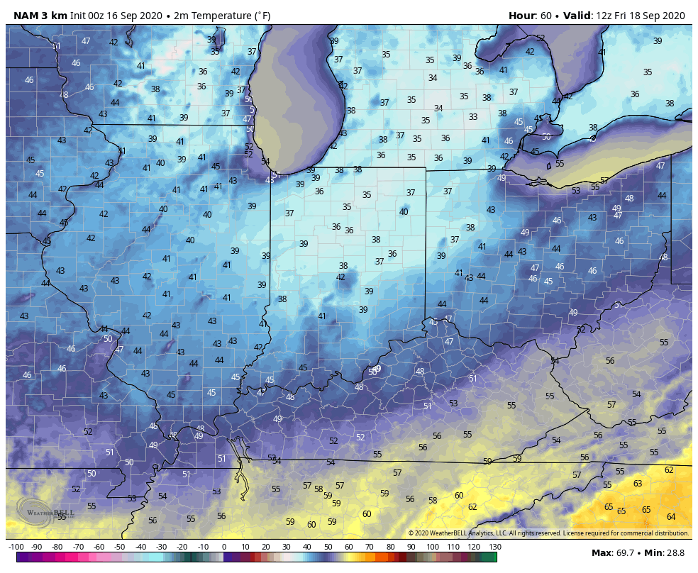
While a cold front will slip through the state Thursday, only isolated, weak showers are expected. Most will avoid any rain (best chance of seeing a passing shower will be across northern IN but even these won’t amount to much).

Of more interest will be the true jab of fall air behind the boundary. The dry ground will aid in allowing temperatures to fall to lower levels than if we had recently been dealing with wet conditions. In fact, outlying areas across central and northern parts of the state can expect the first frost of the season (2-3 weeks earlier than average) this weekend into early next week with overnight lows falling into the mid to upper 30s.

Quick follow up: Many have asked, and we are safe along the beaches of Walton Co. here in the Florida panhandle. Sally (now a category 2, 100 MPH hurricane) is making landfall near Gulf Shores, AL- 150 mi. to our west. We’ve accumulated over 15” of rain since 12a Tuesday and torrential downpours continue. Early this morning winds have gusted over 60 MPH and water spouts have been observed just off the coast of where we’re staying. As long as we maintain power, we’ll have a fresh video post later today.

Extended Dry Period…

IND is now running more than 1.2″ below normal for the month and this is coming off a dry finish to August.

Note the localized, but significant, area of bone dry conditions extending east from eastern IL across central Indiana (while surrounding areas have cashed in on significant rains over the past 30 days):

The upcoming 7-days won’t offer up much relief from the dry conditions as high pressure dominates. Even the mid-to-late week cold front should pass through the region mostly dry.

Most guidance only drops between a trace and 0.10″ of rain on central Indiana over the next (10) days as the dry pattern rolls along. The GFS and European ensemble products highlight the dry regime well:

Ironically, the overall pattern should shift in dramatic fashion as autumn matures and heads into winter. We still expect an about face late autumn as the wet anomalies paint themselves across our region as the southeast turns dry, thanks to the La Nina pattern…

Weekly #AGwx And #Severe Weather Outlook…

I. Tracking multiple cold fronts this week.

II. Pattern transitions cooler than normal as we move through the 1st (10) days of September.

Temperatures will run close to seasonal norms up until Labor Day weekend before trending cooler than normal.
Precipitation in the week ahead will run slightly above average, locally. Most of the West will remain drier than normal, with the Deep South also dry. Wettest anomalies can be expected from the TN Valley into the Northeast.
We forecast between 0.50” to 1” of rain across central Indiana through the 7-day forecast period.

Forecast Period: 08.29.20 through 09.05.20

As we flip the page from meteorological summer to fall, a more active pattern can be expected, locally. Of course we already had one cold front sweep through the region this morning and we’re tracking 3 additional fronts between now and Labor Day. The 2nd front will move through midweek with scattered showers and storms Tuesday afternoon and Wednesday. The 3rd front will arrive Friday with yet another scheduled for a passage Labor Day night. Each front will provide an enhanced chance of showers and embedded thunder, but washouts aren’t anticipated any of the days through the upcoming week. Temperatures will run near seasonal norms before trending much cooler behind the Labor Day front (late September or early October like temperatures).