Category: AG Report

Weekly #AGwx And Severe Weather Outlook…

Updated 03.07.21 @ 8:48a

I. Unseasonably mild open to the week

II. Heavy rain/ potential flooding threat looms late week across OHV

Widespread above normal temperatures can be expected this week. Only exception to this will be across the West and far Southeast.
Above normal precipitation will target the MO Valley and into the western OHV.
We expect between 1″ and 2″ for most of IN in the week ahead.
Widespread significant drought continues across the West, especially Southwest/ Four-Corners region.

Forecast period: 03.07.21 through 03.14.21

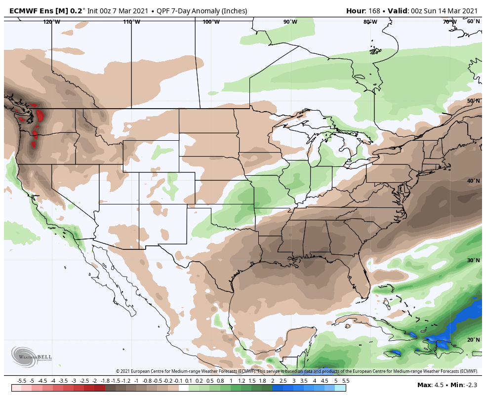
While our weather will remain “eerily quiet” to open this forecast period, significant changes await on deck by the 2nd half of the week. These changes will be ushered in from a cold front that will lead to increasing shower (maybe even embedded t-storm) chances Thursday before rain becomes widespread Thursday night into Friday. The GFS and European computer models begin to disagree on the evolution of things next weekend. The GFS stalls the front just to our south before a surface wave of low pressure rides along the boundary over the Saturday-Sunday period. Meanwhile, the European shoves the front off to the south in a quicker fashion, allowing for a drier weekend. We’ll need to keep a close eye on things and update in the days ahead. Should the GFS idea be correct, a flood threat would ensue, including weekend rainfall totals of several inches. We’re not ready to jump on the excessive rainfall idea yet, due to the differences in the handling of the frontal boundary/ associated surface wave, but will keep a very close eye on things. Stay tuned.

Permanent link to this article: https://indywx.com/weekly-agwx-and-severe-weather-outlook-22/

Weekly #AGwx And Severe Weather Outlook…

Updated 02.28.21 @ 7:25a

Headlines:

I. Heavy rain threat targets TN River Valley

II. Eastern, Southeastern regions cool late in the period

Overall, over the upcoming 7-day period, above normal temperatures are expected from the northern Plains into the Southeast, including OHV.
Precipitation is expected to run above normal across the Southeast, TN Valley, and lower OHV.
Rainfall should run between 0.75″ and 1.25″ for central IN over the upcoming 7-days.
There is a threat of severe weather today from the Ark-la-tex region into the western TN Valley.
Widespread significant drought continues across the West, especially Southwest/ Four-Corners region.

Forecast period: 02.28.21 through 03.07.21

The short-term will be dominated by a the wet (and stormy for some) time of things from the OH Valley, but more so centered in the TN River Valley. Eventually the associated frontal boundary will sweep into the Southeast region early in the work week before stalling out and serving as the focal point for additional storm systems mid and late week. The first of these systems will scoot from the southern Plains east into the Southeast in the Monday through Wednesday time period with additional opportunities for heavy rain and local severe weather. We’ll watch for another suppressed system late in the week that will likely take a similar route in the Thursday-Saturday timeframe.

From a central Indiana standpoint, best rain chances out of the entire period are in front of us now. Things should dry out considerably through the balance of the upcoming work week given the overall pattern.

Permanent link to this article: https://indywx.com/weekly-agwx-and-severe-weather-outlook-21/

Heavy Rain Axis Shifts North…

Updated 02.27.21 @ 3a

While we’re dealing with areas of light rain early this morning, most of our Saturday will be precipitation-free. That will all begin to chance during the overnight and predawn hours Sunday. Computer model guidance has begun to trend north with the heavy rain axis during this time frame. Southern portions of the state will still get in on the heavy rain show, but it now appears as if there will be a window for heavy rain across more of central Indiana in the 2a-9a window Sunday.

Forecast radar 5a Sunday
Rainfall totals through noon Sunday.

More later this morning in our video update.

Permanent link to this article: https://indywx.com/heavy-rain-axis-shifts-north/

Evening Client Video: From “Drought To Flood” Tonight For Some, Unfortunately; Early Next Week Also Presents A Problem…

You must be logged in to view this content. Click Here to become a member of IndyWX.com for full access.  Already a member of IndyWx.com All-Access?  Log-in here.

Permanent link to this article: https://indywx.com/evening-client-video-from-drought-to-flood-tonight-for-some-unfortunately-early-next-week-also-presents-a-problem/

Another Problem Brought On By Dry Ground…

The upcoming (10) days will offer little, if any, relief from the recent dry stretch. Note the expanding (albeit still localized in the grand scheme of things) area of dry over the past (30) days:

Some areas from south-central IL into central IN have only seen 0.10” to 0.50” over the past month.

While a cold front will slip through the state Thursday, only isolated, weak showers are expected. Most will avoid any rain (best chance of seeing a passing shower will be across northern IN but even these won’t amount to much).

Of more interest will be the true jab of fall air behind the boundary. The dry ground will aid in allowing temperatures to fall to lower levels than if we had recently been dealing with wet conditions. In fact, outlying areas across central and northern parts of the state can expect the first frost of the season (2-3 weeks earlier than average) this weekend into early next week with overnight lows falling into the mid to upper 30s.

Quick follow up: Many have asked, and we are safe along the beaches of Walton Co. here in the Florida panhandle. Sally (now a category 2, 100 MPH hurricane) is making landfall near Gulf Shores, AL- 150 mi. to our west. We’ve accumulated over 15” of rain since 12a Tuesday and torrential downpours continue. Early this morning winds have gusted over 60 MPH and water spouts have been observed just off the coast of where we’re staying. As long as we maintain power, we’ll have a fresh video post later today.

Permanent link to this article: https://indywx.com/another-problem-brought-on-by-dry-ground/