Pleasant Labor Day Weekend; Another Cool Shot Next Week…
 Highlights:
- Dry Labor Day weekend
- Cold front arrives early Tuesday
- Another cool shot next week
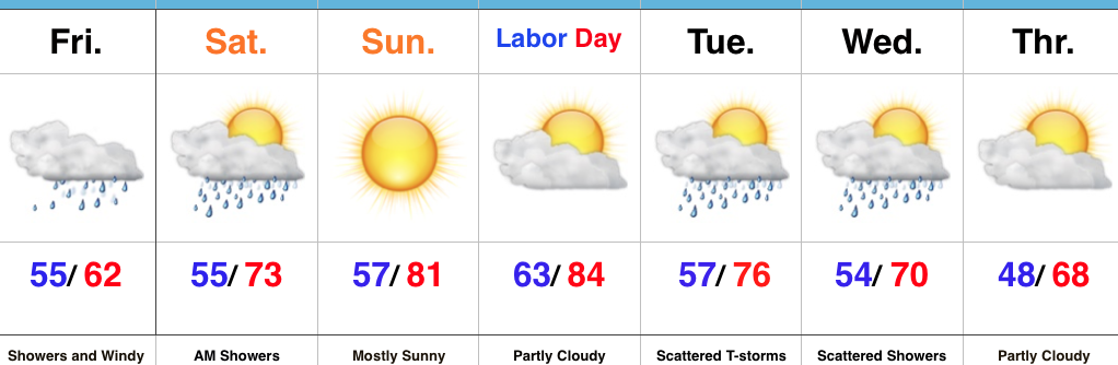
Improving Skies West To East Today…The remnants of Harvey led to heavy, wind-whipped, rain across southern and southeastern portions of the state Friday. Appropriately, today is the “transition day” towards brighter and briefly warmer times as Labor Day approaches. We’ll notice improving sky conditions from west to east today as the remnants of Harvey continue to track east. Today also won’t be nearly as windy as Friday. We awoke to temperatures at mid-October levels, including many in the 40s across central Indiana this morning. Despite the increasing sunshine, temperatures will run around 10° below average this afternoon.
A cold front will approach late Labor Day night and early Tuesday. Sunshine will dominate Monday, but we will note an increasingly gusty SW breeze by afternoon as the cold front draws closer. That front will slide through Tuesday and could have a scattered shower or thunderstorm with it as it passes (best chances of storms will be across the southern half of the state). Behind the frontal boundary, another shot of well below normal air (October-like) will descend into the region. With cold air aloft and just enough upper level energy around, widely scattered showers are possible during the afternoon hours Wednesday and Thursday.
Tropics: Irma will dominate weather headlines during the upcoming week. It’s far too early to know precisely where Irma will track, but folks with interests along the East Coast (from the southern FL peninsula all the way up to the north Atlantic coast) should monitor the progress of Irma closely. In addition to the likelihood of a major hurricane, the overall size of Irma will become larger as the week progresses.
Upcoming 7-Day Precipitation Forecast:
- Snowfall: 0.00″
- Rainfall: 0.10″ – 0.25″
 Highlights:
 Highlights:
 Highlights:
 Highlights: