VIDEO: Hurricane Irma And Warmer Times Loom…
You must be logged in to view this content. Click Here to become a member of IndyWX.com for full access. Already a member of IndyWx.com All-Access? Log-in here.
You must be logged in to view this content. Click Here to become a member of IndyWX.com for full access. Already a member of IndyWx.com All-Access? Log-in here.
 Highlights:
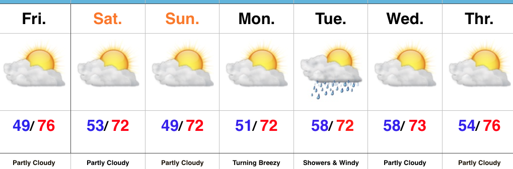
High Pressure Dominates…There’s no reason to get “wordy” with the short-term forecast, as high pressure will dominate our region. This will result in plentiful sunshine, low humidity, and unseasonably cool, refreshing temperatures. Find time to spend the weekend outside!
All eyes will most certainly be on dangerous Hurricane Irma as she begins to impact the Florida peninsula as early as Saturday. Our thoughts and prayers are with all in Irma’s path, including interior portions of the southeast that will also deal with hurricane conditions late in the weekend into early next week. Here on the home front, we still only expect minimal impacts from Irma. We’ll notice an increasingly gusty easterly breeze late Monday into Tuesday. Additionally, showers are possible (especially across the southern half of the state) Tuesday.
Upcoming 7-Day Precipitation Forecast:
 Highlights:
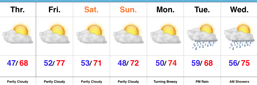
Unseasonably Cool; Irma Dominates Headlines…Upper level energy did, indeed, spark a couple of showers (even some small hail was reported in stronger showers) Wednesday evening. Here at IndyWx.com HQ, we picked up a quick half inch of much needed rainfall! While a couple of showers are possible once again this afternoon, these will be primarily confined to northern portions of the state. Otherwise, the balance of the upcoming forecast period is easy through the weekend: dry with reinforcing cool air arriving over the weekend.
Hurricane Irma will continue to dominate the headlines and will require our focus, locally, for potential impacts early next week. While we’ve built rain into our forecast Tuesday into Wednesday, it’s crucial to note this is an incredibly tough forecast and will require a great deal of fine tuning as we move forward. With that said, a blend of latest data and upper air analysis does suggest portions of the region (particularly eastern areas of the state) do stand a chance to get in on the action of Irma’s remnants Tuesday afternoon into Wednesday morning. Otherwise, breezy easterly winds are expected for the entire region beginning Monday evening. Stay tuned as we continue to analyze things. Thoughts and prayers are certainly with residents and family along the Southeast coast from southern FL to the Carolinas, including the southern Appalachian region. Speaking of, it should be noted Irma’s impacts will stretch well inland. Irma is forecast to remain a major hurricane wherever she comes ashore (window of opportunity for landfall up from the southern tip of FL all the way up to the Carolina coastline) and her forward speed into the southern Appalachians will combine with the rugged terrain and high elevations to create significant problems inland given the most up-to-date forecast track.
Upcoming 7-Day Precipitation Forecast:
 Highlights:
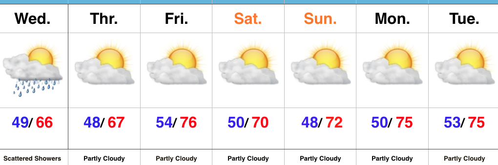
Jackets Required…Hoosiers are waking up to temperatures all the way down into the middle and upper 40s away from the city this morning (sure is hard to beat this crisp fall air). Sunshine will greet us out the door, but we’ll notice increasing cloudiness this afternoon and widely scattered thundershowers will follow. Most will stay dry, but enough upper level energy will interact with the cool air aloft to generate “pop corn” variety thundershowers this afternoon and evening. Additionally, highs in the mid 60s today and Thursday will be more like mid-October than early-September.
There’s no reason to waste a lot of pixels on the rest of the forecast period. Dry weather will dominate. Reinforcing cool air will arrive by the weekend and that cooler than average feel will remain throughout the forecast period. We’ll notice a gusty easterly wind at times late in the weekend and early next week as the pressure gradient tightens a bit between an area of high pressure to our northeast and Irma moving north into the Southeast.
Tropics: Irma continues to dominate the headlines, and rightfully so. This morning we have (2) additional storms: Jose and Katia. Jose is forecast to strengthen into a hurricane tonight, but should remain a “fish storm.” Katia will meander around the Bay of Campeche over the next few days and doesn’t pose a threat to the US.
Irma remains a category 5 beast this morning and overnight data continues to paint an ominous picture for the southeastern coast. Folks from the southern FL peninsula all the way up the coast to include the Carolinas need to remain abreast of the latest developments on Irma in the days ahead. Tropical storm conditions are expected to begin as early as Friday evening for southern Florida. Eventually, more of the southeast can expect impacts from Irma late weekend and next week, including interior areas such as the southern Appalachians…
Upcoming 7-Day Precipitation Forecast:
 Highlights:
More Like October Than September…A cold front moved through the region last night. As expected, there were “haves and have nots” with the frontal passage, including some rainfall totals over 2″ (especially north and east of the city) while other neighborhoods barely picked up a tenth of an inch.
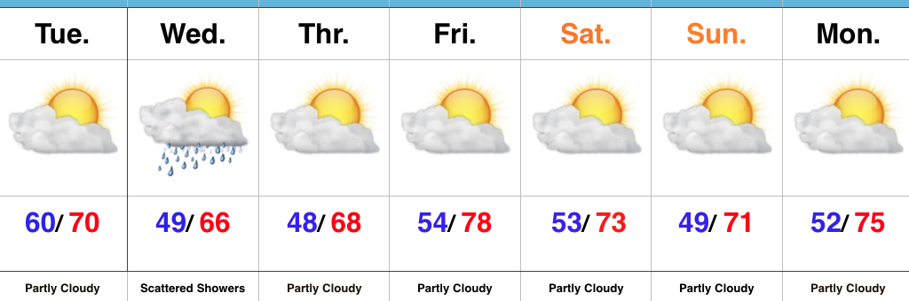
Northwest winds are blowing now and ushering in much cooler temperatures that will be with us through the forecast period. In fact, temperatures will turn so cool it’ll feel more like October (especially Wednesday and Thursday) than September. Additionally, upper level energy will help create scattered showers Wednesday (not a big deal).
Dry conditions will return as we wrap up the work week and head into early next week. Reinforcing cool air will arrive this weekend and we’ll also note a gusty easterly wind at times, thanks to the circulation between a high off to our northeast and Irma pushing north across the southeast region.
Tropics: Speaking of Irma, she continues to strengthen this morning and very near category 5 status. Preparations should be underway across the Florida peninsula now. We still have time to watch things unfold, but it’s looking increasingly likely that southern Florida will begin to feel tropical storm force winds as early as Friday, followed by a potential landfalling major hurricane over the weekend.
Upcoming 7-Day Precipitation Forecast: