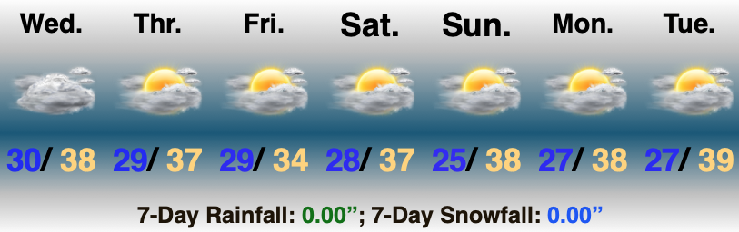
Category: 7-Day Outlook

12.30.20 Weather Bulletin: Timing Out Period Of Wet Snow By Evening; Icy Glaze To Open New Year’s Day…

Rain Ends As Wet Snow This Evening…A cold rain will continue to overspread central Indiana this morning. A cold front will slip south across the state through the afternoon and temperatures will fall into the 30s prior to sunset across most of the region. One final wave of moisture will push northeast across the area as temperatures fall into the low and mid 30s leading to a brief period of wet snow between 6p and 10p (northeast to southwest). We’re likely only looking at a window of 1-2 hours of snow at any one location, but it could fall moderate to heavy during that brief window and accumulate between a dusting and 1.5″. We’ll keep an eye on model trends through the day.

New Year’s Eve will feature dry, but gloomy and cold conditions. Look for overcast skies and highs struggling to make it to freezing.

Our second area of low pressure will lift north from the northwestern Gulf Coast into the Midwest Friday and Saturday. This will help widespread precipitation overspread the Hoosier state New Year’s Day (before sunrise for most). With cold air locked in at the surface, precipitation at the onset, continuing for a few hours north of a line from Terre Haute, Bloomington, and Cincinnati, will fall as freezing rain. If traveling early, we’d recommend caution as a light icy glaze (less than .10″ for most) is a good bet. Eventually warmer air will win out, switching things to a “plain ole rain” late morning into the afternoon.

Lingering showers will end Saturday as a trailing piece of upper level energy moves east across the Ohio Valley. Dry skies will return as we open up the new work week.

Permanent link to this article: https://indywx.com/12-30-20-weather-bulletin-timing-out-period-of-wet-snow-by-evening-icy-glaze-to-open-new-years-day/

VIDEO: Strong Arctic Front Crosses The State Tonight; Looking Ahead To A Busy Close To 2020…

The day is dawning with quiet conditions, but that all begins to change in significant fashion by evening. During the transition, strong and gusty winds (SW 45-50 MPH gusts) will…

You must be logged in to view this content. Click Here to become a member of IndyWX.com for full access.  Already a member of IndyWx.com All-Access?  Log-in here.

Permanent link to this article: https://indywx.com/video-strong-arctic-front-crosses-the-state-tonight-looking-ahead-to-a-busy-close-to-2020/

VIDEO: Strong Fall Front Whips Across The State Tonight…

You must be logged in to view this content. Click Here to become a member of IndyWX.com for full access.  Already a member of IndyWx.com All-Access?  Log-in here.

Permanent link to this article: https://indywx.com/video-strong-fall-front-whips-across-the-state-tonight/

2 Sides To Every Storm…

An early taste of winter is descending on the Rockies today (the town of Breckenridge camera will be fun to check in on from time to time over the next 24 hours). Places, such as Denver, that were in the 90s yesterday will fall into the 20s and 30s today with snow.

Note the big spread in temperatures across the country this morning and corresponding 24 hour temperature change:

We’ll remain on the mostly dry and warm side of this event until the weekend.

Once the storm system lifts northeast and gets close enough to impact our region, it’ll be in a much weaker state. Scattered showers and thunder are possible over the weekend, but widespread significant rainfall isn’t expected.

After heavy rains fell across north-central Indiana Monday, a much drier theme can be expected throughout the next several days. A widely scattered shower or thunderstorm is possible before Saturday, but most should remain rain-free. Even as the storm system draws closer, weekend rainfall should average only between 0.25″ and 0.50″ for most.

Cooler air (nothing to the extent or magnitude of what our friends out west are seeing) will filter in here late weekend and early next week. Lows into the 50s can be expected with a couple of days of highs in the 70s.

Permanent link to this article: https://indywx.com/2-sides-to-every-storm/

Weekly #AGwx And #Severe Weather Outlook…

I. Tracking multiple cold fronts this week.

II. Pattern transitions cooler than normal as we move through the 1st (10) days of September.

Temperatures will run close to seasonal norms up until Labor Day weekend before trending cooler than normal.
Precipitation in the week ahead will run slightly above average, locally. Most of the West will remain drier than normal, with the Deep South also dry. Wettest anomalies can be expected from the TN Valley into the Northeast.
We forecast between 0.50” to 1” of rain across central Indiana through the 7-day forecast period.

Forecast Period: 08.29.20 through 09.05.20

As we flip the page from meteorological summer to fall, a more active pattern can be expected, locally. Of course we already had one cold front sweep through the region this morning and we’re tracking 3 additional fronts between now and Labor Day. The 2nd front will move through midweek with scattered showers and storms Tuesday afternoon and Wednesday. The 3rd front will arrive Friday with yet another scheduled for a passage Labor Day night. Each front will provide an enhanced chance of showers and embedded thunder, but washouts aren’t anticipated any of the days through the upcoming week. Temperatures will run near seasonal norms before trending much cooler behind the Labor Day front (late September or early October like temperatures).

Permanent link to this article: https://indywx.com/weekly-agwx-and-severe-weather-outlook-20/