The day is dawning with quiet conditions, but that all begins to change in significant fashion by evening. During the transition, strong and gusty winds (SW 45-50 MPH gusts) will…
You must be logged in to view this content. Click Here to become a member of IndyWX.com for full access. Already a member of IndyWx.com All-Access? Log-in here.
You must be logged in to view this content. Click Here to become a member of IndyWX.com for full access. Already a member of IndyWx.com All-Access? Log-in here.
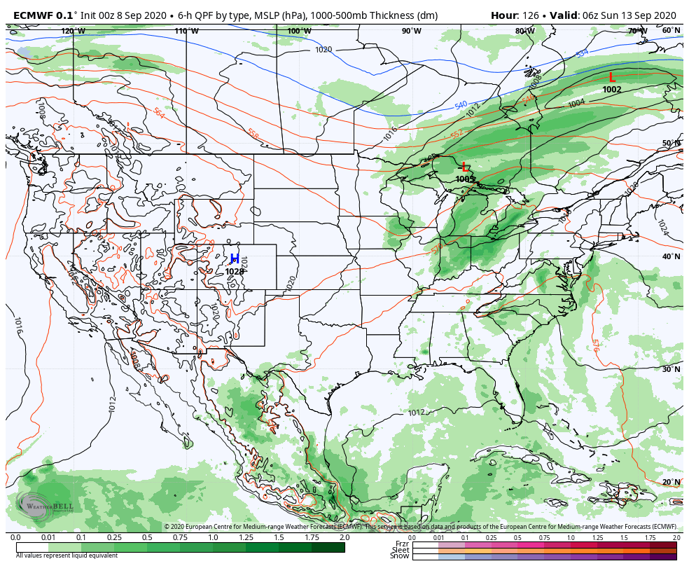
An early taste of winter is descending on the Rockies today (the town of Breckenridge camera will be fun to check in on from time to time over the next 24 hours). Places, such as Denver, that were in the 90s yesterday will fall into the 20s and 30s today with snow.
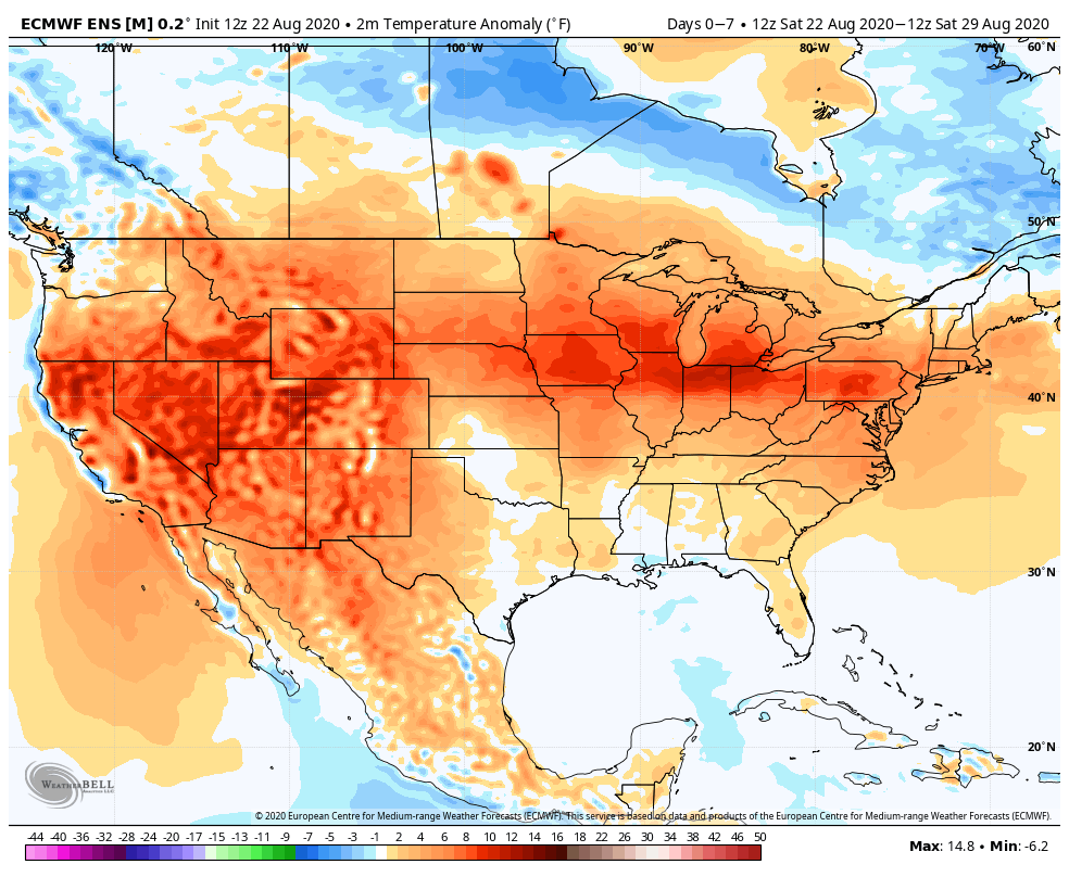
Note the big spread in temperatures across the country this morning and corresponding 24 hour temperature change:
We’ll remain on the mostly dry and warm side of this event until the weekend.
Once the storm system lifts northeast and gets close enough to impact our region, it’ll be in a much weaker state. Scattered showers and thunder are possible over the weekend, but widespread significant rainfall isn’t expected.
After heavy rains fell across north-central Indiana Monday, a much drier theme can be expected throughout the next several days. A widely scattered shower or thunderstorm is possible before Saturday, but most should remain rain-free. Even as the storm system draws closer, weekend rainfall should average only between 0.25″ and 0.50″ for most.
Cooler air (nothing to the extent or magnitude of what our friends out west are seeing) will filter in here late weekend and early next week. Lows into the 50s can be expected with a couple of days of highs in the 70s.
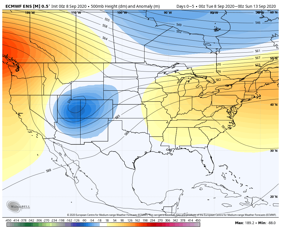
II. Pattern transitions cooler than normal as we move through the 1st (10) days of September.
Temperatures will run close to seasonal norms up until Labor Day weekend before trending cooler than normal. Precipitation in the week ahead will run slightly above average, locally. Most of the West will remain drier than normal, with the Deep South also dry. Wettest anomalies can be expected from the TN Valley into the Northeast.We forecast between 0.50” to 1” of rain across central Indiana through the 7-day forecast period.
Forecast Period: 08.29.20 through 09.05.20
As we flip the page from meteorological summer to fall, a more active pattern can be expected, locally. Of course we already had one cold front sweep through the region this morning and we’re tracking 3 additional fronts between now and Labor Day. The 2nd front will move through midweek with scattered showers and storms Tuesday afternoon and Wednesday. The 3rd front will arrive Friday with yet another scheduled for a passage Labor Day night. Each front will provide an enhanced chance of showers and embedded thunder, but washouts aren’t anticipated any of the days through the upcoming week. Temperatures will run near seasonal norms before trending much cooler behind the Labor Day front (late September or early October like temperatures).
II. Summer-like temperatures and humidity returns.
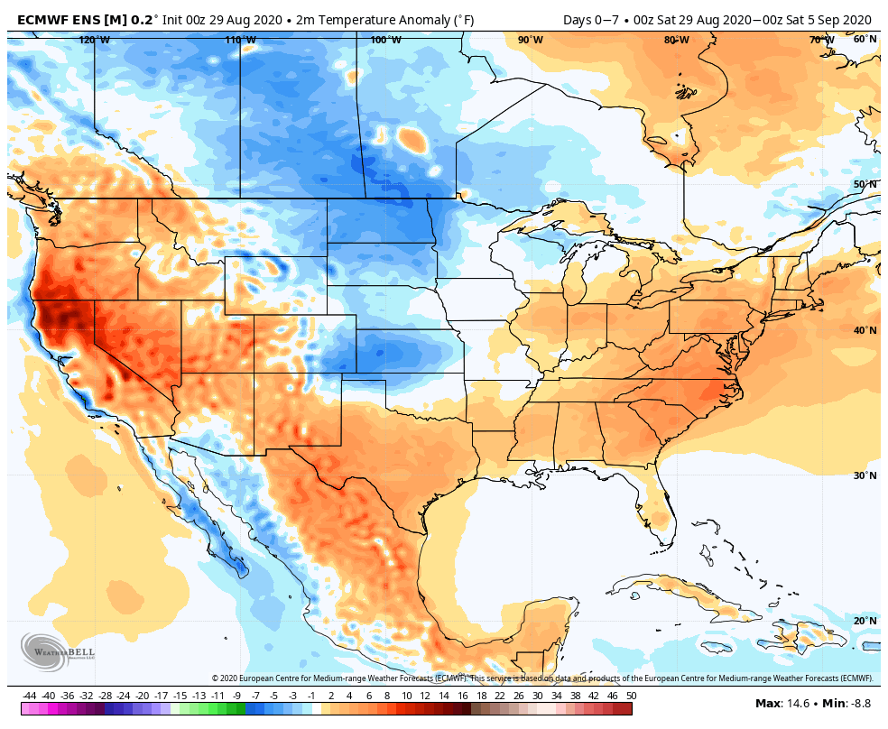
Coast-to-coast warmer than normal temperatures can be expected this week, with (2) areas of greatest anomalies: West and lower Great Lakes.
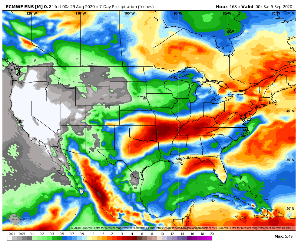
The central and western Gulf into the Deep South and TN Valley will see a flood threat this week as remnant tropical moisture moves inland.
We expect between 0.75″ and 1.5″ of rain this week for most of central Indiana.
Forecast Period: 08.22.20 through 08.29.20
A historic tropical event is likely to impact the Gulf of Mexico this week as not one, but two named tropical systems (likely both hurricanes) track north, northwest and target the central and western Gulf Coast. While additional fluctuations in the ultimate track and subsequent point of landfall can be expected over the next couple of days, confidence is increasing on the likelihood of 2 hurricanes making landfall within 36-48 hours of each other somewhere from the MS coast to the LA and TX coast. This won’t only be a coastal issue, but quickly grow into a big inland flood situation for the lower MS Valley and into the TN Valley as we get into the middle and latter parts of the week.
Back home, a much more typical summer-like regime can be expected this week, including a return of heat and humidity. While splash and dash coverage of storms is expected Sunday evening into Monday, most of the upcoming week looks rain-free, at least until late week. That’s when a stronger cold front will take aim on the region and increase shower and thunderstorm chances Thursday into Friday. To add further complexity into the equation, we’ll also have to monitor the remnant tropical moisture moving north, as it’s still possible some of this moisture gets entangled with the cold front. Whether or not this is the case or not is yet to be seen and will be the cause of great whaling and gnashing of teeth this week. Regardless, unlike with some tropical remnants, the upper pattern supports a fairly quick movement of the remnants once to midweek, so that would greatly limit flooding potential up this far north.
The early call on next weekend is for a drier regime to begin building in.