01.22.21 Weather Bulletin: Cold Weekend; Messy Open To The New Week Ahead…

Updated 01.22.21 @ 9:20a
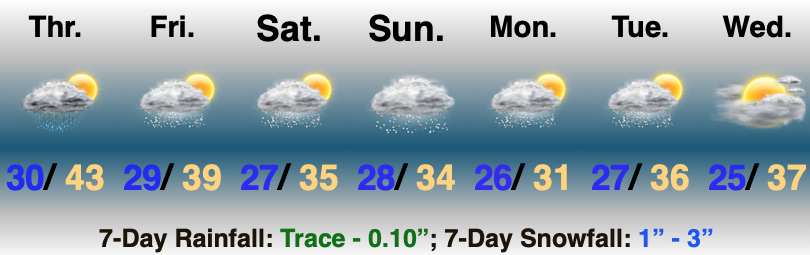
Focus Is On Next Week…The 1st half of the weekend is easy as high pressure builds into the area, supplying a fresh batch of cold, dry air. Enjoy the sun while you’ve got it. (Don’t anticipate much in the vitamin D department next week). Saturday morning will be very cold (middle 10s for most with single digit ‘chills).
Clouds will thicken up Saturday PM and an initial wave of moisture will arrive into central Indiana Sunday morning. This lead wave of precipitation should be on the light side but with cold air in place, it’ll likely fall as a wintry mix of sleet and potentially freezing rain across the southern half of the state. Where the cold air is a little deeper further north, the predominant precipitation type should take on the form of light snow Sunday morning.
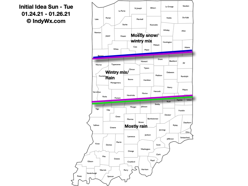
After a potential “lull” Sunday evening, another slug of moisture is inbound Sunday night and Monday. As surface low pressure tracks along the Ohio River during this time frame, this round of precipitation will be heavier and more organized. While this will still require fine tuning, our initial thinking is the form of precipitation will likely fall as the frozen variety across the northern 1/3 of the state with more mixing across immediate central Indiana, and predominantly liquid downstate. We’ll keep a very close eye on the data throughout the weekend, but our initial idea can be found below. Where the precipitation type is predominantly snow, this should be a “plowable” event. Stay tuned.
We’ll have to track another feature by the middle of next week. This could, too, deposit additional wintry conditions across the region, but we need to get through the lead system before trying to get too cute with the mid week feature.