02.03.21 Weather Bulletin: Keeping A Watchful Eye On The Weekend…
Updated 02.03.21 @ 8:19a
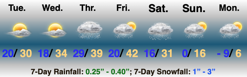
Best Day Of The Week…We can’t get too picky this time of year in the weather department. Long time fellow Hoosiers know to never take a day featuring sunshine for granted in early February. Though still chilly, given the pattern ahead, I’d recommend getting outside and enjoying some of those rays today.
A cold front blows into town Thursday and will deliver a chilly rain by the afternoon. As colder air rushes in on the backside of the system, rain will likely mix with and end as a period of snow across the northern half of the state Thursday evening. Though the moisture will be leaving as the cold air is arriving, we may still be able to squeeze out a dusting to 1″ of wet snow for northern areas.
Attention will then shift to an arctic wave that will move into the Ohio Valley this weekend. Snow will become widespread across the central Plains Friday evening into Saturday morning before expanding east into our neck of the woods Saturday afternoon into Sunday morning. With cold air in place, this will be a higher ratio snow event than we’ve seen so far this winter (“fluff factor” will be in full effect). Additionally, strong and gusty winds are expected during this time frame leading to blowing and drifting concerns. Stay tuned. We’ll take a stab at early accumulation numbers with this evening’s Client Video update.
Additional upper level energy will scoot through the region into early next week, keeping a supply of snow showers ongoing. While still cold, models have pushed back the truly dangerous cold until late week. Case of delayed, but not denied? Unfortunately think so…