02.14.21 Weather Bulletin: Memorable Week Of Winter Weather…

Updated 02.14.21 @ 8a

Back-to-Back Heavy Snow Storms…Use today to complete preparations for what will be a memorable week of winter weather. While bitter out this morning, we’ll at least enjoy a dry day. Wind chills that are at dangerous levels right now (-10° to -20°) will “warm” to between 0° and 5° above this afternoon.

Snow will overspread the state from southwest to northeast as we move through the night. Initially, we’re talking about mostly light snow, but roadways will be a mess for the morning commute Monday (given how cold it’s been as of late). If you can avoid travel altogether, we’d recommend doing so. Snow will really begin to pick up in intensity after lunchtime Monday, and especially towards evening, continuing into the overnight hours. Periods of heavy snow can be expected during this time frame. The snow will be mostly out of here by Tuesday morning, but not before depositing a widespread 5″ to 8″, including localized amounts up to 10″. You’ll want to get on the clean up from the first storm as another “big one” awaits.

After a mostly dry Tuesday and daytime Wednesday, light snow will develop towards sunset and become heavy at times Thursday. This second storm has the potential to be equally, if not more, significant than its predecessor and we’ll have early snowfall numbers issued this afternoon. By Friday morning, widespread snowfall totals of 10″ to 15″ (if not more in spots) can be expected with drifts in the open country that even a yardstick won’t be able to handle.

We’ll have our updated snowfall maps included with our Client video update that will be published this afternoon. A Client Brief will be posted later today, as well, focusing on the specific details of Storm #1.

02.12.21 Weather Bulletin: Continuing To Keep Close Eyes On Next Week…

Updated: 02.12.21 @ 7:34a

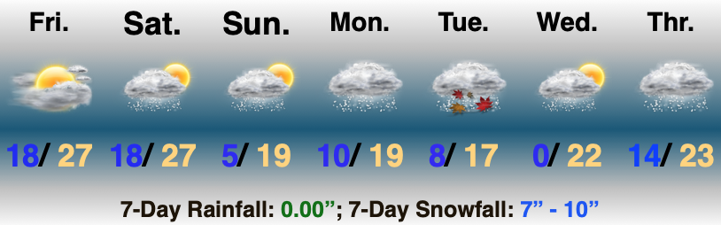
Use This Weekend To Prep…The short-term portion of this forecast is relatively quiet. Take advantage and prepare for significant winter weather next week. We may even see a few breaks in the cloud cover today. All in all, look for mostly cloudy and continued cold conditions. Keep in mind, average highs this time of year should be close to 40°. We’ll be nowhere near that anytime soon. In fact, most days will feature high temperatures even colder than average lows for this time of year!

Reinforcing arctic air will penetrate the area Saturday and will likely kick up some light snow showers- especially during the afternoon. Light snow will remain a possibility Valentine’s Day, but “light” is the key word.

The more exciting part of this forecast comes at us as we open the work week. Surface low pressure will develop in the northwest Gulf of Mexico Sunday night and track northeast up along the Appalachians. This will spread a swath of snow into the Ohio Valley through the day Monday. It appears as if snow will become heavy at times Monday evening into the predawn hours Tuesday before tapering to light snow/ snow showers late Tuesday morning. This will be a much more powdery snow than we typically see with these Gulf storms, due to having truly arctic air involved with the storm. Gusty winds will create significant blowing and drifting issues throughout the early and middle portion of the work week.

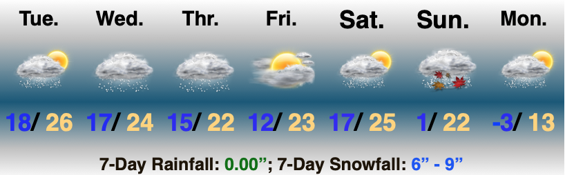
That then leads us to the threat of another significant winter storm as we push into Wednesday night into Friday morning. We don’t want to get ahead of ourselves, but the threat is very real that this storm also deals out heavy impacts across the region with additional heavy snow possible during the aforementioned time frame.

We’d suggest using the weekend to prepare for the potential of two back-to-back “big deal” winter storms. We’ll be here through the weekend with additional updates.

Averages: H: 39/ L: 23° on the 12th –> H: 41°/ L: 25° on the 18th

02.09.21 Weather Bulletin: “Active” Would Be An Understatement…

Updated 02.09.21 @ 8a

Keep That Head On A Swivel…Before we talk about what’s ahead, it was a snowy night across south-central Indiana. Many of the reports coming in from down that way indicate our 3″ to 5″ forecast played out quite nicely, including most common snowfall totals between 4″ and 5″ (with a few isolated heavier amounts). Thank you for those ground truth reports, friends! I know we’ve said it before, but they are more valuable than you know!

Now to look ahead. Storm systems will come flying through fast and furious over the upcoming 7-days. Scattered lingering snow showers and flurries today will give way to a steadier snow as we move into Wednesday. Meanwhile, an icy mixture of sleet and freezing rain is expected across far southern Indiana. After the 12z model suite is complete this afternoon, we’ll be back with a fresh look on expected snowfall amounts later this evening.

Friday appears to offer up a much needed one day breather from wintry systems with cold, dry conditions expected. Then our attention will shift to the weekend and threat of potentially a more significant winter storm. Guidance is trying to sort out which feature has the best chance of phasing into a more potent storm system. The GFS likes the lead wave this weekend while the European holds things off until early next week. Please stay tuned.

02.03.21 Weather Bulletin: Keeping A Watchful Eye On The Weekend…

Updated 02.03.21 @ 8:19a

Best Day Of The Week…We can’t get too picky this time of year in the weather department. Long time fellow Hoosiers know to never take a day featuring sunshine for granted in early February. Though still chilly, given the pattern ahead, I’d recommend getting outside and enjoying some of those rays today.

A cold front blows into town Thursday and will deliver a chilly rain by the afternoon. As colder air rushes in on the backside of the system, rain will likely mix with and end as a period of snow across the northern half of the state Thursday evening. Though the moisture will be leaving as the cold air is arriving, we may still be able to squeeze out a dusting to 1″ of wet snow for northern areas.

Attention will then shift to an arctic wave that will move into the Ohio Valley this weekend. Snow will become widespread across the central Plains Friday evening into Saturday morning before expanding east into our neck of the woods Saturday afternoon into Sunday morning. With cold air in place, this will be a higher ratio snow event than we’ve seen so far this winter (“fluff factor” will be in full effect). Additionally, strong and gusty winds are expected during this time frame leading to blowing and drifting concerns. Stay tuned. We’ll take a stab at early accumulation numbers with this evening’s Client Video update.

Additional upper level energy will scoot through the region into early next week, keeping a supply of snow showers ongoing. While still cold, models have pushed back the truly dangerous cold until late week. Case of delayed, but not denied? Unfortunately think so…

02.01.21 Weather Bulletin: The Arctic Hounds Come Calling…

Updated 02.01.21 @ 6:34p

Bottom Drops Out Early Next Week…Brief high pressure will build overhead through the next 24 to 48 hours and supply a return of sunshine. We may still have a few light flurries around through the early afternoon Tuesday, but the story over the next couple of days will be improving weather, albeit still chilly.

Our next storm system will approach Wednesday night and Thursday in the form of a cold front. Precipitation should arrive Thursday morning as a cold rain (might start as a brief wintry mix, but this shouldn’t be a big deal). The cold front will then sweep through the state Friday morning. Highs will likely take place during the predawn hours with falling temperatures through the day. Any lingering morning precipitation should exit stage right relatively quickly.

Things become much more interesting over the weekend as a couple of arctic fronts sweep across the region. The first front will feature vigorous upper level energy and will likely result in a period of snow. The second front will really drop the “arctic hammer” and not only lead to the coldest air we’ve seen in quite some time, but a continuation of snow chances into early next week.

We’ll keep a close eye on the development of things for the weekend. With arctic air getting involved, it’ll likely maximize any available moisture and a couple of seemingly rather “harmless” snow events could turn into over-achievers as we grow closer. I’d keep close tabs on the weekend forecast.

Bitter air will pour into the region early next week, including dangerously cold wind chill values. Those with ag/ livestock interests should be prepared to make adjustments for the severe cold.