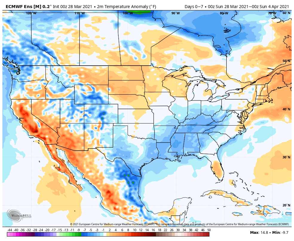
Temperatures will run below normal through the upcoming period from the Ohio Valley into the Southeast. Meanwhile, resurgent warmth will build across the northern Plains.
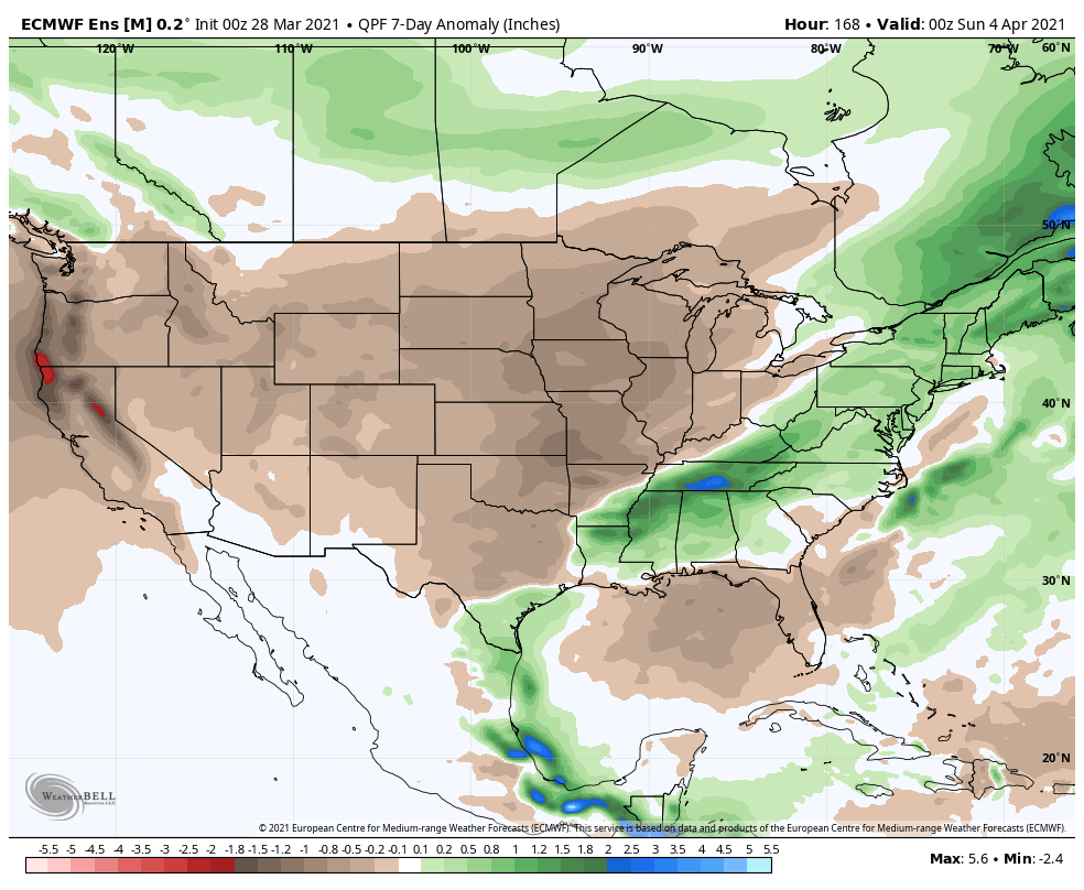
After an active stretch of weather, an overall drier pattern will build in through the upcoming period across the Plains and into the Ohio Valley. Meanwhile, the eastern seaboard will remain wetter than normal.
We forecast central Indiana to receive a half inch or less of rain over the upcoming 7-day period (most of that comes this morning and again with a frontal passage Tuesday night).
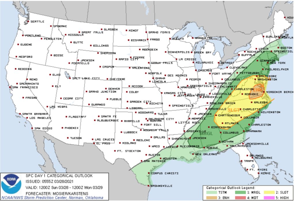
The most active severe weather day of the 7 upcoming will be today- primarily east of the mountains and into the Mid Atlantic region into the Southeast.
Forecast period: 03.28.21 through 04.04.21
You don’t need us to remind y’all just how active and busy things have been over the past couple of weeks. For those weather weary, an extended period of overall quieter weather will build in for the upcoming week. The only exception to that will be some early showers today and again with a frontal passage Tuesday night-predawn Wednesday. The bigger story will be the pop of unseasonably cold air that will arrive on the heels of the passage of the midweek cold front. We’re talking about some neighborhoods falling into the 10s by late week for morning lows. Brrrrr. Thankfully, the cold won’t last more than a couple of days and we’ll be back to moderating conditions as Easter Sunday arrives.
I. Tracking 2 coast-to-coast storms in the week ahead
II. Severe episodes begin to increase
Coldest anomalies will be centered over the deep snowpack across the Front Range. The Midwest and OHV region will run above to well above normal in the temperature department.
Well above normal precipitation will target the middle of the country, including into the Southeast.
We forecast between 1.25″ and 1.75″ for *most central IN rain gauges over the upcoming 7 days.
Each day this upcoming week will feature a threat of severe weather (including tornadoes), focused on the Plains and into the Southeast. That said, even into the OHV, a threat of stronger storms is present by midweek.
Widespread severe drought conditions persist across the 4-Corner region.
Forecast period: 03.14.21 through 03.21.21
An active week is in store for the region as a series of storm systems impacts the area. The first system will deliver widespread heavier precipitation (after today’s light, nuisance variety rain/ drizzle) late morning Monday into the afternoon hours. With just enough cold air in place, there’s the possibility this precipitation will mix with sleet and freezing rain from Indianapolis and points north briefly at the onset. That said, the wintry precipitation types won’t last long and things will quickly changeover to a plain ole rain by early to mid afternoon. Scattered showers and a possible embedded storm will continue Tuesday as the surface low moves through the Ohio Valley.
Storm #2 quickly follows for St. Patrick’s Day. While we still have some time to fine tune things, I’d suggest keeping an eye on Wednesday afternoon for the possibility of stronger storm potential as far north as central IN and more of the Ohio Valley as a whole. The ingredients aren’t the best, but there seems to be just enough warmth and instability to at least warrant a close eye for this time period. We’ll do just that and update our products accordingly.
Quieter weather will build into the area by the weekend.
II. Heavy rain/ potential flooding threat looms late week across OHV
Widespread above normal temperatures can be expected this week. Only exception to this will be across the West and far Southeast.
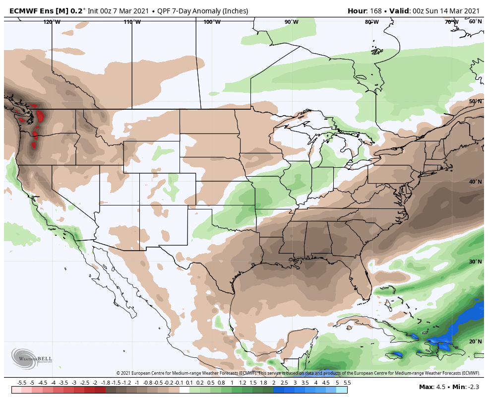
Above normal precipitation will target the MO Valley and into the western OHV.
We expect between 1″ and 2″ for most of IN in the week ahead.
Widespread significant drought continues across the West, especially Southwest/ Four-Corners region.
Forecast period: 03.07.21 through 03.14.21
While our weather will remain “eerily quiet” to open this forecast period, significant changes await on deck by the 2nd half of the week. These changes will be ushered in from a cold front that will lead to increasing shower (maybe even embedded t-storm) chances Thursday before rain becomes widespread Thursday night into Friday. The GFS and European computer models begin to disagree on the evolution of things next weekend. The GFS stalls the front just to our south before a surface wave of low pressure rides along the boundary over the Saturday-Sunday period. Meanwhile, the European shoves the front off to the south in a quicker fashion, allowing for a drier weekend. We’ll need to keep a close eye on things and update in the days ahead. Should the GFS idea be correct, a flood threat would ensue, including weekend rainfall totals of several inches. We’re not ready to jump on the excessive rainfall idea yet, due to the differences in the handling of the frontal boundary/ associated surface wave, but will keep a very close eye on things. Stay tuned.
About As Quiet As It Can Get…March couldn’t feature any quieter conditions to open up the month. It’s almost eerily quiet… High pressure will dominate our weather and supply an extended stretch of dry conditions. We’ll “flirt” with milder air Wednesday before a brief setback to close the week. Then, it’s off to the races next week, including several days that should go well into the 60s!
The next chance of meaningful precipitation doesn’t appear to be on the horizon until early to middle parts of next week.
Averages: H: 45°/ L: 28° on the 1st –> H: 48°/ L: 30° on the 8th
II. Eastern, Southeastern regions cool late in the period
Overall, over the upcoming 7-day period, above normal temperatures are expected from the northern Plains into the Southeast, including OHV.
Precipitation is expected to run above normal across the Southeast, TN Valley, and lower OHV.
Rainfall should run between 0.75″ and 1.25″ for central IN over the upcoming 7-days.
There is a threat of severe weather today from the Ark-la-tex region into the western TN Valley.
Widespread significant drought continues across the West, especially Southwest/ Four-Corners region.
Forecast period: 02.28.21 through 03.07.21
The short-term will be dominated by a the wet (and stormy for some) time of things from the OH Valley, but more so centered in the TN River Valley. Eventually the associated frontal boundary will sweep into the Southeast region early in the work week before stalling out and serving as the focal point for additional storm systems mid and late week. The first of these systems will scoot from the southern Plains east into the Southeast in the Monday through Wednesday time period with additional opportunities for heavy rain and local severe weather. We’ll watch for another suppressed system late in the week that will likely take a similar route in the Thursday-Saturday timeframe.
From a central Indiana standpoint, best rain chances out of the entire period are in front of us now. Things should dry out considerably through the balance of the upcoming work week given the overall pattern.