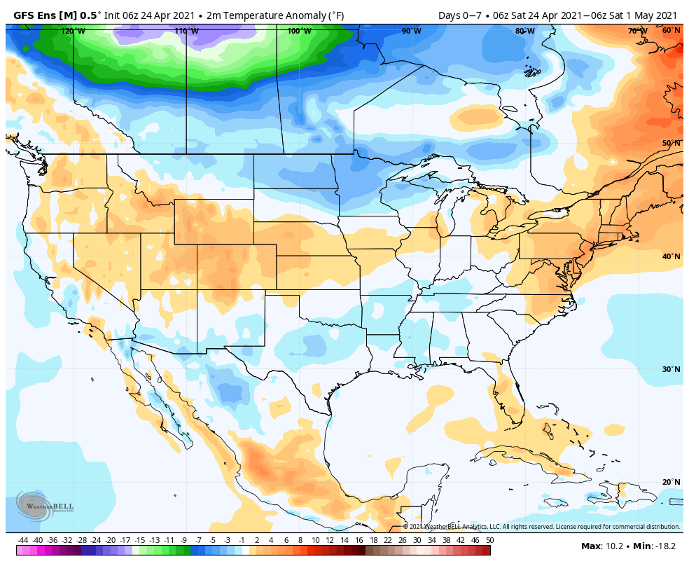
Temperatures will moderate from the unseasonably cold conditions as of late. We’ll make a run for 80° by Tuesday here in central IN.
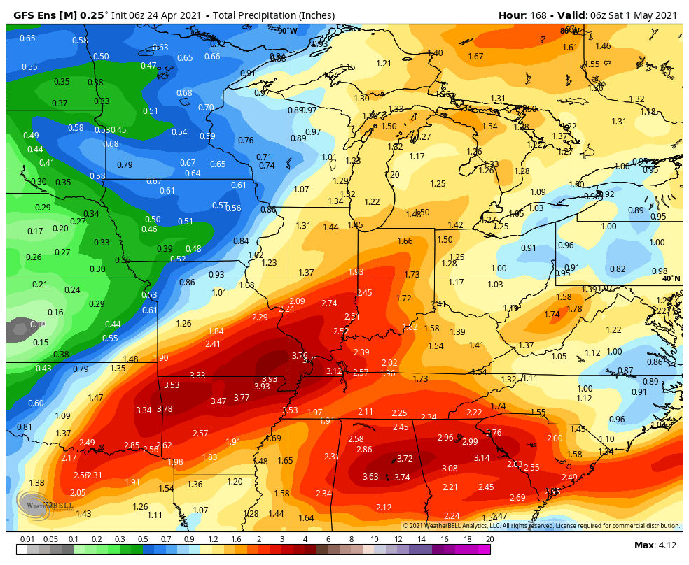
Above normal rainfall is expected in the week ahead from the mid MS Valley and Gulf Coast into the Ohio Valley and Great Lakes.
We forecast most central IN rain gauges to receive between 1.75″ and 2.25″ in the week ahead.
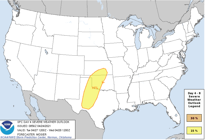
A new spring storm will emerge out of the Plains Tuesday and likely ignite a round of severe weather throughout tornado alley.
Forecast Period: 04.24.21 through 05.01.21
A relatively weak storm system will lead to plenty of clouds today and a couple of light passing showers (better chance of steadier rain downstate). This system will blow by to our east tonight and allow a drier air mass to build into the region as we move through the 2nd half of the weekend, complete with a return of sunshine! Enjoy the sunny and much warmer open to the week as significant changes await by Wednesday. Before this, a strengthening southwesterly air flow will push high temperatures into the lower 80s Tuesday! Attention will then shift to a complex and multifaceted storm system that will deliver heavy rain and thunderstorms (potential present for a couple stronger storms midweek that we’ll continue to monitor) in rounds Wednesday through Friday. While it won’t rain the entire timeframe, periods of heavier rain can be expected. We’ll dry things back out heading into next weekend.
You must be logged in to view this content. Click Here to become a member of IndyWX.com for full access. Already a member of IndyWx.com All-Access? Log-in here.
You must be logged in to view this content. Click Here to become a member of IndyWX.com for full access. Already a member of IndyWx.com All-Access? Log-in here.
Permanent link to this article: https://indywx.com/video-snap-back-ahead-but-likely-transitional-reasons-were-leaning-towards-a-cooler-than-normal-may/
A cooler trend will develop this week from the Plains into the Ohio Valley. Meanwhile, unseasonable warmth will hang on a couple more days across New England.Below normal precipitation is expected this week across a widespread chunk of the Lower 48. One major exception to that will be found along the Gulf Coast.
Rainfall totals should fall within 0.25” and 0.50” for immediate central Indiana this week and most of that will come today.
Another round of severe weather is expected across Florida today, unfortunately impacting spring breakers. All in all this will be a quieter week on the severe front as the cooler pattern settles in.
Forecast Period: 04.11.21 through 04.18.21
Central Indiana will continue to feel the affects of the low pressure system that resulted in periods of storms yesterday through the remainder of the weekend. A rather persistent light to moderate rain is expected today along with gusty winds and cooler air. This system will pull east of the region Monday and allow for drier air to return. The bulk of the remainder of the forecast period looks dry and seasonably cool. We’ll continue to keep an eye on upper level energy scooting to our east midweek. This is expected to result in a few instability-driven showers for our friends across northeastern IN into OH, but continues to look like it’ll just miss central IN.
Frosty conditions are still possible Thursday morning, especially if we can clear out any lingering clouds from the aforementioned upper energy. The next opportunity for better coverage of light showers won’t come until next weekend. Overall we only expect 0.25” and 0.50” of rain in the week ahead- most if not all of which falls today.
First and foremost, we want to wish you and your family a blessed Easter Sunday. Weather will be absolutely gorgeous, including sunny skies and highs that will top out in the lower 70s this afternoon! Enjoy!
Widespread well above normal temperatures can be expected this week. Greatest deviation from normal will be found across the Great Lakes and Ohio Valley.
Large scale drier than normal conditions are on tap. Exception to this will be across the upper Midwest and central Gulf Coast region.
We forecast between 0.50″ and 1″ of rain to fall on most central Indiana lawns over the upcoming 7-day period.
An outbreak of severe weather is expected across the central Plains (starting Monday night and Tue) and into the lower MS Valley by midweek.
Forecast period: 04.04.21 through 04.11.21
High pressure will dominate our weather to open the forecast period. This will result in a gorgeous Easter Sunday and extend into the early portion of the work week. We’ll notice humidity levels slowly climbing and a few more clouds will be around, but otherwise very nice conditions will prevail through most of the daytime Tuesday. Unseasonably warm conditions can be expected throughout the week ahead. Shower and thunderstorm chances will begin to increase Tuesday night and coverage will really ramp up through midweek. While the bulk of the severe weather is expected south of here, we’ll want to keep an eye on the potential of a couple stronger storms here Wednesday PM. The slow moving system should push east of here Friday evening, allowing high pressure to build back in as we open up next weekend.