Updated 09.23.21 @ 7:44a
You must be logged in to view this content. Click Here to become a member of IndyWX.com for full access. Already a member of IndyWx.com All-Access? Log-in here.

Sep 23
Updated 09.23.21 @ 7:44a
You must be logged in to view this content. Click Here to become a member of IndyWX.com for full access. Already a member of IndyWx.com All-Access? Log-in here.
Permanent link to this article: https://indywx.com/video-improving-conditions-to-close-the-work-week-changeable-week-ahead/
Mar 21
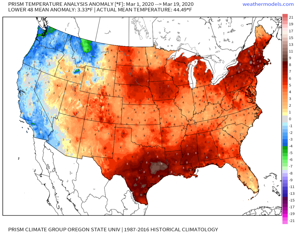
March to-date is running warmer and wetter than average across not only central Indiana, but a good chunk of the central and eastern part of the country.
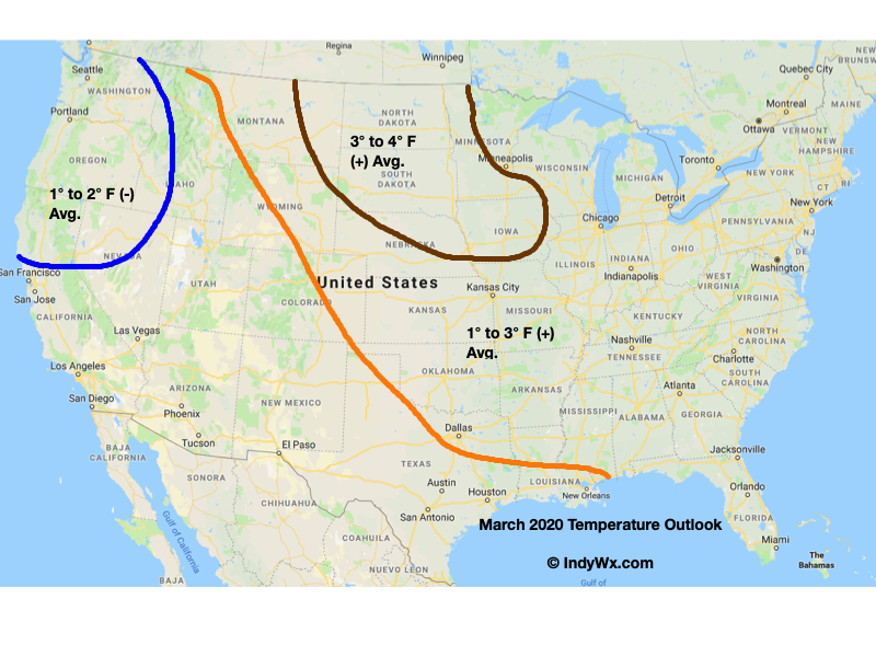
For comparative purposes, our March Temperature Outlook is above. It’ll be interesting to see how everything shakes out by month’s end.
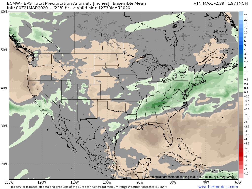
We anticipated a wet month, as well, into the middle MS Valley into the Ohio Valley, and eastern Lakes/ Northeast.

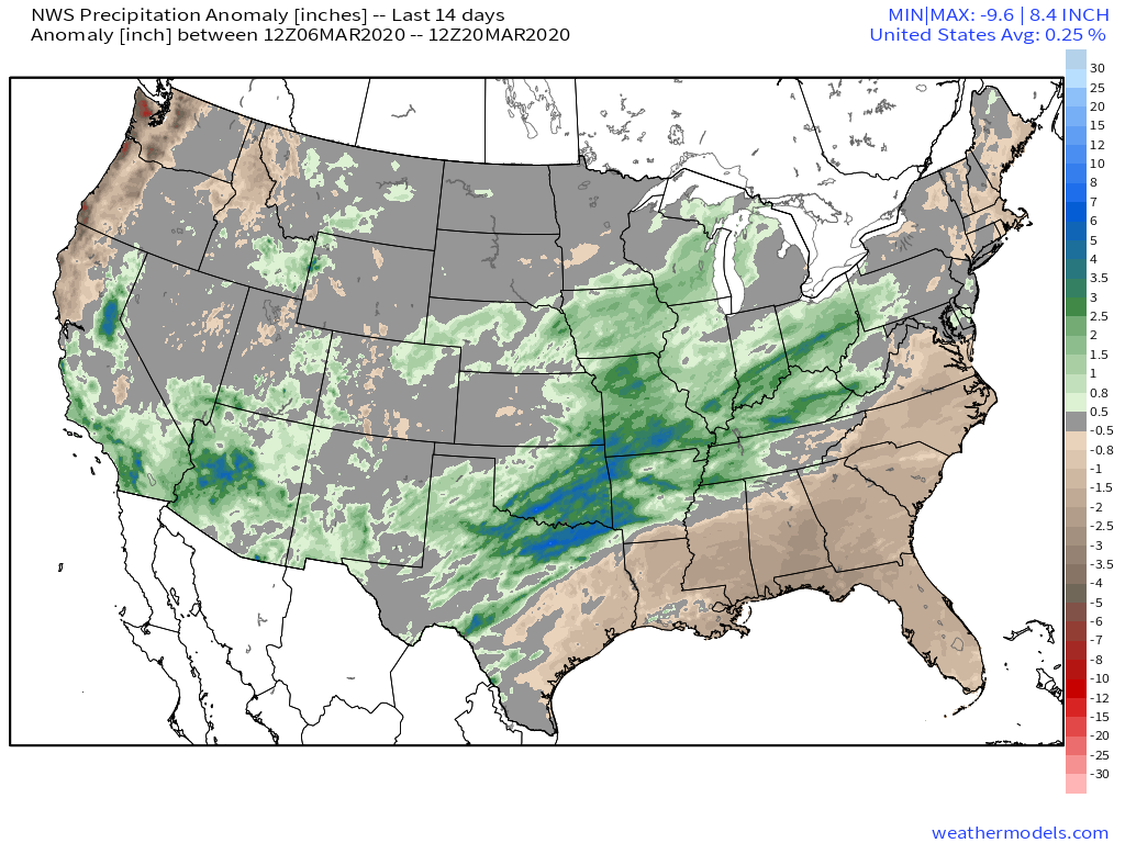
Indianapolis is running a little more than 1″ above normal in the rainfall department, and this will grow larger as we progress through the next (10) days.
This upcoming week, alone, we expect storm systems to deliver rain Sunday PM, Tuesday PM, and again late Thursday into Friday. Widespread central Indiana rainfall totals are currently pegged between 1″ and 1.5″, but given the pattern, it wouldn’t surprise me to see those numbers increase as we go forward. Thankfully, there aren’t any storms on the immediate horizon that look to be big severe weather producers, locally.
Despite this weekend’s chill, the balance of what’s left in the month should run well above average across the eastern half of the country.

More on what we think April will provide a bit later…
Permanent link to this article: https://indywx.com/march-to-date-and-looking-ahead/
Dec 29
You must be logged in to view this content. Click Here to become a member of IndyWX.com for full access. Already a member of IndyWx.com All-Access? Log-in here.
Permanent link to this article: https://indywx.com/video-wet-close-to-the-weekend-wintry-threats-loom/
Oct 21
You must be logged in to view this content. Click Here to become a member of IndyWX.com for full access. Already a member of IndyWx.com All-Access? Log-in here.
Permanent link to this article: https://indywx.com/video-sifting-through-the-noise-as-we-close-october-and-open-november/
Oct 03
Today is the day of a significant and more permanent transition from our “bonus” summer to a cooler journey ahead.
The ‘mean’ upper air pattern will feature a trough over the eastern portion of the country and associated temperature pattern more like we’d expect for early to mid October.


With the cooler air, we’ll also notice a more active pattern, as well. A model blend paints the potential of 0.50″ to 1.50″ of rain over the upcoming 10-day stretch. More specifically, we’re targeting dates for frontal passages on the following:
I. Thursday, 10.3
II. Sunday, 10.6
III. Friday, 10.11
The Sunday frontal passage and late Week 2 cold front will offer up better chances of more widespread precipitation.

Permanent link to this article: https://indywx.com/as-harvest19-kicks-off-timing-out-storms-into-mid-october/