Updated 07.31.23 @ 7:58a
You must be logged in to view this content. Click Here to become a member of IndyWX.com for full access. Already a member of IndyWx.com All-Access? Log-in here.

Jul 31
Updated 07.31.23 @ 7:58a
You must be logged in to view this content. Click Here to become a member of IndyWX.com for full access. Already a member of IndyWx.com All-Access? Log-in here.
Permanent link to this article: https://indywx.com/2023/07/31/video-pleasant-open-to-the-work-week-rain-and-storm-chances-return-late-week/
Jul 30
Updated 07.30.23 @ 11:25a
I. We can already feel a difference in the nature of the airmass this morning, but there’s a much bigger push of dry air inbound tonight. By Monday morning, dew points across central Indiana will fall into the 40s and 50s- a far cry from the oppressive “jungle-like” dew points from last week. Talk about a breath of fresh air. The good news in this pleasant airmass will hold through the middle of the week.
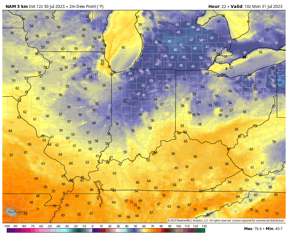
II. While we can’t totally rule out a shower this afternoon, most of the period will remain rain-free between now and Wednesday. Look for plentiful sunshine through this period as well.
Rain and storm chances will return towards the latter part of the week. While we’re not expecting any sort of washout, it’ll be a good idea to have a Plan B in mind from Thursday through the weekend in the event a storm cluster threatens from time to time.

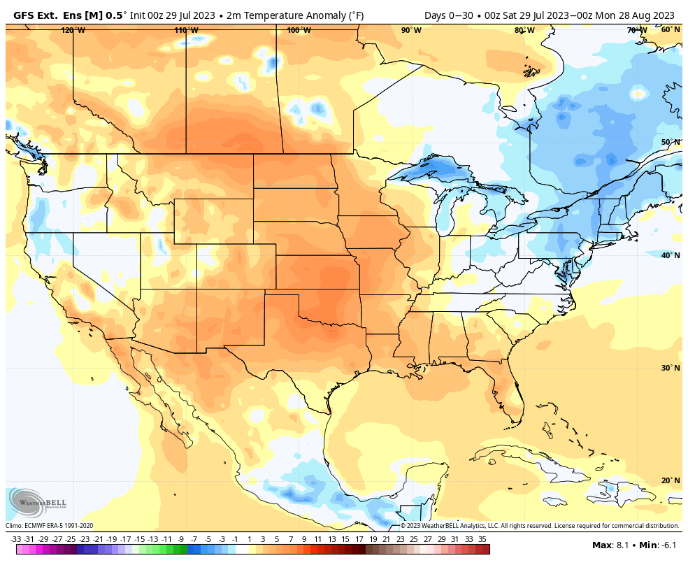
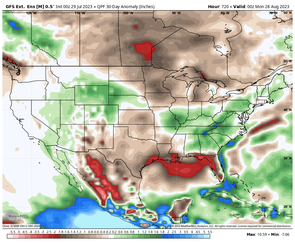
III. Over the next couple weeks, the primary pattern drivers continue to look like a combo of the EPO and PNA- both of which will, for the most part, be in favorable phases to deliver seasonal to slightly cooler than normal conditions across our neck of the woods. At times, it’s appeared like the MJO will start to amplify, but that hasn’t been the case and doesn’t appear to be a big player in our pattern through mid August, at least. Bottom line, our idea is that August features seasonal temperatures, as a whole, with slightly above normal rainfall throughout central Indiana. (For perspective, the average high at IND in August is 84.3° with an average low of 65°. On average, we pick up nearly 3.5″ of rain during any given August).
The most anomalous and long-lasting heat should continue to be featured across Plains and points west with coolest anomalies across the Northeast.
Permanent link to this article: https://indywx.com/2023/07/30/sunday-morning-rambles-much-less-humid-start-to-the-week-updated-thoughts-on-the-august-pattern/
Jul 29
Updated 07.29.23 @ 10:25a
You must be logged in to view this content. Click Here to become a member of IndyWX.com for full access. Already a member of IndyWx.com All-Access? Log-in here.
Permanent link to this article: https://indywx.com/2023/07/29/major-improvements-on-the-way/
Jul 28
Updated 07.28.23 @ 8a
You must be logged in to view this content. Click Here to become a member of IndyWX.com for full access. Already a member of IndyWx.com All-Access? Log-in here.
Permanent link to this article: https://indywx.com/2023/07/28/heat-takes-a-back-seat-to-an-unseasonably-cool-open-to-august-strong-storms-in-between-the-transition/
Jul 27
Updated 07.27.23 @ 7:20a
You must be logged in to view this content. Click Here to become a member of IndyWX.com for full access. Already a member of IndyWx.com All-Access? Log-in here.
Permanent link to this article: https://indywx.com/2023/07/27/video-hot-and-humid-with-a-few-storms-to-close-the-week-cooler-times-await-to-open-the-new-week/
Jul 26
Updated 07.26.23 @ 7:15a
You must be logged in to view this content. Click Here to become a member of IndyWX.com for full access. Already a member of IndyWx.com All-Access? Log-in here.
Permanent link to this article: https://indywx.com/2023/07/26/video-analyzing-tonights-severe-threat-heat-levels-back-off-over-the-weekend/
Jul 25
Updated 07.25.23 @ 5:13a
We’re running slightly cooler than normal, month-to-date, across central Indiana. (0.5° below normal at IND). Above normal temperatures have ruled the day along the coasts with the cooler anomalies in the Plains and into the western portions of the Ohio Valley.
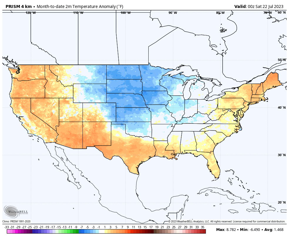
A big flip in this regime will take place as we push through the upcoming work week. Note the expanding heat in areas where it’s been cool so far this month.

As the hot dome nudges east, central Indiana will make up for lost ground in the 90° department. In fact, the hottest and most humid air of the season will take up shop mid and late week. Low-mid 90s with overnight lows not falling below the oppressive 70° mark can be expected.
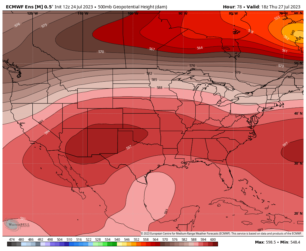
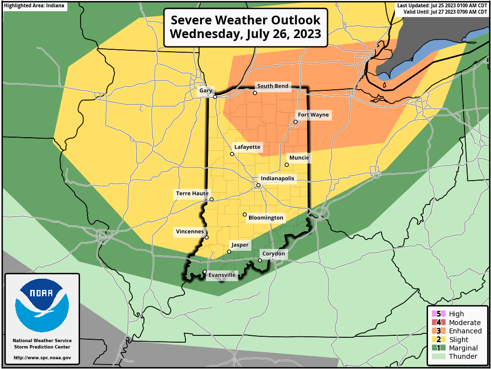
That said, we remain stubborn in believing this will be a transitional heat wave. The EPO (East Pacific Oscillation) and PNA (Pacific North America pattern) are both heading in directions that should force the ridge (hot dome) west in the Week 2 time period. This will open the door for cooler and more active weather to return, locally. We’ll likely have to deal with multiple strong-severe storm complexes tracking in northwest to southeast fashion into early August. Speaking of severe weather, all of the region is under fire for a couple rounds of storms Wednesday. Morning convection will likely remain below severe levels but a potent complex of storms is expected to redevelop Wednesday afternoon and evening. Given the ingredients and severe weather parameters in play Wednesday, all modes of severe weather will be possible, including the potential of a couple strong tornadoes. Needless to say, it’ll be a day to remain weather-aware.

In closing, when looking at the long range pattern, the wild card has to do with the MJO (Madden Julian Oscillation). Should this become more amplified, then the shift in the regime will be more dramatic. As it is, we’re far from ready to make a call on this becoming more amplified (a bigger driver in the pattern transition). The thought this could be heading into Phase 6 is less of a likely situation now compared to a few days ago, but we’ll continue to closely monitor the progression all the same. The combination of the EPO/ PNA trends will serve as the baseline in building our longer range forecast for now.
Permanent link to this article: https://indywx.com/2023/07/25/what-the-pattern-drivers-have-to-say-about-longevity-of-building-heat/
Jul 24
Updated 07.24.23 @ 6:45a
You must be logged in to view this content. Click Here to become a member of IndyWX.com for full access. Already a member of IndyWx.com All-Access? Log-in here.
Permanent link to this article: https://indywx.com/2023/07/24/hot-dome-expands-east-for-a-time-seeds-planted-for-a-more-active-cooler-pattern/
Jul 23
Updated 07.23.23 @ 8:25a
You must be logged in to view this content. Click Here to become a member of IndyWX.com for full access. Already a member of IndyWx.com All-Access? Log-in here.
Permanent link to this article: https://indywx.com/2023/07/23/video-storms-flare-up-this-afternoon-early-august-pattern-drivers/
Jul 22
Updated 07.22.23 @ 8a
You must be logged in to view this content. Click Here to become a member of IndyWX.com for full access. Already a member of IndyWx.com All-Access? Log-in here.
Permanent link to this article: https://indywx.com/2023/07/22/video-hint-of-fall-out-the-door-this-morning-pattern-evolution-to-close-july-and-open-august/