Updated 06.12.22 @ 8:30a
You must be logged in to view this content. Click Here to become a member of IndyWX.com for full access. Already a member of IndyWx.com All-Access? Log-in here.

Jun 12
Updated 06.12.22 @ 8:30a
You must be logged in to view this content. Click Here to become a member of IndyWX.com for full access. Already a member of IndyWx.com All-Access? Log-in here.
Permanent link to this article: https://indywx.com/2022/06/12/video-strong-severe-storms-to-open-the-period-late-week-cold-front-offers-big-relief-from-a-hot-midweek/
Jun 11
Updated 06.11.22 @ 11:24a
You must be logged in to view this content. Click Here to become a member of IndyWX.com for full access. Already a member of IndyWx.com All-Access? Log-in here.
Permanent link to this article: https://indywx.com/2022/06/11/video-stormy-intro-and-exit-from-hot-humid-pattern/
Jun 11
Updated 06.11.22 @ 8:37a
The upcoming week will feature some of the hottest temperatures we’ve seen, for at least some areas, in close to a decade. But, unlike, that infamous summer of ’12, the duration of the pattern won’t have nearly the staying power. Nonetheless, you can’t sugar coat 3+ days of lower to middle 90s for highs and lower-middle 70s for lows. That’s what we’re looking at Tuesday through Thursday before a late week cold front provides relative cooling relief to close the week. (By this time next week, we’re talking about lows dipping back into the 50s. Ah, how refreshing that’ll be after the midweek heatwave).
While we’ll have a video posted detailing the shorter-term weather a bit later this morning, I wanted to briefly chat around why I don’t think we’re looking at any sort of long-lasting heat anytime soon. That’s not to say “bursts” of hotter temperatures won’t make themselves felt from time to time, but, overall, the drivers behind the pattern through the remainder of meteorological summer argue much more strongly for a transitional type regime, as opposed to any one sort of pattern (hot or cold- relative to normal) locking in with staying power. Is there a chance that idea is a bust? As with everything pertaining to the future, there’s always a chance.
With that said, it’s my opinion that the Pacific SST pattern is going to make it difficult for sustained heat (again- relative to normal) east of the MS River this summer. This PAC SST pattern argues much more for an up and down of the EPO and PNA, favoring more of a negative EPO/ positive PNA overall. Even in the short to medium term, we see this taking place:

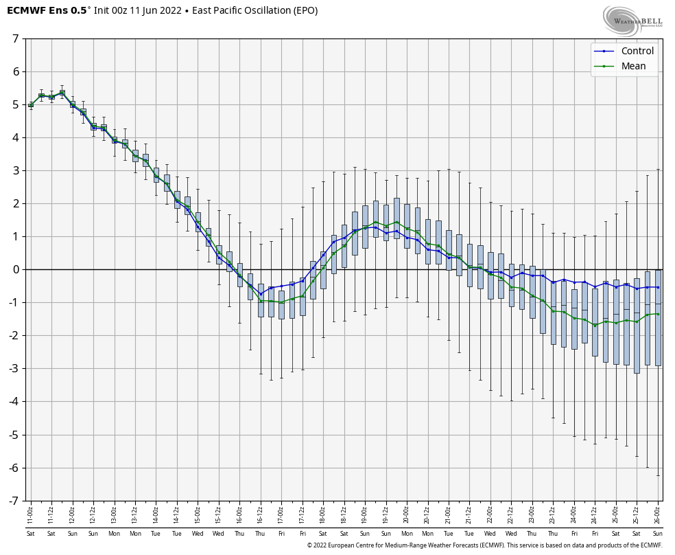

We’ll have to obviously keep an eye on the MJO, but the end result will likely continue to be a scenario where just as soon as you might think a persistent pattern is getting set to “lock-in,” we’ll see a transition out of the said pattern for a period of time.
“Transitional” is the key word we’ll continue to ride for the foreseeable future.
Permanent link to this article: https://indywx.com/2022/06/11/taking-a-stand-on-the-heat-in-the-longer-term/
Jun 10
Updated 06.10.22 @ 7:40a
You must be logged in to view this content. Click Here to become a member of IndyWX.com for full access. Already a member of IndyWx.com All-Access? Log-in here.
Permanent link to this article: https://indywx.com/2022/06/10/video-scattered-storms-heat-and-humidity-builds-early-next-week/
Jun 09
Updated 06.09.22 @ 1:45p
You must be logged in to view this content. Click Here to become a member of IndyWX.com for full access. Already a member of IndyWx.com All-Access? Log-in here.
Permanent link to this article: https://indywx.com/2022/06/09/video-serious-heat-humidity-builds-into-early-next-week-discussing-when-cooler-times-return/
Jun 08
Updated 06.08.22 @ 7:27a
You must be logged in to view this content. Click Here to become a member of IndyWX.com for full access. Already a member of IndyWx.com All-Access? Log-in here.
Permanent link to this article: https://indywx.com/2022/06/08/video-detailing-todays-severe-threat-few-days-of-intense-heat-humidity-arrives-next-week/
Jun 07
Updated 06.07.22 @ 6:35p
You must be logged in to view this content. Click Here to become a member of IndyWX.com for full access. Already a member of IndyWx.com All-Access? Log-in here.
Permanent link to this article: https://indywx.com/2022/06/07/video-severe-weather-episode-tomorrow-afternoon-1st-heat-wave-of-the-season-dialed-up-next-week/
Jun 06
Updated 06.06.22 @ 7:50a
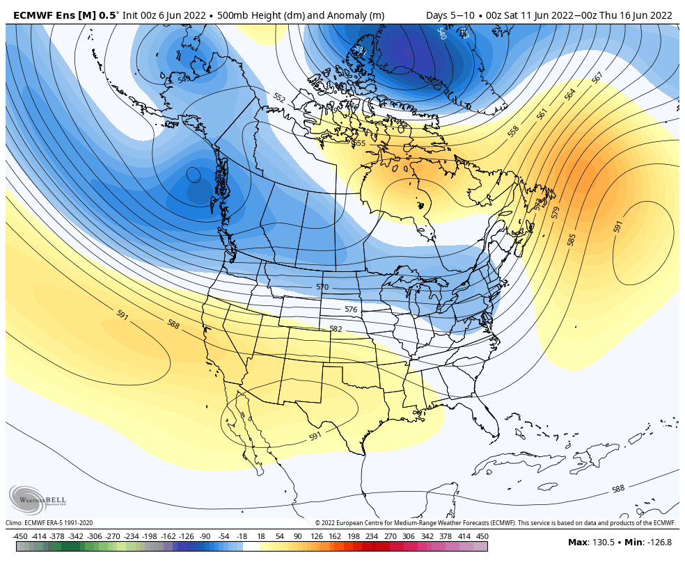
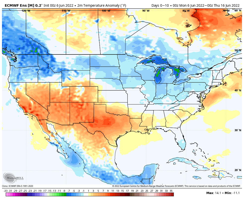
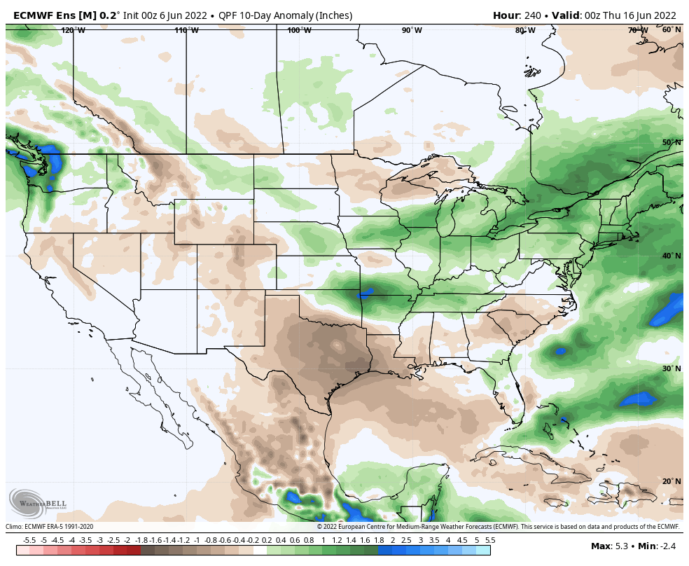
Forecast Period: 06.06.22 through 06.16.22
After a calm open to our Monday, a storm system will blow in from the west and lead to an expanding area of storms this afternoon into the evening. From the area in and around Indianapolis and points south, some of these storms could become strong to severe (large hail and damaging winds being of greatest concern). Localized flash flooding is also possible due to the training nature some cells may take. Unfortunately, a rough evening commute is a good bet due to the timing of this storm complex.
After a quiet Tuesday, a similar setup can be expected of that from today on Wednesday. We’ll time the afternoon and evening hours for the arrival of the unsettled, stormy conditions. Additional chances of strong to severe storms will be likely, including threats that are similar to today.
Finally, another system will deliver a round of showers and storms Friday. The good news is that for the 3rd consecutive weekend, it appears as if the area will enjoy pleasant weather, including unseasonably cool, refreshing temperatures.
As we flip the page to next week, the week will open with a similar pattern dominating (northwesterly flow aloft) that will have to be monitored for the likelihood of additional storm clusters. Thereafter, models are in a bit of a disagreement on what takes place with building heat to our west. It’s possible this hot dome nudges far enough east to heat us up the middle of next week. With that said, indications are that even if this is the case, we wouldn’t see prolonged hot, humid times that our friends across the southern Plains and Southwest are contending with.
10-Day Rainfall Forecast: 1.5” to 2” (localized heavier amounts in excess of 2” will be likely where storms train).
Notes and Asides: Have been on the road the past few days. Travel day tomorrow but will be back at home base by evening. As such, please expect a delay in tomorrow’s post. We’ll have a client video posted towards late afternoon.
Permanent link to this article: https://indywx.com/2022/06/06/weekly-severe-and-agwx-outlook/
Jun 05
Updated 06.05.22 @ 4p 1.) Our pleasant weekend will give way to an unsettled open to the work week as the first in a series of storm systems blows into…
You must be logged in to view this content. Click Here to become a member of IndyWX.com for full access. Already a member of IndyWx.com All-Access? Log-in here.
Permanent link to this article: https://indywx.com/2022/06/05/sunday-afternoon-rambles-4/
Jun 04
Updated 06.04.22 @ 7:08a
We sure are on a nice streak as of late with our weekend weather! If your plans don’t include outdoor activities this weekend, might I recommend a change in the schedule! Dry time will hold across central Indiana into the daytime Monday while we watch showers impact our friends to the north (a few showers will be likely Sunday for our far northern IN subscribers). Pleasant, refreshing air for this time of year will be an added bonus this weekend.
The next opportunity of rain, locally, will arrive Monday, especially during the afternoon and evening hours. Even this shouldn’t be a big deal though. At one time what will likely look like a formidable area of rain will likely diminish in rather quick fashion as it moves into the dry airmass in place across central IN.
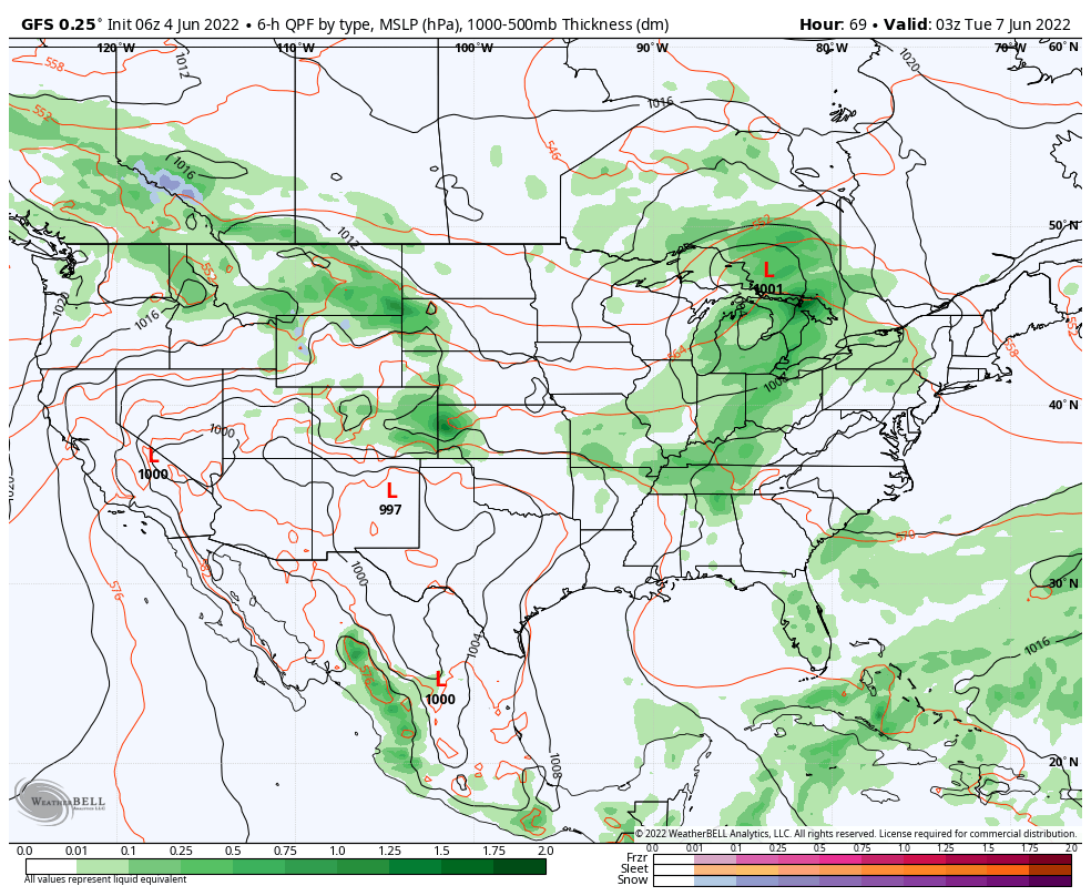
This particular front will blow through Monday night and Tuesday morning. A northwesterly flow aloft will dominate next week. Mild temperatures will continue, especially by June standards. (We’ll have several days by the middle and latter part of next week in the 70s for highs and 50s for lows). The next chance of rain will arrive with a secondary cold front Wednesday.
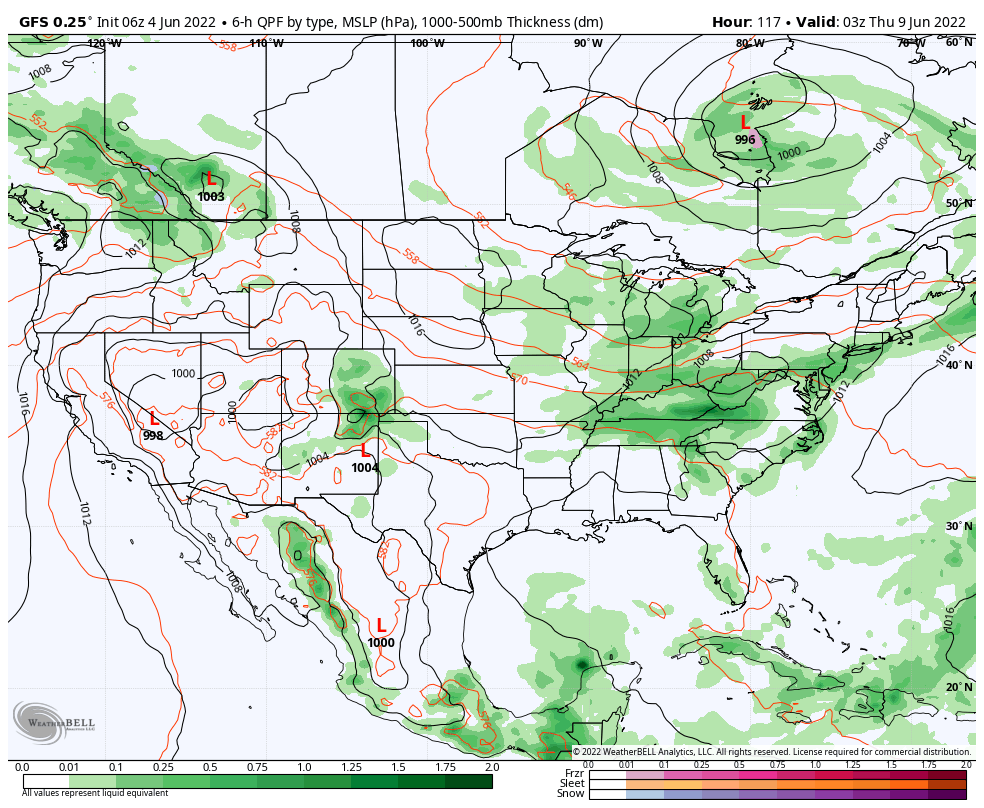
Finally, the “caboose” in the series of systems next week will blow through Friday with another round of rain. It’s this system that appears to have the best chance of tapping into a higher moisture source so the early lean is that we’ll see the most widespread rain in the series to close the work week.
All total, rainfall amounts with the first 2 systems appear paltry at best (on average less than 0.25” from both). Early indications are heavier amounts of rain will fall with Friday’s system. We’ll bracket 0.50” and 1.5” of rain in the week ahead for the majority of central IN rain gauges.
In the meantime, continue to enjoy our pleasant early summer weather! We’ll keep an eye on the upcoming week’s trends and update accordingly moving forward.
Permanent link to this article: https://indywx.com/2022/06/04/nice-timing-looking-ahead-to-next-week/